unfortunately I did not take screenshots of the new routings. Re-routing was done via Internet Connection (via Bluetooth hotspot), at least I did not saw a hint that Brouter was used. Routing options: extra curvy route, but I thought this is only effective in planning mode, not in navigation mode…?
However, I can reproduce what I did, but to support I need to know what exactly I shall log. Is a screenshot of the new calculated route enough or shall I export re-calculated route in *.kurviger format?
start navigation with ‘navigate to start point’ (recalculated1.kurviger) recalculated1.kurviger (58.2 KB)
deviate on the way to startpoint and force App to recalculate (recalculated2.kurviger) recalculated2.kurviger (37.4 KB)
continue deviating from re-calculated route to force recalculation (recalculated3.kurviger) recalculated3.kurviger (34.3 KB)
continue deviating from re-calculated route to force recalculation (recalculated4.kurviger) recalculated4.kurviger (26.8 KB)
continue deviating from re-calculated route to force recalculation (recalculated5.kurviger) recalculated5.kurviger (20.1 KB)
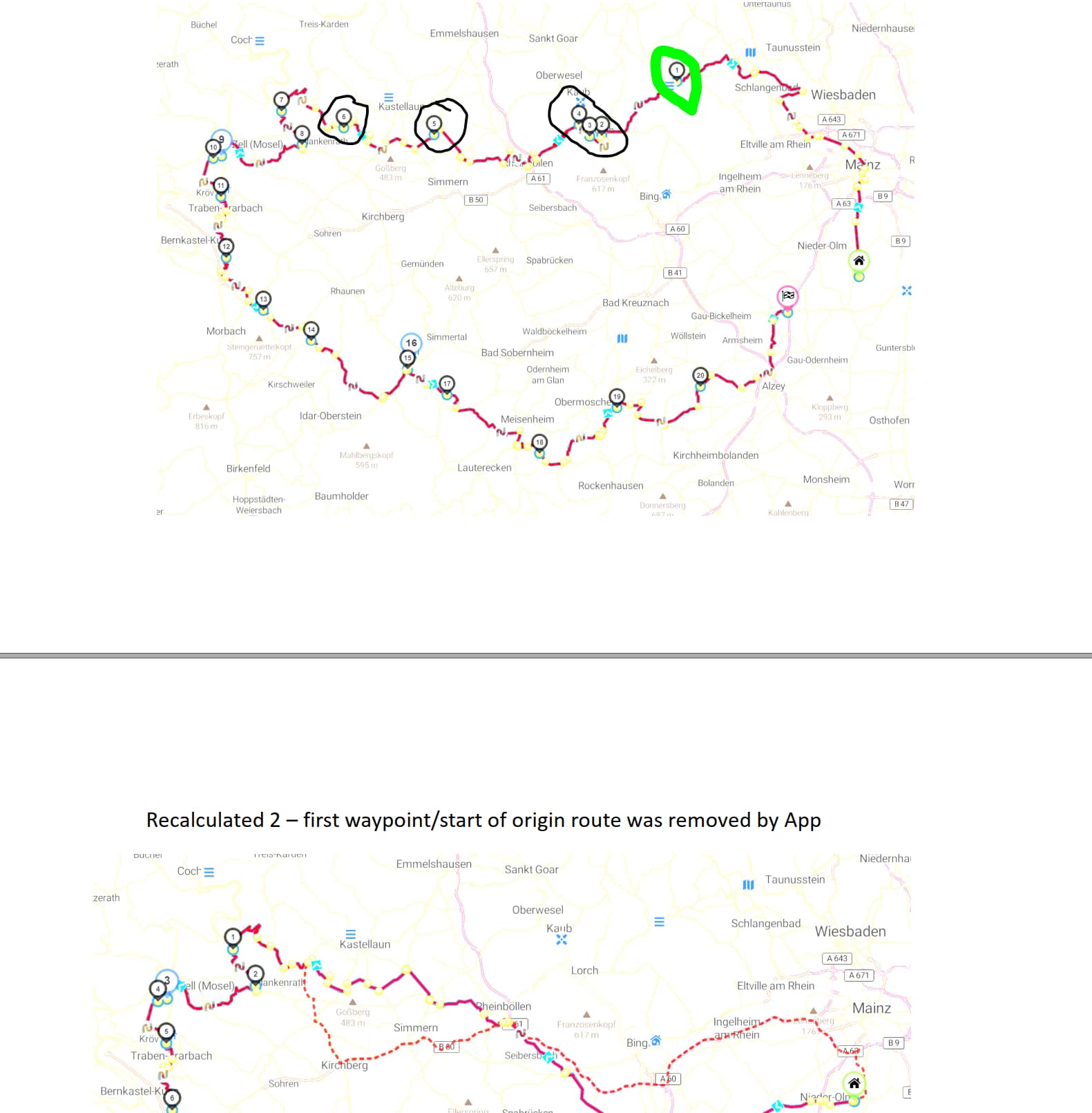
It seems that with each recalculation the upcoming shaping points are removed, I put this in the pdf file. recalculated routes.pdf (2.8 MB)
So I learned to never leave the first calculated route to a meeting point and rely on recalculation. Not really an issue, but good to know and to store always the desired route in *.kurviger format on the mobile used as navigation device. With the option ‘strict navigation’ I thought that the route to the start can be modified in case of deviation, but I did not expect shaping points or waypoints of the original route to be removed.
[edit]according to traffic conditions I could not stop exactly after each recalculation, therefore sometimes more than one shaping point was removed prior I could save the new route[/edit]
It looks like an unexpected behavior, however I must first analyze your examples
and try to reproduce it, so I can see internally what happens, before saying more.
Did you notice if 1 or more than 1 waypoints were removed?
I see the from 1st recalculated to 2nd recalculated file the start point and the following 5 shaping points were removed, you can see this in the attached pdf:
But I cannot say definitely how often the recalculation was started between deviating the first time from the route until first safe - this would have been too dangerous to stop abprubtly in running traffic
So the Pro App did a correct job, all deviations were redirected to the origin starting point. It also did not start the recalculation as often as the beta 2.2.18. recalculated pro.pdf (2.7 MB)
Difference aside the App: the mobile with the Pro App holds a SIM for internet connection and is not connected via Bluetooth. But the recalculation on the mobile less SIM in planning mode works fine via Bluetooth, so I assume the internet connection is stable (crossing my fingers).
But even if the recalculation would be done via Brouter, should it not also lead to the starting point of the origin route if you have yet not reached it, resp. navigate to the next possible waypoint if your are already on the route?
Yes, I did not skip any waypoint. I stopped when the new distance was displayed in the upper right corner and saved the new calculated route, nothing else
Will do and send it over, but have to wait for better wheather…
Never used something like this - any recommendation which one I should use?