A post was merged into an existing topic: Website: Waypoint names
Fantastic! This is a great feature! This is the only item I really missed so far. It should be available on the desktop version before the app since most planning is done on large screens.
Development is done by different people and the 2 platforms are independent of each other.
Here we can discuss app’s implementation. The website has its own separate feature topic:
Hallo,
auch ich fände es Prima, wenn ich die Wegpunknamen in Web-Planer eingeben kann. Genau das wollte ich gerade mit einigen Wegpunkten im Web-Planer machen.
Werden diese Namen dann auch in der GPX-Datei gespeichert?
Viele Grüße
Basti
You can use the new GPX (offline) format which supports waypoint names (until the server is updated).
Die Benennung der “wichtigen” Wegpunkte in kurviger-pro klappt prima! Sie werden sogar nach dem Export (.kurviger “offline” ) beim Re-Import von kurviger.de übernommen und bleiben in den meisten Fällen auch nach weiterer Bearbeitung der Route erhalten. Siehe Kurviger
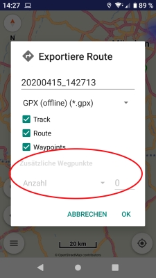
Beim Export mit (.gpx “offline”) - den ich nur zur Weitergabe an Mitfahrer benötige - fehlt mir noch etwas. Ich würde gerne auch hier zusätzliche Wegpunkte zur Vereinheitlichung der Strecke einfügen - geht das? DANKE!
Naming the “important” waypoints in kurviger-pro works great! They are even taken over after the export (.kurviger “offline”) when re-importing into kurviger.de and in most cases remain even after further processing of the route. see Kurviger
When exporting with (.gpx “offline”) - which I only need to pass on to fellow riders - I still miss something. I would like to add additional waypoints to unify the route - is that possible? THANK YOU!
Sorry - the link above doesn’t work correctly - just import the attached kurviger-file to see the names of some waypoints. Sharing the route seems to rename all waypoints …
20200415_143431.kurviger (23.9 KB)
That is not possible in GPX (offline) format, it exports the route unmodified.
The website will support waypoint names later:
Hello, thanks for adding the feature Waypoint-Names. It would also be nice to have the Waypoint-Names imported from .gpx files. Currently the waypoint names are exported to gpx but not imported.
If wpt elements in GPX file have filled their “name” tag then their names are imported too.
Or do you have some sample GPX that does not work?
1 Like
I simply exported a Route with the Kurviger App as gpx and imported the Route again. Waypoints-Names exist in the exported GPX-File, but when reimporting the Route specific Names are lost. Using 1.13.3 Beta
(please post also the export & import dialog details, so we can understand & reproduce)
When export waypoint names, must use Kurviger or GPX (offline) formats.
Probably you select “Route” instead of “Waypoints” when export & import a route?
I can add parsing of names also from the route rtept elements inside the GPX file.
Yes i did this as you said. Parsing names from the route rtept<> tags would be nice. Think about importing gpx routes from a different source with existing names. Nice work you did on the current Beta.
It will be available in next version.
2 Likes
Hi,
I just played a little bit with the Waypoint Names, I like it, thanks for the implementation.
And I appreciate especially one feature: I use the search function e.g. searching a mountain pass.
After long tap on the search marker and selecting “Add as waypoint” , the name of the mountain pass is copied to waypoint automatically - good job!
Thanks and regards
Markus
1 Like
Hi,
following a hint from devemux in an other tread I did some tries with the waypoint list and waypoint names:
If I change a via point with a given (and displayed) name to shaping point, the name is not displayed any more but just the text “shaping point”.
Also the “edit name” button is disabled.
Nevertheless the prevously given name is stored (I appreciate that!): If I export a .kurviger file, I can still see the name of the shaping point in it, if I switch back that point to via point, the given name is displayed again - that’s good!
I’d like to use the name information also for shaping points to identify them (e.g. in waypoint list or during planning on the map), because a “talking name” can be given to identify that shaping point, thats easier to handle than keeping numbers in mind.
Therefore I propose:
- display in waypoint list also the given name of shaing points, if available (you can see that it is a shaping point by the icon)
- enable also “edit name” button for shaping points
- display shaping point name also in the bubble on the map after long press on the marker (you can see that it is a shaping point by the marker icon)
- perhaps it would be useful to have different functions dependant on where I tap on a waypoint in the list, example: Tapping on the icon on the left toggles via <-> shaping, tapping on the name opens edit field to change name, tapping on a 3rd column opens context menu, tapping on a 4th column selects waypoint to shift it up/down via arrow buttons below list. Thats just an idea, I can not judge the effort to implement such an interface
Remark: In other functions as navigation etc. the shaping point name should be handled as before ( = no hint, name ignored ?).
Regards
Markus
1 Like
More important is what is common, i.e. the rule for shaping points.
(not how we like them to be)
So how all other routing services handle shaping point names?
Any other have them? Because we should remain compatible.
1 Like
Hi,
I agree, of course.
BaseCamp is just a planning tool (for PC or MAC) - so there will be no alerts anywhere, of course, this is dependant on the used Garmin device used to drive the route afterwards.
But I can confirm the rules you mentioned for ShapingPoints for Garmin devices I know: No alert, no arrival time. But the name of ShapingPoints can be displayed / changed (in BasceCamp and on Navi).
This is consistent to the behaviour of my BMW Navigator 5 (Garmin), and probably will be the same for BMW Navigator 6, Garmin Zumo 590/595 and other Garmin Devices which can distinguish between ViaPoints and ShapingPoints.
There are two further important differences between ViaPoints and ShapingPoints @ Garmin devices:
- Starting a route you can choose a ViaPoint where to enter the route (ShapngPoints not shown in selection list)
- ViaPoints have to be passed during Navigation, in case of a detour the device tries to lead you back to the ViaPoint you did not reach - in that case you have to skip that ViaPoint manually
- the “skip waypoint” function just skips the next ViaPoint on the route, including all ShapingPoints before thatViapoint.
For BMW N5: result of skip: next point in route will be 1st point after skipped ViaPoint (can be a ShapingPoint or a ViaPoint).
Regards
Markus
Thanks for the details, those are about Garmin universe.
We should examine also how shaping points are handled in Google Maps, HERE WeGo, etc.
(and used in their popular navigators)
Do they use / need shaping point names?