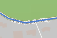
The z-layer of the mapping display appears to draw the route line over the top of the map. This means that the line is drawn over the top of street names, making the name illegible.
If I zoom in on the map to read the street name, the purple line showing the route expands in width and size also. The line still covers the street name and I can’t read it.
Some themes have more legible font than others. This helps, but doesn’t solve the problem.
This makes it difficult/impossible to type the street into my GPS when I’m on the move and using Kurviger’s superior route planning. (I can’t transfer files directly to my GPS so I have to type the route into the GPS.)
It’s currently not possible to hide the route line in the mobile view. On the desktop you can use the R button to hide the route. We are planning on improving this in the future
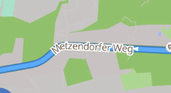
Da habe ich mich schon mal drüber geärgert. Aber das ist nur im Planungsmodus so:
nicht während der Navigation:
Interessant wäre in diesem Zusammenhang, wenn sich die Routenspur (bei der App) über einen Button aus-/einblenden ließe,
oder nur kurz ausblenden, solange man gedrückt hält.
In diesem Fall könnte man auch schnell mal sehen, auf was für einen Straßentyp die Route verläuft. Das ist auch gelegentlich hilfreich.