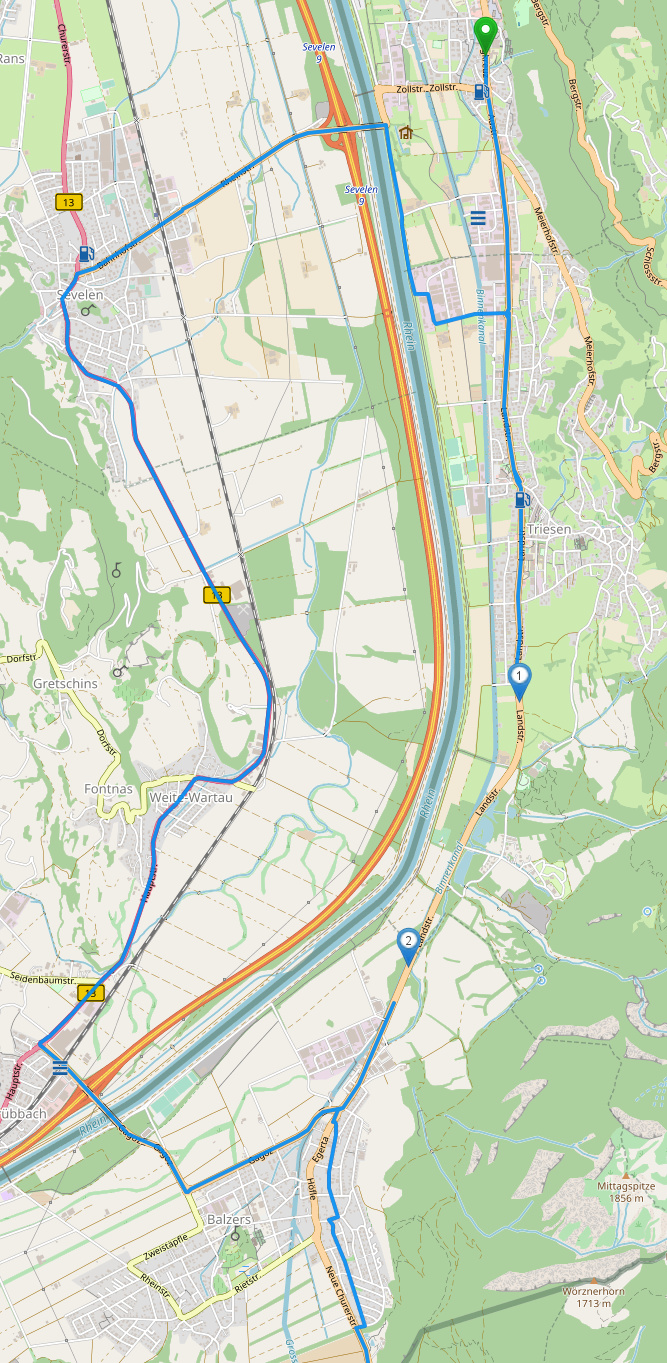
when planning a route that includes streets in Liechtenstein I hit upon the section shown in the picture (Vaduz.png). I do no know the region yet, but cannot imagine that the main road between Vaduz and Balzers is not viable for normal traffic:
And there is (obviously) another routing error in the same image: Just south of route point 2 the main road is left, and a smaller road, even with a double turn, is taken in “fastest routing”. Once again, I do not think this is realistic. I guess there are some errors in the database behind.
thanks for the report. It would be great if you could include a link to a short route that shows the error when reporting a routing error.
The routing error through the residential area is most probably due to an incorrect maxspeed tagging resulting in the route to be faster using the residential street.
The reason that the main road is not used is most probably due to this weird tagging. Also name=Landstraße doesn’t seem very accurate.
Both changes were made by the same user and the user still seems to be active on OSM. So I think the best approach is to contact the user and ask about this. Would you mind writing the user a message and ask about these roads?
Robin I think it’s admirable that you try to improve/increase the OSM community but I’m afraid that without detailed tutorials you lose most of us here, how on earth do you check that a user is still active in OSM?
Every user has an edit history. The user in question last edited something on OSM 25 days ago, he joined OSM in 2009 and made over 500 edits. It appears he was more active in the past than he is now, but I would assume he is still active enough for a conversation .
Thanks! If there is no answer for a longer period of time, please feel free to let us know than we can still think about what we should do in this case.
Just a small follow-up: We drove the said route yesterday, and it was as anticipated: The main road is absolutely viable. So definitely a categorization error.
No special signs observed, at least not relevant for passenger car usage - just a simple main road passing a town. We didn’t watch out for special purpose vehicle limitations, though.
I don’t mind improving the data, but I don’t know if I am the right one to do it given the fact that I drove the road just once?
Yes you are . You mad a recent local observation and found the data on OSM to not match your observation. So you are exactly the right person to change the data. Everyone can help to improve OSM, there is no special training required, just reading a tutorial and at first I would recommend to only change data if you are sure that you are actually entering the correct thing. For access tags like in this situation, the right thing would be to remove most of them, if there are no special signs, the default is assumed. For a highway=secondary the default is that everyone (let’s not talk about special cases like horse etc.) can use it. Pedestrians are discouraged unless there is a sidewalk, which can be tagged as well.
This is so cool, I have the same thought each and every time as well
“Am I really supposed to do this? Won’t the others tell me I’m an idiot and don’t know things from being there only once”
I think the point with OSM is really to learn to be less worried and more courageous Great that you decided to do it
One more comment about this. Many OSM contributors are not very concerned about routing. Many people map to have a beautiful map and don’t care that much about “invisible” properties. This and also that the routing does not update immediately like the map rendering are IMHO one of the reasons why many routing issues don’t get resolved for longer spans of times, because you cannot find them by just looking at the map or run simple algorithms like keepright.
Ok so to end this once and for all, I drove this route two weeks ago in my motorcycle holiday, on the way to Tuscany. And there are no restrcictions whatsoever, so I edited OSM and I’m looking forward to Kurviger driving there soon
I encountered some construction sites in a very nearby town and they diverted the traffic off to one residential road for one side of the traffic and another residential road for the other side. So that seems to be a normal practice and somebody living there could probably update the OSM sooner or later