Tour: 28042018BanyulesCoustouges
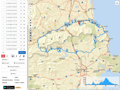
162km – 5h
!! Preferred for Enduros, heavy dirt track included 5km at WP 7->8 !!
Diese Mal starte ich in Laroque des Alberes , wo ich frueher gewohnt hatte.
Wir wollen eine kleine Sonntagstour machen und irgendwo lecker zu Mittag essen. Ich hatte als Tip das Restaurant EL MOLI D’EN ROBERT in Maçanet de Cabrenys bekommen (WayPoint 11), ansonsten standen noch das Restaurant EL CORRAL DE SANT QUIRZE (WP8) und das Restaurant CAN MACH in TAPIS (WP12) zur Auswahl.
Zuerst aber ein bisschen fahren, entlang den Alberes in Richtung Kueste und ab Argeles-sur-Mer die Schnellstrasse nach Banyules-sur-Mer , vorbei an Collioure und Port Vendres . Ab hier verschmaelert sich die Strasse und fuehrt in Serpentinen hinunter in die Bucht von Paulis und dann ueber einen Hoehensattel hinab nach Banyules-sur-Mer – die ersten 25km und 30 Minuten.
In Banyules gehts rechts ab und wir folgen dem Fluesschen La Baillaury in Richtung seiner Quelle in die Berge. Die Strasse ist nur 1,5 spurig, schlaengelt sich dem Fluss entlang durch das Tal, hat aber einen guten Asphalt ohne Flicken. Nach 10km sind wir auf dem Col de Banyles angekommen, 361m Hoehe und haben seit der Abfahrt fast eine Stunde fuer die 36km gebraucht.
This time I start in Laroque des Alberes, where I used to live.
We want to do a small Sunday tour and have a delicious lunch somewhere. As a tip I got the restaurant EL MOLI D’EN ROBERT in Maçanet de Cabrenys (WayPoint11), otherwise I had the restaurant EL CORRAL DE SANT QUIRZE (WP8) and the restaurant CAN MACH in TAPIS (WP12) to choose from.
But first we drive along the Alberes towards the coast and from Argeles-sur-Mer the highway to Banyules-sur-Mer, passing Collioure and Port Vendres. From here the road narrows and leads in serpentines down to the bay of Paulis and then over a saddle down to Banyules-sur-Mer - the first 25km and 30 minutes.
In Banyules we turn right and follow the river La Baillaury towards its source in the mountains. The road is only 1.5 lanes, winding along the river through the valley, but has good asphalt without patches. After 10km we arrive at the Col de Banyles, 361m high and it took us almost an hour for the 36km since our departure.
Jetzt geht es in Serpentinen bergab in Richtung Espolla, bis wir den Abzweig bei Mas Plis erreichen.
Von hier aud fuehrt eine Piste ueber einen Hoehenzug hinunter zum Kloster St Quirze und dem dazugehoerigen Restaurant (WP8).
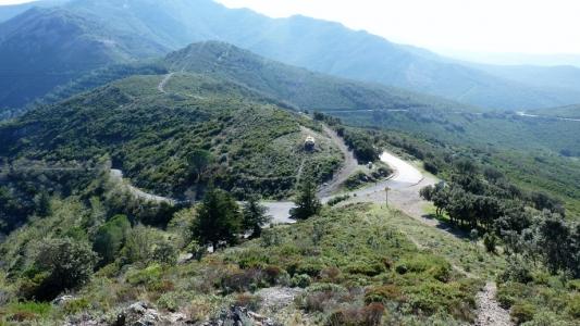
Now we drive downhill in serpentines towards Espolla until we reach the junction at Mas Plis.
From here, a dirt track leads over an elevated train downhill to the monastery St Quirze and the corresponding restaurant (WP8).
Nach einem Grande Creme (ordinaer: Milchkaffee) und einem kleinen Rose gehts dann ueber eine kleine gut asphaltierte Strasse das Tal hinunter und wieder hinauf nach Rabos . Von dort aus fahren wir rechts weiter auf der GI-602 ueber Capmany weiter in Richtung N-11 und dann Darnius .
Kurz hinter Darnius beginnt die „Rennstrecke“ nach Coustouges und der franzoesischen Grenze.
35Km breite ausgebaute Strasse, die sich in mehr bzw weniger weitlaeufigen Kurven durch die Pyreneen hinauf in Richtung Coustouges schlaengelt und als Teststrecke den heimischen Moped Fahrern dient. Dementsprechend sind an bestimmten Tempo-Limit Stellen auch am Wochenende die Radarfotografen zu finden.
In Maçanet de Cabrenys muessen wir links in eine schmale Strasse abbiegen, die nach 1,5km zu einer Piste wird, die aber ohne Schlagloecher und ziemlich flach ist. Es geht in eine weite Schlucht hinunter, einem kleinen Fluss entlang und dann sind wir da, bei Roberts Muehle (WP11).
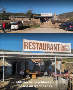
Es ist ¼ vor 1 und man fragt uns nach unserer Reservation – S…… !! Aber man bietet uns einen Tisch an, den wir aber bis um ½ 3 geraeumt haben muessen – 1,5h sollte uns eigentlich fuers Essen reichen! Ja, die Spaniere essen spaet zu Mittag, dafuer aber lange!!
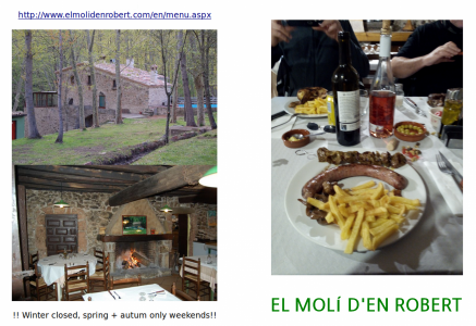
Der Tip hat sich gelohnt, die Botifara ist fast reines Fleisch und der Lammspiess zergeht auf der Zunge – butterzart!! Alles mit einem Roten bzw Rose gespuelt sind wir mehr als gesattigt!!
After a Grande Creme (ordinaer: Coffee with milk) and a small rose we drive down a small asphalted road through the valley to Rabos. From there we turn right onto the GI-602 via Capmany towards the N-11 and then onwards to Darnius.
Shortly after Darnius the “race track” to Coustouges and the French border begins.
35 km wide road, which winds its way up through the Pyrenees in more or less wide curves towards Coustouges and serves as a test track for the local bike riders. Accordingly, the radar photographers can also be found at certain speed-limit locations on weekends.
In Maçanet de Cabrenys we have to turn left into a narrow road, which after 1,5km turns into a dirt track, but without potholes and quite flat. It goes down into a wide gorge, along a small river and then we are there, at Roberts mill (WP11).
It is ¼ to 1 and they ask us for our reservation - S… !! But then they offer us a table, which we must have cleared until ½ 3 – 1 ¾h should be enough for us to eat! Yes, the Spaniards eat late at noon, but for a long time!
The tip was worth it, the Botifara is almost pure meat and the lamb skewer melts on the tongue - tender as butter! Everything washed with a red or rose we are more than sated!
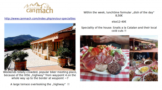
Wir beschliessen den Kaffee bei CAN MACH einzunehmen.
Eine knappe ½ Stunde Fahrt und wir sind da – und ergattern grade noch einen kleinen Tisch auf der Terasse. Die Parkplaetze rundherum sind ueberfuellt mit Sonntags Touristen zur einen und zur anderen Haelfte mit Motorradfahrern aus Frankreich und Spanien.
We decide to take the coffee at CAN MACH.
A short ½ hour drive and we’re there - and just getting hold of a small table on the terrace. The parking lots all around are overcrowded with tourists on Sundays to one side and half with motorcyclists from France and Spain to the other side.
Nach einem Kaffee und etwas Verdauung in der Sonne gehts dann der restlichen Etappe entgegen. Ab der Grenze in Coustouges 830m Hoehe, geht es bergab ins Tech Tal; von dort aus schlaengelt sich die Strasse immer dem Tech Fluss entlang hinunter bis nach Le Boulou . Ab hier nehmen wir dann die Schnellstrasse zurueck nach Laroque .
Das Fazit: nicht nur die Strassen, sondern auch das Essen und das Wetter haben uns heute verwoehnt, mit 23 Grad und Sonnenschein!!
After a cup of coffee and some digestion in the sun, we head for the rest of the stage. From the border at Coustouges 830m altitude, we descend into the Tech Valley; from there the road winds along the Tech River downhill to Le Boulou. From here we take the expressroad back to Laroque.
The result: not only the roads, but also the food and the weather have spoiled us today, with 23 degrees and sunshine!
28042018BanyulesCoustouges.kurviger (26.0 KB)
