Anzeige nächstes Ereignis als kleiner Kartenausschnitt statt Symbole, kann auch gerne nur als Hinweis zum Ereignis bei 1.000 m zuvor eingeblendet werden. Bilder sagen wirklich viel.
Weiß nicht wie schwierig das ist, könnte mir aber vorstellen, dass die Generierung von Symbolen nicht gerade leicht ist bei der Vielfalt von Fällen.
Display next event as a small map section instead of icons, can also be displayed only as a hint to the event at 1,000 m before. Pictures really say a lot.
Don’t know how difficult this is, but I could imagine that the generation of symbols is not easy with the variety of cases.
Interesting idea - as you said, for now low prio, but I can see some potential here. There are probably cases were this creates issues or doesn’t work.
@Thoka What advantage do you see in map sections compared to symbols?
Personally, I would prefer symbols because they are faster and easier to understand.
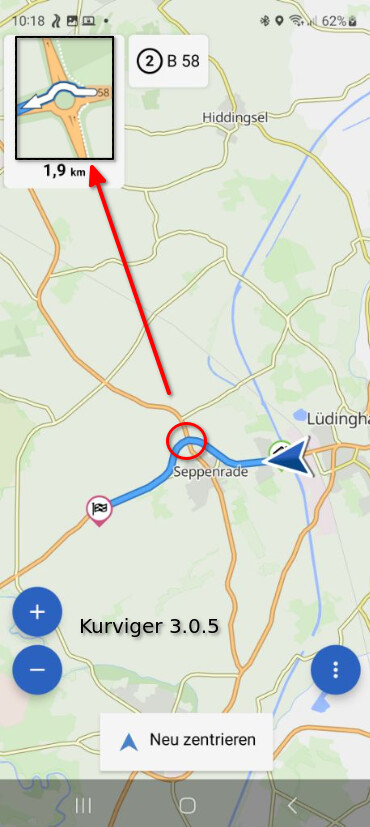
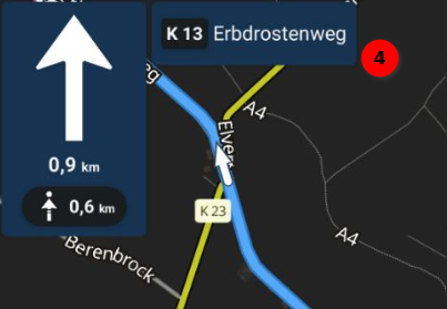
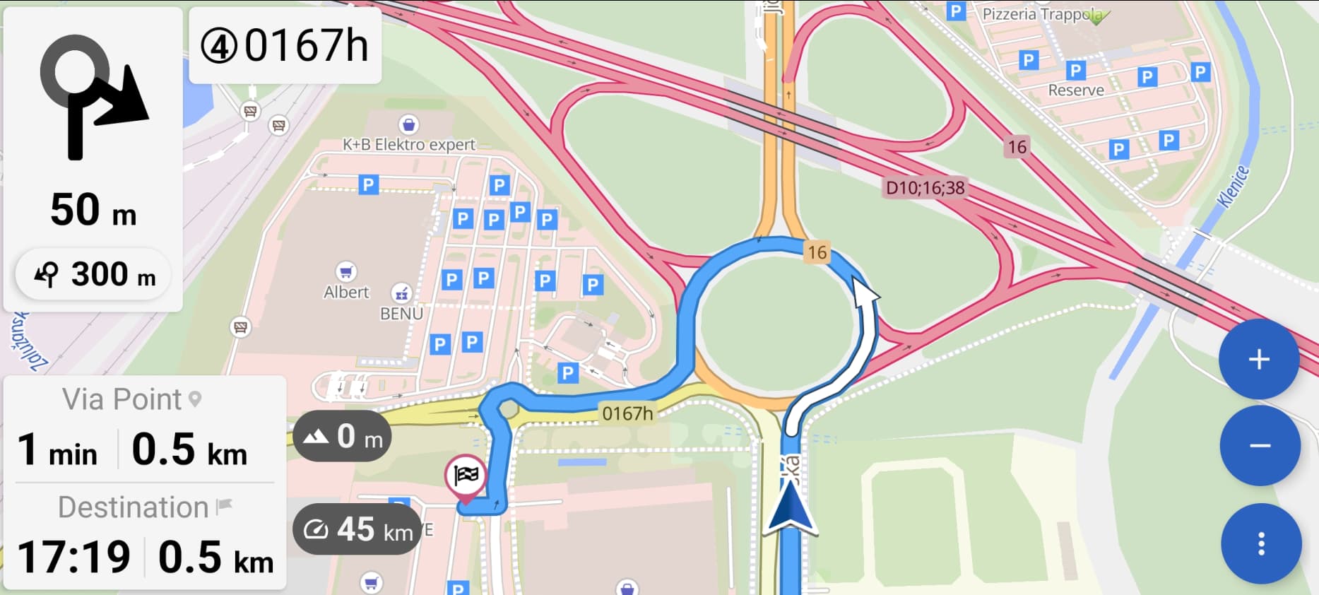
Here are some examples from the simulation. In the enlarged map sections I can see more of the environment than the symbols could give me. Well to recognize in the highway intersection (1), but also in the traffic circle (2) and the left-right combination (3). The latter situation is also often scarce in the announcements, has happened to me often to have missed the second point. Example (4) is the one with 4 announcements “keep left”.
Another advantage would be that quite complicated routings are very quickly clear in the picture, but this is not easy to represent via symbols.
And an advantage could also be that the main map can remain in the original zoom level for an overall view, but you can still see in detail what is coming, and that very early and not only when you reach the position.
I agree, the symbols are very good in their perception.
All in all, it’s just an idea, maybe as an optional representation to the symbols.
Maybe it is at the end of the day also nix, who knows.
Hier einige Beispiele aus der Simulation. In den vergrößerten Kartenausschnitten kann ich mehr aus dem Umfeld erkennen als das es mir die Symbole geben könnten. Gut zu erkennen im Autobahnkreuz (1), aber auch im Kreisverkehr (2) und der Links-Rechtskombination (3). Letztere Situation ist auch in den Ansagen häufig knapp, ist mir schon häufig passiert den zweiten Punkt verpasst zu haben. Beispiel (4) ist jene mit 4 Ansagen “links halten”.
Ein weiterer Vorteil wäre, dass durchaus kompliziert Wegeführungen im Bild sehr schnell klar sind, was über Symbole aber nicht einfach darzustellen ist.
Und ein Vorteil könnte auch sein, dass die Hauptkarte in der Ursprungszoomstufe verbleiben kann für eine Gesamtübersicht, man aber dennoch im Detail erkennt was kommt, und das schon sehr frühzeitig und nicht erst bei Erreichen der Position.
Ich gebe Dir recht, die Symbole sind sehr gut in ihrer Wahrnehmung.
Ist insgesamt ja auch nur eine Idee, evtl. als optionale Darstellung zu den Symbolen.
Vielleicht ist es am Ende das Tages ja auch nix, wer weiß.
Personally I prefer the information of the number of the exit in the roundabout, as it was in Kurviger 2.
The idea of the @Thoka partner seems excellent to me.
Ein weiterer Vorteil, vermutlich aber nur für wenige Leute, ist die Ausrichtung. Fahre immer mit Ausrichtung der Karte nach Nord, liegt vermutlich daran, dass ich im Zeitalter der Papierkarten mit dem Reisen gestartet bin. Symbole sind immer in Fahrtrichtung, für einen Sub-Kartenausschnitt könnte man hier potenziell entscheiden. Bin damit aber vermutlich eine kleine Minderheit, noch viel kleiner als die der Linkshänder.
Another advantage, but probably only for a few people, is the alignment. Always drive with orientation of the map to the north, is probably because I started traveling in the age of paper maps. Symbols are always in the direction of travel, for a sub map section could potentially decide here. Am with it but probably a small minority, still much smaller than the left-handed.
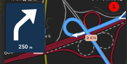
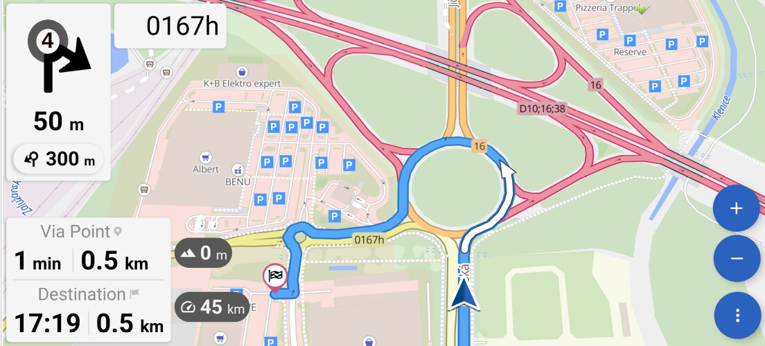
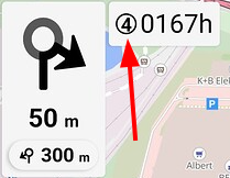
and maybe the roundabout symbol just without the exit arrow, if the mismatch is not due to some OSM information problem, or the problem in OSM is frequent…
maybe a solution for you? When you reach the traffic circle, the zoom starts (if switched on). If the position still fits this would be perfekt for me. The number (1) for the exit is curious, would a render help? I don’t know.
just to transform the “real view” - you are speaking about,
into the “symbol” - I am a fan of…
The “symbol” orientation might then be according the “riding direction” or “north up” depending on navigation setup…
But I am quite sure, this is possibly not so easy to introduce into the app…
… so I think, it should be investigated, where the mismatch comes from (erroneous data in OSM, how frequent, or other reasons…)
… imagine, having this in the tank bag, under the foil, with external cable GPS unit, with cable power delivery and cable intercom for me and my (now) wife, just regretting not having a photo of that “power-plant”…
yes, the exit no. 1 is quite weird, for me it is saying no. 4, which is correct…
…despite the wrong symbol…
I don’t think that these are issues in the OSM data, but there is an issue with the way how we calculate this angle. There seems to be an issue in GraphHopper with the angle calculation. We will be looking into this in greater detail.
So far I haven’t seen that many wrong roundabouts and it usually seems to be roundabouts with separate entry and exit lanes that are bend (like in your example) or in the example @cero has posted in the 3.0.5 feedback thread.
Und genau das ist der Vorteil der Symbole. Ich bieg nämlich in Fahrtrichtung ab.
Warum eigentlich dern Kartenausschnitt da nach oben bringen.
Automatischen zoom bei solchen Punkten auf ganz nah und oben das Symbol.
Dann hat man alles.
Die Symbole sind mittlerweile in allen Navis standard und deshalb in Zehntelsekunden wahrgenommen.
Bei dem Kartenausschnitt muss ich ja wieder genau schauen wo kom ich her wo muss ich hin.
Ich kann nur erinnern: Wir fahren mit dem Motorrad. Deshalb möglichst wenig Ablenkung sondern viel Funktion.
Das bedeutet alle swas unterbewusst funktioniert ist super. Nachdenken machts nur langsam und ungenau bzw. fehleranfällig.
Sehr gut erklärt im Buch “Die obere Hälfte des Motorrads”.
Ich biege auch in Fahrtrichtung ab. Und so war das auch hier nicht gemeint.
Ein Symbol läßt sich eigentlich nur in Fahrtrichtung darstellen, eine Nordausrichtung wäre wohl mehr als verwirrend. Ein Sub-Kartenausschnitt, den ich schon lange vor Erreichen des Punktes darstellen kann, kann ich sowohl in Fahrtrichtung als auch in Nordrichtung darstellen, das wäre machbar.
Mir geht es auch nicht darum die Symbole “wegzunehmen”, aber Symbole haben auch ihre Schwachpunkte, das Thema taucht hier ja immer wieder auf. Für mich ist die Dauer für die Wahrnehmung eine Symbols zu Kartenausschnitt äquivalent.
Vielleicht kommt das ja mal als “Option”, dann kann man sich das ja aussuchen. Die Wegeführung des nächsten Abbiegepunktes ist ja bereits “eingezeichnet”, könnte sogar einfacher sein als Ausfahrten zu zählen. Und technisch den Subkartenauschnitt in einer Richtung darzustellen könnte vielleicht einfacher sein als Symbole aus Kartendaten “konstruieren” zu müssen.
Für bessere Wahrnehmung ließe sich ggf. der Subkarten-Ausschnitt noch re-rendern für den Kontrast.
Alles nur eine Idee.
Die ersten Navi’s hatte gar nur Symbole und nicht einmal ein Karte.