I have two routes that I created 17 November this year. I have attached the .kurviger file of both routes. They are routes from home to a destination and from the destination home. Both routes use a ferry. Today I tried to make small changes to these routes and each time I did the ferry was removed from the route. There was nothing I could do to the avoidances (ferry, toll road) to get Kurviger to return the ferry to the route. There was nothing I could do with the placement of different shaping points to get Kurviger to put the ferry back in the route. This happened using Chrome on the website AND on the app 3.2.4
I live where there are several ferries so I tried the same thing on routes I had created using different ferries. They were not similarly affected. I checked online to see if that particular ferry (Mukilteo-Clinton) was out of operation. It was fine. My son-in-law works for the ferry system and I would have heard from him if a route was down or a boat was inoperable.
If you load the routes below they should include the ferry. Any change I made in either route removed the ferry.
EDIT (2 hours later): I have found that if I locate shaping points VERY close to the ferry terminals but NOT ON the ferry terminals that the route is robust everywhere else. This should not be necessary. Kurviger should recognize that the ferry is the most direct route.
Hi Gregory, I suspect that the reason is this road which is marked as service:driveway in OpenStreetMap (which is the map material that Kurviger uses).
A driveway is usually private property, so Kurviger does route through it if you force, but it really doesn’t like to do it.
Personally I’m not 100% sure how to tag a ferry access properly, maybe another OSM-Expert can jump into the thread here
I have always been able to create a route with a ferry in it. Kurviger has, up until now, treated it just like a road, as it should. I could put a shaping point right on the dock or a kilometer away from it and Kurviger didn’t care. It’s just this particular ferry route that is giving me problems. In this case, the ferry is WA SR-525, a Washington State highway. You can see on the map that it is WA SR-525 on both sides as well.
As requested, here are links to the two routes I referenced. When I produced the links, the ferry had not been excluded from the routes. On the HomeToCoupeville route you can see that just barely moving shaping point 10 closer to the ferry dock puts the ferry back on the route. On the CoupevilleToHome route, moving shaping point 6 closer to the dock brings the ferry back into the route.
You should put short route to demonstrate the problem, that makes it easier to understand. I think, you want to use this ferry, you can reach that by adding an shapingpoint to the terminal:
Someone changed the the terminal 18 days ago: highway=service, service=driveway:
For me it is not clear, if the tagging is wrong, if we have to add an access tag or if it is a bug in Kurviger.
Yes I think the service driveway tagging linked by @Patrick above is potentially wrong. If the ferry is part of the road network and supposed to be used instead of main road, I guess one could argue the previous tagging described the situation better.
If you compare OSM with Google Maps, they also lead the main road up onto the ferry. It seems this was recently changed by a mapper in OSM. I commented on the changeset in OSM, since I don’t know the local situation, it’s always hard to judge.
Thanks for looking into this weird problem. That’s above my paygrade. Maybe it will be corrected by someone who knows what they’re doing. That excludes me. I don’t know how to interpret or edit OSM.
Quite the opposite probably, all we need to fix this is your retelling as a person with local knowledge as soon as you tell us that the right-hand lane I linked above is actually used to get people onto the ferry, we can edit OSM and it will be fixed. That is the beauty of the community work in OSM
Thanks for that. I was just there Monday. The red line drawn in the link that you provided is not part of the ferry loading path. Maybe that red line is just to bracket or outline a short section of what is the ferry loading path. What actually happens is that you follow the orange section marked WA 525 and come up to the white section marked WA 525 First Street at which you immediately encounter a traffic signal. You turn left at that traffic signal and proceed into the multi-lane ferry loading area. Here is the Google maps photo of the area. The photo clearly shows everything that is the highway, WA 525. You can see from the photo that even the cars waiting in line for the ferry are on WA 525.
The great thing about the Washington State Ferry System is that motorcycles don’t wait in line for ANYTHING. They may cut in front of the ticket buying line to buy a ticket and then go to the front of the ferry loading area. Motorcycles load the ferry first and get off the ferry first.
Yup I saw the Google Streetview image, but had no idea if it was still up-to-date. But with your retelling I think I fixed it. We’ll see in 1-2 days when the servers have reloaded, whether Kurviger now routes through there
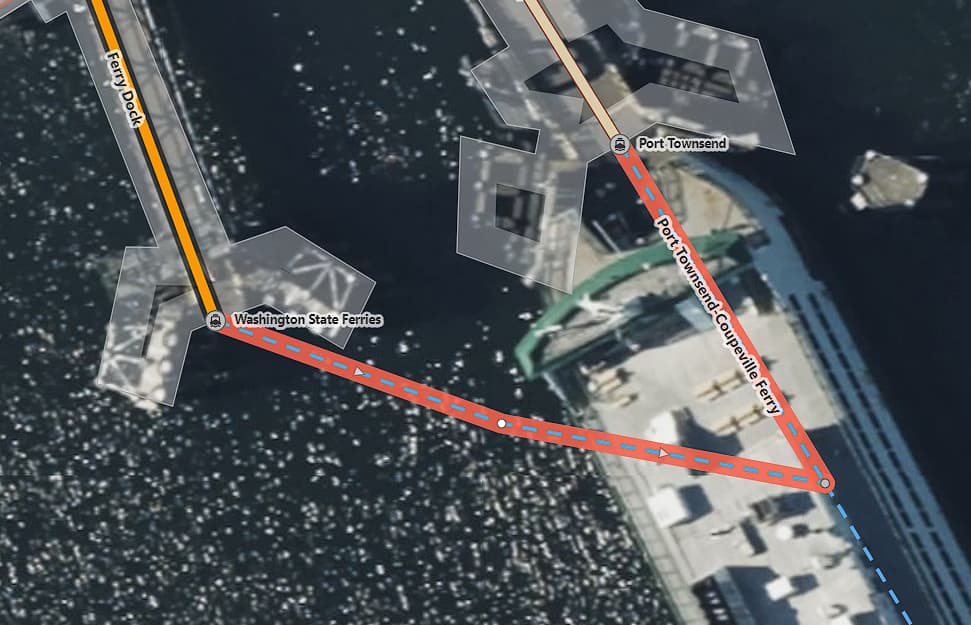
Now I see that it’s entirely impossible to include the ferry from Coupeville to Port Townsend in a route. This is a ferry that is a continuation of the highway WA SR-20. Here is the link to that route
I suspect that the reason is that these two small arms of the ferry route were missing a motor_vehicle=yes tag. I added them, should be good to go in 1-2 days
Yes. The Coupeville-Port Townsend ferry route appears to work perfectly now. I can place a shaping point several km from either ferry dock and Kurviger recognizes the ferry as the most direct route.
The other route (Mukilteo-Clinton ferry) is still problematic. A shaping point must still be placed within about 300m of the Mukilteo dock. I should be able to place a shaping point several km from that dock and Kurviger should recognize the ferry as the most direct route. The other side seems to work as expected.
Thanks for your continued effort tackling this problem, Patrick.
There is something fishy going on there, Kurviger still says “service=driveway” even though we removed that in OSM a couple of days ago. I made some more minor adjustments to maybe trigger another refresh, let’s see in 1-2 days what it looks like
More curious ferry behavior. Now I find that using the “curvy” setting allows Kurviger to recognize the Mukilteo-Clinton ferry correctly. Here is the link to that.
Hi Gharper, that is indeed very curious. I’m super sorry I completely overlooked you had answered here again.
I have added this route to our “notepad” of interesting algorithm behaviour to investigate. Unfortunately that means you shouldn’t expect a fix too soon. I hope you can get by with using shaping points for now