Kurviger 1.2 is on Google Play:
- Navigation: off route zoom level (Pro)
You can now select the desired zoom level also for when being away from route.
Works in both dynamic and fixed modes of auto zoom in navigation.
- Navigation: add altitude display (Pro)
There is the option to add the location altitude in navigation panels, updated in real time like the speed.
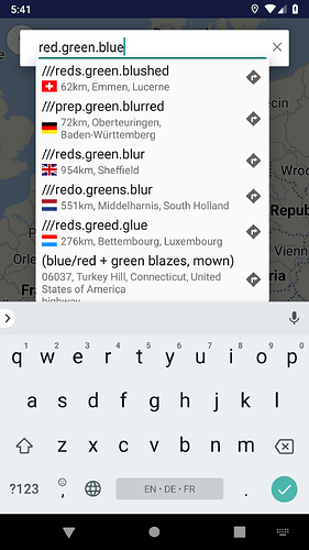
- Geocoding: integration of what3words
You can do forward search to convert 3 word addresses to map positions, via the known Search dialog or if click w3w links.
And can do reverse convert of map positions (via long press) to 3 word addresses, which are copied automatically to clipboard.
- Export: export Garmin ShapingPoint GPX format
There is support for the Garmin ShapingPoint GPX available in export formats.
- Export: remember name of imported file
When import a route file, the following exports remember and propose its name as exported file.
- Export: file overwrite warning
If export a route with a file name that exists, there is a visible warning for possible overwrite, allowing for a rename beforehand.
- Routing: place waypoints on street
- Routing: show whole route
1st action works like in website, snapping the waypoints on the route.
2nd action shows whole route with scroll / zoom the map accordingly.
You’ll find them in the new Actions menu or if long press on route.
- Routing: clear overlay and/or routing
The Clear dialog was enriched, so can select if want to remove the overlays (e.g. GPX) and/or the whole routing from the map.
- Map: zoom with volume keys
You can use the device’s volume keys for zoom the map, available as option in Settings.
We’re looking forward for your feedback about the new version and we wish you a nice Kurviger experience! ![]()
![]()
