nach dem Export meiner Route sieht die Route bzw. die Punkte in der anderen Software anders aus als gedacht. Dann habe ich mal die GPX Datei genauer angeschaut und mir ist folgendes aufgefallen. In meiner Route habe ich ein Zwischenziel und viele Shapingpoints. In der Punkteliste der GPX Datei stehen erst mal viel mehr Punkte drin als ich definiert habe. Da scheint Kurviger noch was zu ergänzen (diese werden dann als waypoint / shaping gekennzeichnet). Das lasse ich mal unkommentiert. Jedoch werden alle Punkte, egal ob in Kuriviger als Shaping oder Zwischenstop angezeigt, als “type=via” ausgegeben, somit kann die 3party Software nicht unterscheiden zwischen Shaping und Zwischenstop. Ist das so gewollt, ist das ein Bug? Weiß da jemand mehr Bescheid?
Ich habe beim Export nur die Option Route aktiviert, eigentlich sollte das passen.
Hallo Zehnerl,
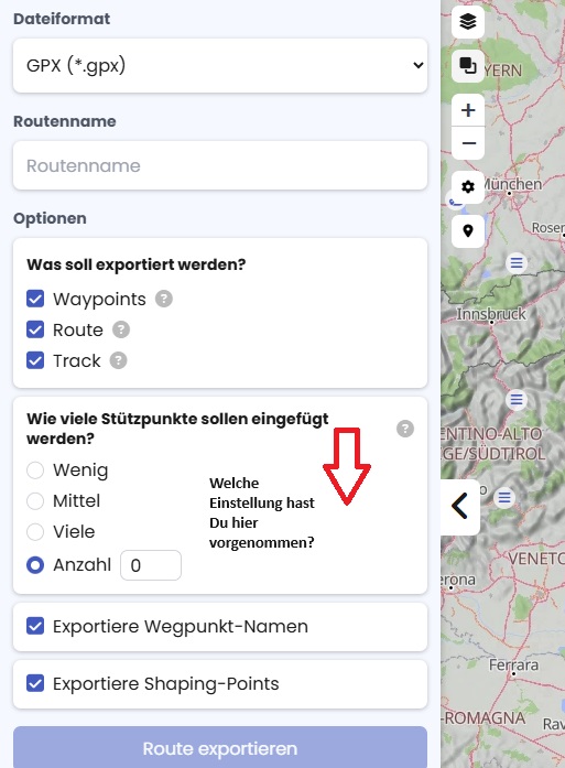
bei Anzahl steht 1500, wobei nicht so viele Punkte in der Datei stehen. Ich habe das gerade mal auf 0 gestellt, dann sind wirklich nur die angezeigten Punkte in der Datei.
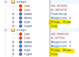
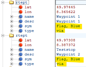
Wir sprechen von Scenic, wobei das eigentlich egal ist. Wie gesagt, es werden die shaping-Punkte und Zwischenziele in der GPX Export Datei beides als “type=via” und “sym=Flag, Blue” gekennzeichnet, wie soll man diese also unterscheiden können?
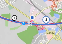
An dieser Stelle haben wir zwei Flags, eine schwarze (Shaping-point) und eine blaue (Zwischenziel). Beide werden in der GPX-Datei mit Symbol “Flag, blue” und type via gekennzeichnet. Aus meiner Sicht rieht das nach einem Bug oder nicht sauber umgesetzt.
Wie das bei Scenic läuft kann ich ehrlich nicht sagen… ich habe aber ein ähnliches Verhalten in der BMW App auch dort kann die App nicht unterscheiden zwischen Via oder Shaping.
Ein anderer user hat aber anscheinend einen Weg gefunden der für mich hilfreich sein könnte.
das ist ein guter Punkt. Die Wegpunktnamen hatte ich aktiviert, nicht aber die Shaping-Punkte. der Sinn hat sich mir nicht erschlossen, da diese ja eigentlich (laut Gui-Beschriftung) schon bei den anderen Optionen dabei sind. Hier ist aus meiner Sicht kurviger unnötig verwirrend.
Mit der Option “Exportiere Shaping-Points” werden die Punkte unterschieden. Zwar werden sie dann bei Scenic, nicht so importiert, aber vielleicht gibt es dort auch wieder eine unnötige Option oder die verstehen das Protokoll anders.
Danke für den Hinweis, damit komme ich weiter und poste mal bei Scenic.
Simple exchange of shaping points between apps is mostly non-existent.
Most of the existing apps recognise the (rtept) routepoints as viapoints.
Excellent bidirectional transfer of shaping points.
Kurviger <=> Cruiser.
.kurviger (track) file.
.gpx rte (route) file.
.gpx wpt (waypoint) file. “gpx waypoints use in a route for calculation purposes are to be regarded as gpx (rtept) route(way)points”
Correct unidirectional transfer of shaping points.
Kurviger => Garmin.
.gpx (rte-route) file (garmin extension).
Cruiser => Garmin.
.gpx (rte-route) file (garmin extension).
Cruiser = > Locus map. (Are imported as Locus “silent” viapoints)
.gpx (trk-track) file. (navigation track)
First a “Wow” from me! It seems to me that you are caring about interoperatiliby of GPX-files?
Perhaps you (or somebody else) can answer my question about the export-parameters?
I made some tests with Export waypoint names = true|false and Export shaping points the same, in sum 4 exports. In all cases all waypoints are in the waypoint list.
The result of flagging Export waypoint names = in gpx the name-tag contains the name of the waypoint (SP and via). I would say as expected, as the button promises.
The result of Export shaping points = The shaping points are also in the waypoint list (I would say not as promised from description of the button).
Instead the value for the symbol-tag is now “Waypoint” instead of “Flag, blue”.
The type-tag contains now the value “shaping” (instead of value “via”).
Note: The description of the button would better be “Export shaping point type”, if it should reflect the result?
Question:
Do you know cases, where the flagging of the above is relevant for a receiving software? When to flag what or when not to flag?
Edit: You listed your known softwares. Means, I should know in forehand, which software is the receiving one. If I am unsure, I should not use “Export shaping points”?
The problem posed has historically arisen as follows.
In the early days…(where have I heard that before).
Or using Garmin mapsource there were only (rtept) route points then used as via points.
With Basecamp (I’m not a Garmin gps user) the distinction was then apparently still introduced
This by specifically designating shaping points in the route points using a Garmin extension.
If the receiving software does not recognise this, each route point then still becomes a via point.
Using Kurviger and the .kurviger file system, this distinction is made anyway.
The .kurviger files are only used and recognised by the Kurviger as well as the Cruiser app.
Kurviger and Cruiser in gpx indicate the distinction very simply into the point type.
If nothing is specified in the point type, it is as originally considered a via point.
A Cruiser gpx navigation track point type shaping imports Locus as a ‘silent’ via point.
So you have in Locus map.
announced via points
muted (silent) via points
App internal shaping points. (Planner and app database).
The Locus app internal shaping points are not transferred in the export Locus gpx file.
They are thus permanently lost in Locus gpx exports and thus not recoverable anymore…
Note.
Of course, if you delete the Kurviger gpx shaping route points, they are also completely lost as via points.
Ok. The compatibility between Kurviger and Cruiser is given as these have a common history.
All other receiving software / their developers decide with their own philosophy how they support which data. Same as Kurviger does not support all Garmin-extensions, as not required.
Ok, this is also my expectation.
The idea of my question was: “Which of those two flags are required? Can one or both be removed?”. Anti-Feature-Request.
Reason: In short time there were two questions auf the Flag “Export Shaping points” - I could not give an answer. Perhaps others know, but did not answer. So I could not give an answer for best practices, or when to use what. I do not expect, that everybody looks into the gpx and says “Ah - wrong flag used.”.
Export waypoint names:
I think the use of this has no technically reason, but privacy reason. Perhaps someone notes private data in the waypoint / shaping-point name and does not want to expose this.
Export shaping points (types)
With this flag the kurviger-shapings-points are exported with type “shaping point”.
I find no good reason, why this information shaping points should be lost. It is just a string-value. If the receiving software wants to use, use. If it does not check for this, it will become a via-point.
From my current knowledge:
Export waypoint names makes sense to me
Label “Export shap…” should be renamed to “Export shaping point type”, or “Export waypoint type” … if required at all in the gpx-export(s)-options and type is shap… is used as default.
A short help/explanation on the buttons would be nice