(Deutscher Text weiter unten!)
Hi everyone,
I often transfer longer routes from Kurviger (GPX export with route + track) with many intermediate points (so that the Navi follows the Kurviger route) to my BMW Navigator 5.
For this I use my Android tablet during motorcycle trips (both for the planning in the Kurviger app and for the transfer to the Nav 5).
Problem: Since the Nav5 can handle only 31 ViaPoints per route (including start and destination), the routes are divided by the Nav 5 in several routes when importing.
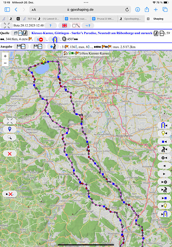
I programmed a tool that converts some of the points in ShapingPoints (often referred to as an intermediate destination without an alarm?) so that only 31 ViaPoints (also often referred to as an intermediate destination with an alarm?) are left over. The new route is downloaded as a GPX in Garmin format.
This is helpful for newer Garmin Navis (Zumo 590, 595, BMW Nav 5, Nav 6). Prerequisite: The Navi must be able to handle ShapingPoints.
The converter is WEB-based (browser), but can also be downloaded locally (extract ZIP to a local folder, then the local html file must be opened with a browser).
It works with a PC, but also with a mobile phone or tablet (WEB and local, I tested only on Android and PC, FireFox and Chrome.) Should theoretically also work with apples, but I can not test).
Some options (number of possible ViaPoints, shaping points, user mode, route preference, color of the Kurviger track etc) are adjustable.
Works also with routes that are not from Kurviger - if a track is in the same GPX, it should correspond to the planned route, as in this case the distance between the route points to each other along the track is calculated to estimate their importance.
Furthermore, you can convert a route calculated by the Navi (GPX in Garmin format) into a track to display it as an overlay in Kurviger - so you can see on the PC / Tablet (the screen is larger than that of the Navi) in Kurviger, where the Navi otherwise calculates and may possibly add intermediate goals.
More information on the converter page:
Help for the converter:
Further background info to the offered options can be found in the old Kurviger forum (Google Group):
https://groups.google.com/forum/#!topic/kurviger/5tTTeGXoNSU
Regards
Markus
===============================================================
Hi zusammen,
ich übertrage häufiger längere Routen aus Kurviger (GPX Export mit Route + Track) mit vielen Stützpunkten (damit das Navi auch die Kurviger-Route fährt) auf meinen BMW Navigator 5.
Dazu nutze ich unterwegs mein Android-Tablet (sowohl für die Planung in der Kurviger-App als auch für die Übertragung zum Nav 5).
Problem: Da der Nav 5 nur 31 ViaPoints / Route kann (inkl. Start und Ziel), werden die Routen beim Import vom Nav 5 in mehrere Routen aufgeteilt.
Ich habe einen Konverter geschrieben, der einen Teil der Punkte in ShapingPoints (auch oft als Zwischenziel ohne Alarm bezeichnet ?) umwandelt, so daß nur 31 ViaPoints (auch oft als Zwischenziel mit Alarm bezeichnet ?) übrig bleiben. Die Route wird dann in ein GPX im Garmin Format ausgegeben.
Hilfreich ist dies für neuere Garmin Navis (Zumo 590, 595, BMW Nav 5, Nav 6). Voraussetzung: Das Navi muß ShapingPoints können.
Das ganze ist WEB-basiert (Browser), kann aber auch lokal runtergeladen werden (ZIP in einen lokalen Ordner entpacken, dann muß die lokale html-Datei mit einem Browser geöffnet werden).
Der Konverter funktioniert mit einem PC, aber auch mit einem Handy oder Tablet (WEB und lokal, ich habe nur unter Android und am PC getestet, FireFox und Chrome. Sollte theoretisch auch mit Äpfeln funktionieren, kann ich aber nicht testen).
Einige Optionen (Zahl der möglichen ViaPoints, ShapingPoints, Benutzermodus, Routenpräferenz, Farbe des Kurviger-Tracks etc) sind einstellbar.
Klappt auch mit Routen, die nicht aus Kurviger kommen - wenn ein Track im selben GPX ist, sollte er der geplanten Route entsprechen, da in dem Fall der Abstand der Routenpunkte zueinander entlang des Tracks errechnet wird, um ihre Bedeutung einzuschätzen.
Weiterhin kann man eine vom Navi berechnete Route (GPX im Garmin Format) in einen Track umwandeln, um diesen als Overlay in Kurviger anzuzeigen - so sieht man auf dem PC / Tablet (der Bildschirm ist größer als der des Navi) in Kurviger, wo das Navi anders rechnet und kann ggf. noch Zwischenziele hinzufügen.
Mehr Infos auf der Konverter-Seite:
Hilfe zum Konverter:
Weitere Hintergründe zu den angebotenen Optionen findet Ihr bei Interesse im alten Kurviger-Forum (Google Gruppe):
https://groups.google.com/forum/#!topic/kurviger/5tTTeGXoNSU
Ciao
Markus
