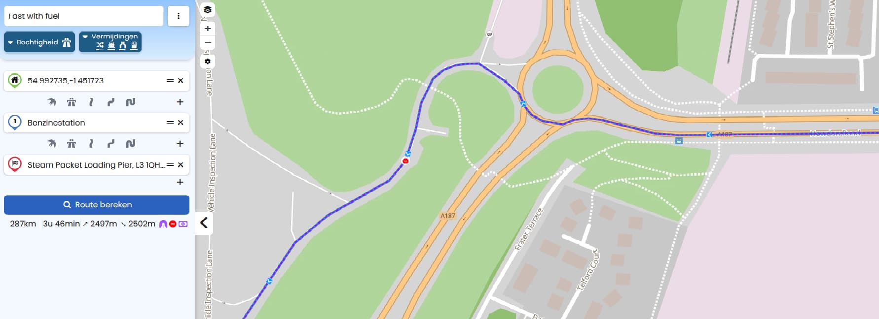
I have planned a route, but the route that is sugegsted has 3 roadblocks, why even suggest this route?
I tried to search in the web interface but no way to remove or replan the route or even negate the blocks.
What use is a planned route if it is just plain wrong.
1 Like
Das Problem hatte ich heute auch.
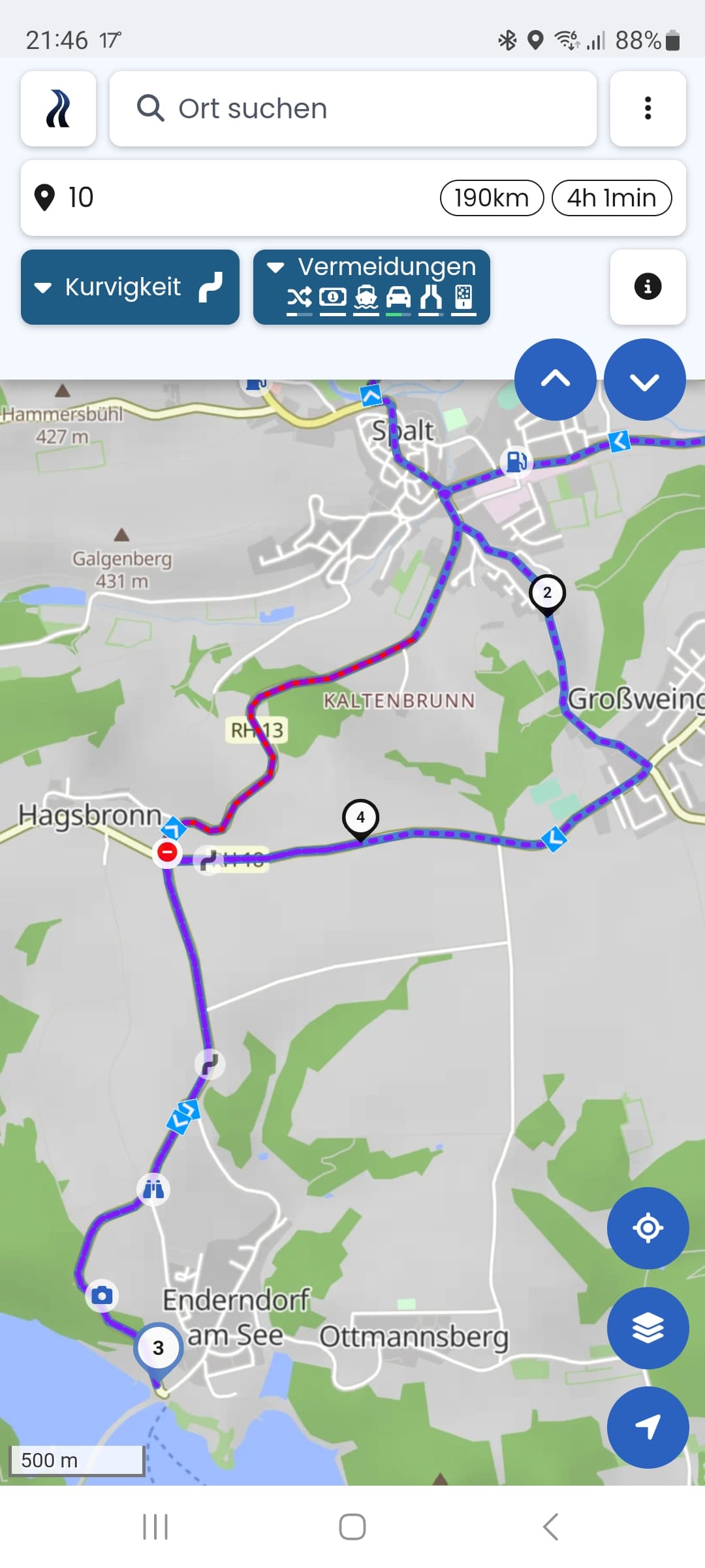
Die geplante Tour zum Zwischenziel enthielt einen gesperrten Bereich. Da ich Ihn mit Shaping points nicht umgehen konnte, habe ich mir vorher und hinterher ein Zwischenziel erstellt, um die Routenführung dorthin zu zwingen. Was aber auch nicht funktioniert hat, weil nach dem Zwischenziel 4 die Anweisung zum Wenden kam und er mich wieder über den gesperrten Teil führen wollte.
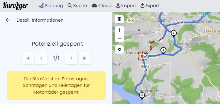
Dass dieser Streckenteil ggf. gesperrt ist, fand ich ja super als Information aus der App. Hätte ich so nicht gewusst. Aber dann wäre es auch gut, wenn man ihn vermeiden könnte ![]()
I’ve no idea why Kurviger takes this silly route with a lift gate:

My solution is setting shaping point (1) in this route: https://kurv.gr/93DSA
Stimmt - fällt wohl in die Kategorie “no-go-area” (in der “to-do-list”).
Aber wenn du die Vermeidung “Mehrfach-Befahrung” ausschaltest und die shaping points (2) und (4) etwas weiter in Fahrtrichtung ziehst, ist das Wenden zu vermeiden:

Habe ich mir das Wochenende auch gewünscht.
Das Beispiel ist echt knifflig. Auf der anderen Seite ein gutes Beispiel, wie Kurviger versucht Ortschaften zu meiden. ![]()
Ich glaube, die Reihenfolge der Punkte 2, 3, und 4 in Deinem Screenshot ist vertauscht.
Wie so oft, wäre es gut, wenn ihr einen Kurzlink hier mit reinkopieren würdet. (Nicht den Link zur GPX sondern die HTTP…
Dann kann man das Problem erst richtig nachvollziehen.
Oft sind es eben solche Reihenfolgen von Punkten oder eben Vermeidungen, die Themen verursachen.
Wäre dann schneller zu beantworten.
2 Likes
See the short link for the route. it indeed sends you to a dropgate/nogo area.
When I tell kruvinger to avoid toll roads it will take another route without this block.
(the toll route in this case is the Thyne tunnel 2, and is free of charge for motorcycles. Maybe something to look into in the future also)
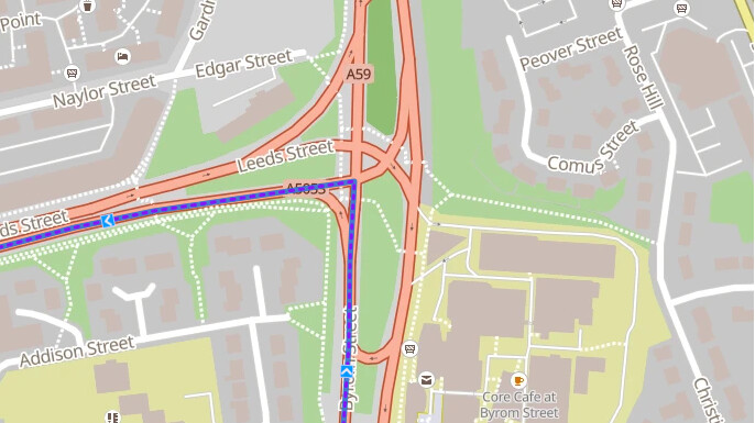
Then we also have other issues in Liverpool where it wants you to take some illlogical routes that could be shorter. (Its tiring enough to be ridinng on the left side of the road.)
Because some closures are seasonal, like a weekend closure. But you might do the tour during the week. Same goes for winter closures, etc.
Ah ja, das sieht man hier auch ganz gut auf deinem Screenshot, die Route geht ja noch durch den gesperrten Bereich. Der SP4 ist vermutlich zu nahe an der Kreuzung.
We allow routing through lift_gates if they don’t explicitly have access=no or similar. There are many lift gates that are mostly open (you might remember hundreds of threads several years ago about this).
Jep, ist auch weiterhin geplant ![]() .
.
That’s probably an issue in the OSM data, there should be a turn restriction here.
Yes, this is a case that we currently don’t handle well. There are a few cases like this.