[BETA] OverlayManager - manage your map overlays | Verwalte deine Overlays

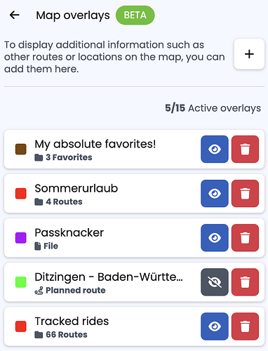
We just launched the OverlayManager on our website - https://kurviger.de/en. This is a completely new way to manage and work with Overlays in Kurviger.

Previously, an Overlay always belonged to one route. Now Overlays stay on Kurviger, independent from the route, they are even synchronised with your Kurviger account, so you can use them on different devices.

What can be shown as an Overlay?

  • Files (e.g. gpx)
  • The currently planned route
  • Cloud Route
  • A favorite folder
  • A route folder (only for Tourer/Tourer+)

You can load multiple overlays and can change the color for every overlay individually, just click on the colourful tile on the left of the name.

We hope you enjoy this new feature and are looking forward to your feedback. We will be adding this feature to the Android and iOS App soon, so stay tuned :racing_car: :motorcycle:.


Wir haben gerade den OverlayManager auf unserer Website veröffentlicht – https://kurviger.de. Dies ist eine völlig neue Möglichkeit, Overlays in Kurviger zu verwalten und damit zu arbeiten.

Bisher gehörte ein Overlay immer zu einer Route. Jetzt bleiben Overlays auf Kurviger, unabhÀngig von der Route, sie werden sogar mit deinem Kurviger-Konto synchronisiert, sodass du sie auf verschiedenen GerÀten verwenden kannst.

Was kann als Overlay angezeigt werden?

  • Dateien (z. B. gpx)
  • Die aktuell geplante Route
  • Cloud Route
  • Einen Favoriten-Ordner
  • Ein Routen-Ordner (nur fĂŒr Tourer/Tourer+)

Du kannst mehrere Overlays laden und die Farbe fĂŒr jedes Overlay einzeln Ă€ndern, indem du auf die farbige Kachel links neben dem Namen klickst.

Wir hoffen, dass euch diese neue Funktion gefÀllt, und freuen uns auf euer Feedback. Wir werden diese Funktion bald auch in die Android- und iOS-App integrieren :racing_car: :motorcycle:.

14 Likes

Hallo Robin.

Heute morgen schon ausprobiert. Noch bevor der Kaffee ausgetrunken war. :coffee: Das zeigt dass es auch ohne Koffein super funktioniert. :yawning_face: Ich liebe diese Funktion. Das war 1 von den 2 Dingen auf die ich dringend gewartet habe.

Jetzt fehlt mir nur noch die Funktion dass ich ich beim managen mehrere oder alle Dateien auf einmal anklicken kann um sie zu verschieben/löschen/anzeigen. Wobei anzeigen geht ja jetzt im Layer :blue_heart:.

3 Likes

Thanks!
The new system helps a bit with charging stations. However, I still run into a problem with trying to show me all the type 2 sockets in Germany.
The extracted gpx-file from POI Generator - Stromtankstellen fĂŒr NavigationsgerĂ€te is too big. I don’t know if the number of points is too big or the amount of information stored in the files.
File size is 6’191’954 Bytes. Probably the first one (File size exceeds the maximum limit 
).

I’m still eagerly waiting for charging stations being implemented as POI genuinely 


2 Likes

Vielen Dank fĂŒr die kontinuierliche Weiterentwicklung.
Der OverlayManager ist prinzipiell sehr nĂŒtzlich. Leider scheinen ein paar Features verloren gegangen zu sein (ich beziehe mich folgend auf den Desktop).

  1. Man kann nicht mehr auswÀhlen, welche Informationen beim Laden aus einer Datei verwendet werden. Das beiliegende GPX ist aus BMW Connected Ride exportiert, und enthÀlt Routen- und Trackinfos. Es werden beide geladen, wobei die Routenpunkte direkt verbunden werden. Das ist wenig hilfreich.
    Connected_test.gpx (21.5 KB)

  2. Sind mehrere Browser-Tabs (Chrome) mit kurviger geöffnet, dann werden Änderungen an den Overlays auf alle Tabs angewandt. Schön wĂ€re es schon, wenn jeder Tab seine privaten Overlays haben könnte.
    Korrektur: Die Liste der Overlays ist synchronisiert (finde ich gut), die Auswahl eingeblendet/ausgeblendet ist privat. Damit ziehe ich diesen Punkt zurĂŒck, sorry.

Darf ich noch einen Vorschlag zur Beschriftung der neuen Buttons einbringen?

  1. “Overlay auf der Karte verstecken” → “Overlay ausblenden” entsprechend “Overlay einblenden”

  2. “Overlay löschen” → “Overlay entfernen”

Wie kann ich diese Funktion öffnen und wie kann ich sie finden

Bitteschön :wink:

Yeah, it could be either. You can try to split the file into multiple files. The limit for points per file is currently at 10k. You can import more with multiple overlays. But please note, at 10k+, Kurviger might become a bit slower/sluggish.

Ja genau, das ist aktuell noch ein Problem des neuen OverlayManagers.

Danke fĂŒr den Hinweis :+1:.

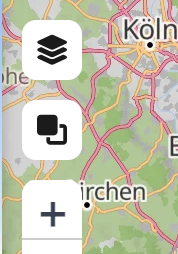
Aktuell ist die Funktion nur fĂŒr die Webseite verfĂŒgbar, die App erhĂ€lt diese Funktion dann mit dem nĂ€chsten Update. Auf der Karte gibt es einen neuen Button:

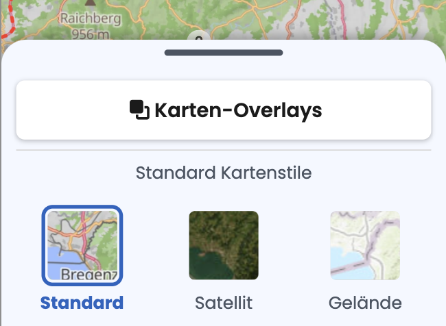
In der mobilen Version findest du das im MenĂŒ fĂŒr die Karten:

1 Like

Well yes. These charging stations where > 26k points.
I managed to divide them into three different files with Garmin BaseCamp. Unfortunatley I cannot sort them geographically before dividing them (only alphabetically).
Which means, that I have to activate all three of them in Kurviger when I plan a tour - which makes the website very slow/sluggish, as you mentioned.

1 Like

I also ride an electric motorcycle and have the same thoughts as you. The following worked for me:

  • export the POIs from GoingElectric
  • then convert the GPX file to xlsx (e.g. with mygeodata.cloud)
  • sort by lon and lat and delete areas that are not needed
  • then create 3 files (north, middle, south) - so that the number of points is reduced accordingly
  • then convert them back to GPX (with the tool mentioned above)
    mygeodata.cloud is free for 3 conversions per month.
1 Like

Wouldn’t it a good idea to share these files for other “electric bikers”?
Btw: not for me - I’m to old for this stuff. :roll_eyes: :wink:

2 Likes

Here we go:
Typ 2 >= 11 kW
Germany only
accessible 24/7
charging cards: MAINGAU + EnBW

GoingElectric_-_Germany_only_South.gpx (1.5 MB)
GoingElectric_-_Germany_only_Mid.gpx (1.4 MB)
GoingElectric_-_Germany_only_North.gpx (1.5 MB)

4 Likes

Aaaha - danke schön :+1:t3:

Feedback zum neuen Feature:
Wieder ein Schritt weiter 
, kurviger wird 
 :trophy: :medal_sports:
ihr macht das super!!!
Wenn ich die Favoriten als neues overlay fĂŒr eine bestimmte Tour lade, sind die gleichen geladenen favoriten aber auch bei einer anderen tour geladen.
da muss ich sie dann löschen (papierkorbsymbol) und die favoriten der neu geladenen tour dann laden. auch ein hin- und her 

ich hÀtte gerne, dass die geladenen favoriten in der dazu gehörend geladenen tour bleiben!

1 Like

Thanks!
As I have EnBW and Shell (and others), but not Maingau I found another way, after reading your solution and a bit of thinking.

  • I also did an export from GoingEelectric according to my preferences
  • converted the GPX to CSV using https://www.gpsbabel.org/ which is a completely free tool (I remembered having such a tool).
  • After that the same as you, but using gpsbabel again for reconverting.

Using gpsbabel gives the freedom of using conversions as often as needed without cost.

I think using GoingElectric is good for Germany and Switzerland. Other european countries?
I don’t know. Charging stations in France are missing in GoingElectric regularly. (Most of the time).

Die Overlays sind unabhĂ€ngig von der Tour. Du kannst aber ĂŒber den Sichtbarkeits-Knopf die Sichtbarkeit verschiedener Overalys schnell wechseln. Papierkorb wĂŒrde ich eher nicht empfehlen, wenn du das Overlay bald wieder brauchst, da das löschen sich auf alle GerĂ€te bezieht, Sichtbarkeit ist nur lokal.

1 Like

This is a nice ‘enhancement’ and I can’t wait until the overlay manager makes it to the Android app.
Would be nice, I think, if you can share a route including overlays with POI’s, or what would be the workflow to share an overlay with POI’s otherwise?

Thanks for keeping developing Kurviger!

I really like that enhancement :+1: :+1: :+1:!

Just a question: Is it possible to switch off clustering of overlay waypoints?
Switching off POI clustering seems to have no influence on overlay waypoints.

1 Like

Ichhab nur kurz Zeit gehabt den Overlay Manager anzuschauen. Genau das hat mir gefehlt. Nur noch auf der App implementieren, dann sind TET, ACT, geplante vs aktuelle Route usw. Perfekt zu handhaben.
Eine Frage: wenn ich alle gefahrenen Routen als Overlay einbinde, wird das Overlay dann automatisch erweitert, wenn eine Aufzeichnung dazu kommt? Das wĂ€re speziell in der App dann ein großer Vorteil.

This is currently not possible, you’d have to share the GPX for the overlay + route. This is something we are looking into in the future.

Currently not, we are currently looking into possible improvements for this. Clustering is crucial when you have a lot of points, otherwise there will be serious performance degradation.

Ja genau, das wird automatisch aktualisiert.

1 Like

hello ne peut pas avoir une fonction dans l ’ importation pour sĂ©lectionner dans l ‘overlay uniquement la trace , comme avant , c’ Ă©tait ideal pour le partage de fichier avec des amis , et je ne comprend pas trĂšs bien l ’ utilisation des lignes droite qui surcharge l ’ Overlay