Is indeed the same request. But there has been no movement on the topic anymore. Sadly
Many features await the attention of the single developer.
Please be patient, we will see what can be done in future.
Also could be combined with:
3 Likes
Single Developer - I know. Tough work!
The “next fueling station” function derived by calimoto should be implemented into kurviger soon. The only thing that is missing by now in my opinion. But I don’t know how much programming work this will be ![]()
![]()
2 Likes
Daß seit zwei Jahren für dieses Feature nichts geschehen ist, ist eigentlich ein NOGO!
Bitte Kurviger.de Team . . . eine Click/Click Lösung für [ Nächstgelegene Tankstelle ] einarbeiten.
Bei den modernen Motorrädern mit den kleinen Tanks extrem wichtig.
Aus diesem Grunde benutzte ich parallel Calimoto . . . mit zwei Clicks kann man die Tour erweitern, zur nächstgelegenen Tankstelle. In den Bergen z.B. wo man ja keine Adresse von einer Tankstelle kennt extrem wichtig
1 Like
Ich füge meine Tankstops schon bei der Planung ein und gut is.
1 Like
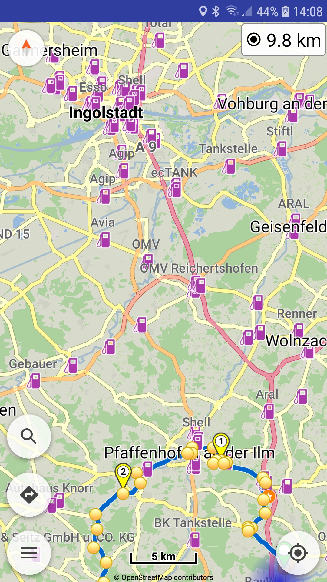
View of gas stations in Kurviger app
Zoom to the one you like, long press on one, and add as waypoint.
4 Likes
GraphHopper search does not support searching along route lines (only inside bounds).
So something else is needed to find the POI and then use them in navigation.
1 Like
Bitte… be fair! Don’t forget that a lot of new (more or less essential) functions have arrived. During this time @devemux86 did not even for a moment stop working on improving our favorite Kurviger, and it does it with great consistency, teaching us patience ![]()
7 Likes
That is your solution. Please respect that others so not find this a workable solution. Thanks
naja - auch 'ne Lösung!
Ich mache es wie linux-user App: Navigation nearby POI - #27 by linux-user - glaub’ mir: es funktioniert!
1 Like
Ja! diese Lösung habe ich inzwischen auf gefunden . . . nachdem ich in einem Forum die Lösung gelesen habe: Offline Karten laden . . . erst dann kann man in der Kartenebene die Tankstellen high lighten. Man muß viel lesen und suchen . . . aber nur als Neueinsteiger ![]()
Yes! I found this solution too in the meantime. . . after reading the solution in a forum: load offline maps. . . only then can you highlight the gas stations in the map level.
You have to read and search for a long time . . . ![]()
![]()
![]()
Ja! diese Lösung habe ich inzwischen auf gefunden . . . nachdem ich in einem Forum die Lösung gelesen habe: Offline Karten laden . . . erst dann kann man in der Kartenebene die Tankstellen high lighten. Man muß lange lesen und suchen . . .
Yes! I found this solution too in the meantime. . . after reading the solution in a forum: load offline maps. . . only then can you highlight the gas stations in the map level. You have to read and search for a long time . . .
DE: (EN see below)
Manchmal hilft es auch, den direkten Weg über die Kurviger Dokumentation zu wählen ![]() . Hier z.B. der Link in die Doku zur Lösung deines Problems:
. Hier z.B. der Link in die Doku zur Lösung deines Problems:
https://docs.kurviger.de/de/app/manual/map#poi_tankstellen_usw_aus_kartendaten
EN:
Sometimes it helps, to take the direct way to the Kurviger documentation ![]() . Here e.g. the link to the docu for solving your issue:
. Here e.g. the link to the docu for solving your issue:
https://docs.kurviger.de/app/manual/map#poi_fuel_stations_etc_from_map_data
2 Likes
Ja! der Weg über die Kurviger Dokumentation hilft ! ![]()
![]()
![]()
Inzwischen habe ich mich in Kurviger.de eingefuchst . . . ein tolles Tool !!
Ich werde es lieben und bin schon mal begeistert - habe alle Sommer Touren 2022 schon umgestellt.
Mal sehen, ob ich es schaffe im Ducati Club hier, die Leute von Calimoto zum Kurviger.de “rüberzuziehen” ![]()
2 Likes
Just try to go off road… with calimoto impossible
Hi all,
I’m just back from 2 weeks enjoying motorbiking in France and Spain.
We were a team of 4 bikers - 2 of us were using Kurviger app (pro version), 1 using a TomTom.
I was one of the Kurviger-Pros and I was really happy to have this app. It was perfect to plan the trip for the next day, sharing the tour with the other Kurviger-Pro via QR-Code, routing during the trip. The little time needed to plan a route of 1800Km … This was really impressive compared to my experience with my old Garmin Zumo XT.
I would say there was just 1 thing where the TomTom had an advantage:
When the petrol level reaches the reserve then with Kurviger app you often need to stop and search where the next petrol station is. Of course the petrol stations are shown as POIs on the map. But you do not know the distance. If you have several POIs on the map then you need to decide which petrol station to choose. Or if you are in the mountains then often there is the question do I need to take this petrol station already or may we take the next one?
Only if you selcet one POI and add it to the route then you can see the distance.
TomTom has a feature where it shows the distance to the next petrol station which is directly on the track without being already a waypoint. So when your bike indicates that petrol is almost empty (maybe 50 Km still to go) you can see if a petrol station on the route will be reached before - and also next petrol stations on the route. It would be great if Kurviger app could always show next to distance to target also the distance to the next petrol station on the route.
It would be even better if with a long press on that information a pop-up window would appear with a list of the next petrol stations. It would be great if you could select one and by doing so either add it as a waypoint or getting more information about the POI (phone number, web address). Then you could check/call on Sundays or public holidays if the petrol station is open or closed.
Best Regards
Karsten
1 Like
Welcome to Kurviger and thanks for the suggestion.
Something similar is planned for the future.
When the technical details are resolved, as currently no such data is automatically available.
(see the above discussion)