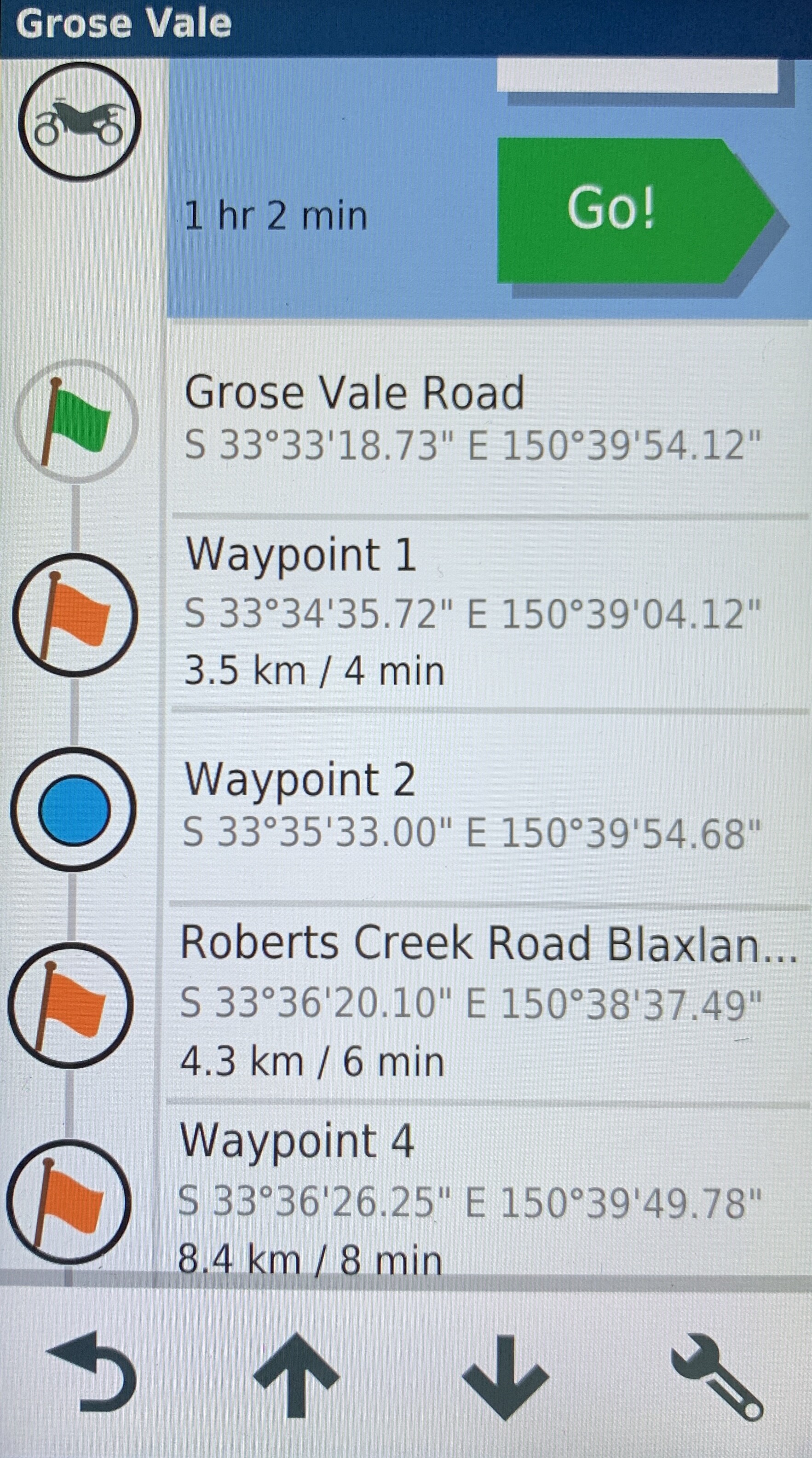
Here’s the GPX markup from a Kurviger website route and the Garmin imported result.
You can see the names “Waypoint X” output and there display on Garmin. You can also see the coordinates have been converted (my Garmin style).
To the end user this doesn’t mean much. If I send a screen shot to my ride buddies they have no idea where I’m going especially if a long trip and I’m displaying the entire route on screen.
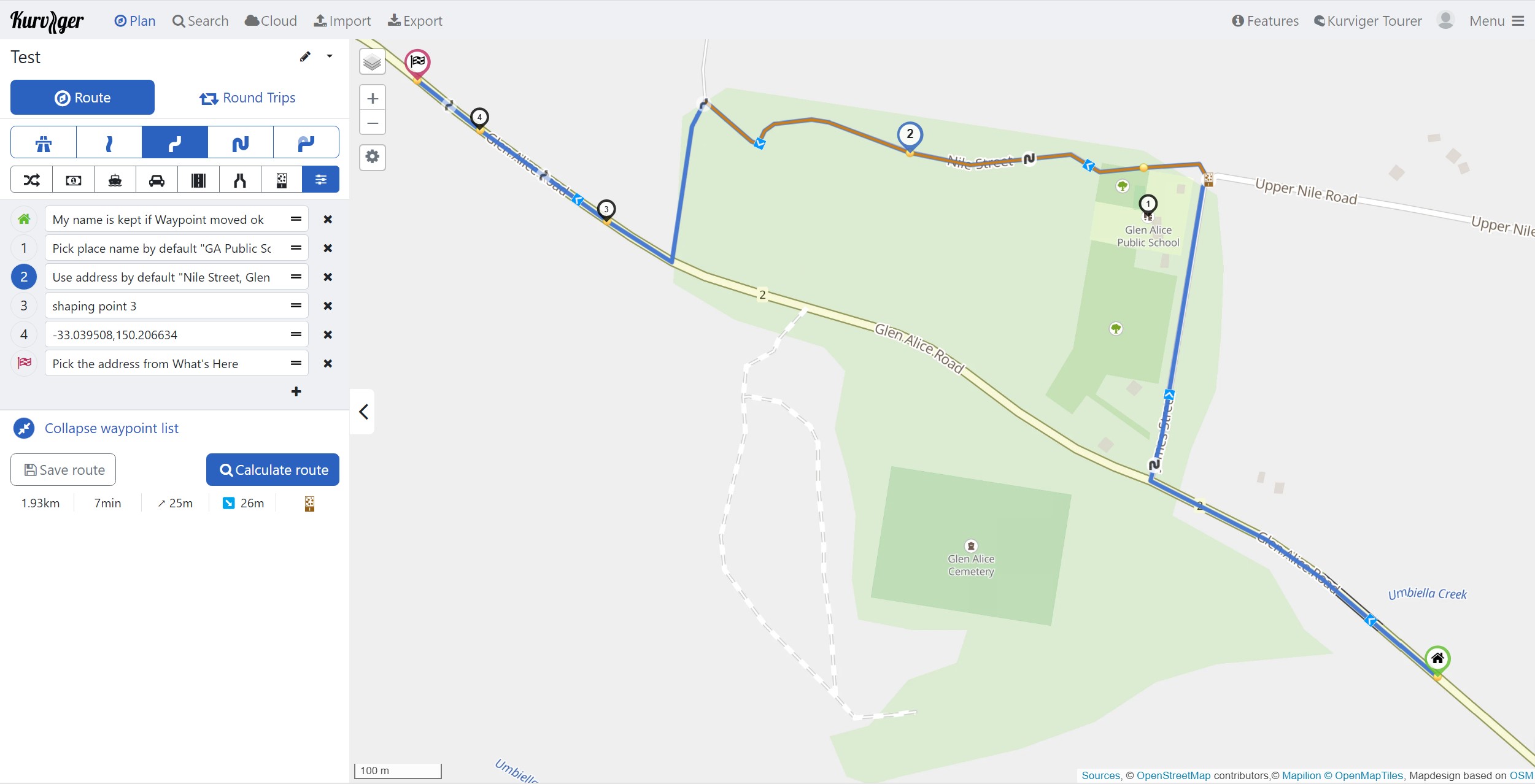
If I plan a trip on the Garmin it will name it as per the address or street or town.
I understand that despite the displayed names the navigation engine will generate turn by turn instructions with road names. However, I would really like to see location names (as per the What’s Here dialog) in the display and the voice dialogue as it can quickly remind me of the route places I have marked. True I can insert them but I’m inserting 100 of them and usually I copy and paste the What’s Here data.
If I’m approaching a gnarly river crossing and I want to skip it then it is much easier for me to know that Strops Crossing is coming up and decide to pass rather than 33.607286, 150.66383 or Waypoint 13 - where is that ? Or my Ride buddies can see Strops Crossing in my trip plan and discuss whether it should be tackled or not !
For the users who say it doesn’t matter to them then by deduction it doesn’t matter if the place name is automatically inserted or any random string. They don’t mind  . If the “doesn’t matter to me” voice influences the priorities that the development team follow then that’s well and good as the most deserved modifications get done.
As to the matter that the What’s Here dialog sometimes generates incorrect information then my view is that is is always up the user to ensure the right information is present whether that be Place Name or GPS Coordinated or Point on the map.
<wpt lat="-33.555202" lon="150.665032"><name>Grose Vale Road</name>
<desc>Continue onto Grose Vale Road</desc><sym>Flag, Green</sym>
<type>start</type></wpt>

<wpt lat="-33.576589" lon="150.65114"><name>Waypoint 1</name>
<desc>Waypoint 1</desc><sym>Flag, Blue</sym>
<type>via</type></wpt>

<wpt lat="-33.5925" lon="150.665192"><name>Waypoint 2</name>
<desc>Waypoint 2</desc><sym>Flag, Blue</sym>
<type>via</type></wpt>

<wpt lat="-33.605584" lon="150.643739"><name>Roberts Creek Road Blaxland</name>
<desc>Waypoint 3</desc>
<sym>Flag, Blue</sym><type>via</type></wpt>
<rtept lat="-33.555202" lon="150.665032">
<name>Grose Vale Road</name><desc>Continue onto Grose Vale Road</desc>
<sym>Flag, Green</sym>
<extensions><trp:ViaPoint><trp:CalculationMode>FasterTime
</trp:CalculationMode></trp:ViaPoint></extensions></rtept>

<rtept lat="-33.576589" lon="150.65114"><name>Waypoint 1</name>
<desc>Waypoint 1</desc><sym>Flag, Blue</sym>

<extensions><trp:ViaPoint><trp:CalculationMode>FasterTime</trp:CalculationMode>
</trp:ViaPoint></extensions></rtept>
…
<rtept lat="-33.605584" lon="150.643739">
<name>Roberts Creek Road</name><desc>Waypoint 3</desc>
<sym>Flag, Blue</sym><extensions><trp:ViaPoint>
<trp:CalculationMode>FasterTime</trp:CalculationMode>
</trp:ViaPoint></extensions></rtept>
Be well
OME