Hello. Can anybody help me explain why in the middle of a lane Kurviger decides to turn back? (See screenshot attached.) How can I persuade it to route through the shaping points I am adding? Thanks.

According to OSM data, bicycles and horses are allowed, motorcycles are not.
bicycle yes
designation restricted_byway
foot yes
highway track
horse yes
motor_vehicle no
Name Rookwood Lane
source:name OS_OpenData_StreetView
1 Like
By changing the information in OSM accordingly - if there are no prohibition signs against it.
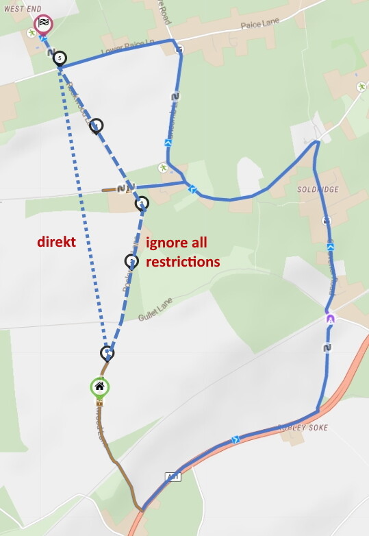
It would still be great if kurviger offers a new routing option “direct” or “ignore all restrictions” between two waypoints and you may decide on your responsibility to take them.
2 Likes
An router example: The RouteYou Planner has both of them available.
By profile
- Manually (direct)
- Shortest - OSM (ignore all restrictions)
2 Likes
yes, to have that option would be very nice indeed. (At the moment I do not know whether there actually are no-go signs on that bit, it seems peculiar though that the permissions on that lane change midway through it.)
(By the way, Scenic accepted the route, clearly does not use OSM. Not sure about MyRoute-App.)
From the description in OSM (Grade 5, mud) that could be a real tough “road” - have fun! 
ha ha, where did you find that description?
Probably in OSM, of course ![]()
If you look at Rookwood Lane on Google Earth you will see that it is a trail (trampling path).
where in OSM? cant find it
