“Straight line” profile can be implemented after and as part of “multiple profiles” feature:
[de] Das Problem mit unbefestigten Strassen haben schon viele hier geäußert. Die Antwort war bisher immer, dass kurviger nur “legale” Strassen routet. Aber das funktioniert nicht immer. Ich fuhr letzte Woche zum Beispiel auch den TET (trans euro trail) von Schwerin nach Lübeck. Ich hatte den Track, ja klar, aber mit kurviger kann die Strecke nicht geplant werden. Es wird einfach nicht dort entlang geroutet, obwohl alle Wege legal zu befahren sind.
Mein Vorschlag: Schafft doch neben dem Motorrad- (KFZ-) Profil auch ein Fahrrad-Profil. Damit wären dann alle Wege erlaubt, die auch mit dem Fahrrad befahren werden dürfen (Autobahnen und Schnellstraßen wären dann natürlich verboten).
Vielleicht käme man so aus der rechtlichen Nummer raus.
[en] The problem with unpaved roads has been mentioned by many here. The answer has always been that kurviger roads only route “legal” roads. But this does not always work. Last week, for example, I drove the TET (trans euro trail) from Schwerin to Lübeck. I had the track, sure, but with kurviger you can’t plan the route. It just doesn’t get routed that way, although all tracks are legal to drive on.
My suggestion: Creates nevertheless beside the motorcycle (KFZ) profile also a bicycle profile. This would allow all ways which can be used by bicycle (motorways and highways would be forbidden).
Maybe this would get you out of the legal number.
Hallo Georg, wenn Du bei Routenberechnung nur BRouter einstellst und diesen mit dem Profil Trekking oder Enduro nutzt müsste die TET zufahren sein, oder? Hast Du das mal probiert?
Also das Problem ist, dass die OSM Daten in dem Bereich oftmals nicht gepflegt sind, da hilft nur, Fehler verbessern, meist sind es gar nicht so viele Probleme.
Ein Fahrradmodus oder ähnliches halte ich für nicht sinnvoll. Es geht ja nicht um die rechtliche Nummer, sondern, bei einem Fahrradmodus kommen keine Routen raus die man als Motorrad-Fahrer fahren darf. Für TET und ähnliches müssen wir mal schauen was wir da machen können. Da soll es schon mal eine Lösung geben - wie die aussieht kann ich aktuell aber noch nicht 100% sagen. Ich würde eigentlich einen Enduro-Modus besser finden als ein Fahrrad-Modus. Wie sinnvoll sich das umsetzten lässt muss man sich aber im Detail anschauen.
1 Like
Nein luckytown, das mit BRouter ist mir zu kompliziert. Ich habe aber kein Problem, einen Track nachzufahren, das geht schon. Nachteil ist aber eben, dass erst einmal ein Track da sein muss. Und den kann ich mit kurviger nicht erstellen.
No luckytown, the BRouter thing is too complicated for me. But I have no problem to follow a track, I can do it. But the disadvantage is that there has to be a track first. And I can’t create it with kurviger.
Ja, und? Steht denn auf ewig fest, dass kurviger nur für Motorradfahrer da ist? Wenn ich als Motorradfahrer so eine Fahrrad-Route fahren würde, läge es ja sowieso immer in meiner Verantwortung, verbotene Wege nicht zu fahren.
Yeah, so? Does it say forever that kurviger is just for motorcyclists? If as a motorcyclist I would ride such a bicycle route, it would always be my responsibility anyway not to take forbidden paths.
Ne, das sagt ja auch niemand, aber einen Fahrrad-Modus einzubauen, damit man mit dem Motorrad frei über jeden Feldweg und Trampelpfad fahren kann halte ich nicht für Zielführend.
Eventuell kann man den Motorradmodus etwas freier gestalten.
Ein Fahrradmodus würde aber z.B. auch Fußwege, Treppen, etc. verwenden, das will man ja z.B. gar nicht (außer vielleicht mit einer Trial-Maschine).
Ja, das sehe ich ein. Vor allem auch, weil dann Leute “verbotene” Wege fahren würden und sich dabei auf das Routing von Kurviger beziehen. Das kann es auch nicht sein.
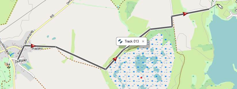
Mir kam eine Idee: Wie wäre es, wenn ich die Möglichkeit hätte, einen (nicht routingfähigen)Track anzulegen. Dann könnte ich mir mit Hilfe der Karte einen Weg festlegen, der sich nicht an Strassen orientiert, sondern nur von Wegpunkt zu Wegpunkt eine Linie zieht. Der Wegpunkt bräuchte nicht nummeriert werden, und er sollte auch nur ein kleiner Punkt auf der Linie sein, der jedoch verschiebbar wäre. Hier ein Beispiel (mit Basecamp gemacht)
Ich sehe gerade, dass die “Luftlinen”-Umschaltung (wie etwa beim ehrwürdigen Motoplaner) schon Thema waren und sind. Tja…
[en]
Yeah, I can see that. Especially also because then people would be driving “forbidden” routes and would refer to the routing of Kurviger. That can’t be it either.
I had an idea: What if I had the possibility to create a (non-routable) track. Then I could use the map to define a route that is not oriented on roads, but only draws a line from waypoint to waypoint. The waypoint would not need to be numbered, and it should also be a small point on the line, but it would be movable. Here an example (made with Basecamp)
I can just see that the “Luftlinen” switchover (like the venerable Motoplaner) was and is already a topic. Well…
Ja genau, dieses Feature steht auch weiterhin auf der todo Liste :). Das halte ich auch für sehr sinnvoll.
You already are on the feature topic, also there is another one for the app.
And they would need other features to be implemented first (app, website).
Please be patient, we cannot offer ETA, with so much work already done.
But app not only has route planning like Motoplaner but also navigation.
Straight lines in navigation? I have to think carefully if that is possible…
Ich hole das mal wieder hoch…
I push this once again…
This seems to be really a poor topic 


 .
.
Already flagged in '20 and probably even before and (as far as I saw) no real news from the programmers side on this very use- and helpful demand and function, having in certain situations the possibility to enter a “poin to point” navigation or a “Luftline”.
Unfortunately even my paid version didn’t have it so far 
Although I’m not very familar programming this I assume on the other hand that it could not be that difficult since the “passed motoplanner” had this great function already in.
I really miss this feature and several times I receive total confused maps because of a couple of hundred meters or some kilometers where there are some issues in the OSM data, and the road/track is not seeing as beeing routable, although I know that it is.
So are there any news and feedback from programmers side - What is the status so far in 08/21. I’m really looking for it. 
Cheers, Dirk
1 Like
When there is news, we will announce it.
Features are not implemented on their own.
You should be patient…
But do not expect it to solve all routing problems:
(and can not be used in navigation)
Bei einem Navi steht das Routing an erster Stelle.
Ob ein Icon links, rechts, größer, kleiner, blau, rot sein sollte oder
die Zoomstufe, die Schrift kleiner oder größer besser wäre……………
Das kann man ändern wenn man Langeweile hat, wichtig ist das Routing, navigieren……
Everyone has different priorities…
(especially if it can be solved better otherwise)
With just 10 votes, it is definitely not a popular feature…
… plus 8 votes for the same feature in the APP.
And the next highest vote count for any feature is 2 … as far as I see.
I do not look at votes in development.
The most voted feature was the offline routing.
(nowhere to be seen)
Hello friends of kuviger,
Keep cool and more patient. All of the
Wishes can’t be developed in short time.
Also take in your mind, there is one developer for the App and one for the website. In the country emux live, the people’s have real problems and not only luxury problems like “there is a wrong blocked street”
Please be more patient and polite to the developers of our favorite App. You all know, kurviger is the best (and cheapest) available navigation app for motorcycle.
Cheers
7 Likes
Thanks everyone for providing valuable feedback  . This feature has been implemented on the Website.
Please let us know what you think about it and how it works for you.
This will be very helpful in planning a route that has a bridge or ferry that connects a road and the map used does not (yet) recognize its existence.
1 Like