Thanks a lot for the feedback!
TomTom with their ITN format have something like this. They have waypoints and stop-overs.
Thanks a lot for the feedback!
TomTom with their ITN format have something like this. They have waypoints and stop-overs.
Can see ITN specification here:
Hi,
as Robin already mentioned the GPX specification contains a symbol tag (<sym>) for route points (<rtept>).
But as far as I can see at least Garmin devices do not care about the symbol ouf route points - newer devices use an orange flag for ViaPoints and a gray-blue circle for ShapingPoints.
Nevertheless the symbol might be a way to store any information for re-import to kurviger or for use in other programs ( e.g. my converter).
Furthermore adding different symbols for this several point types will help on navigation devices which use the symbol tag (<sym>) of route points and display it on the map.
My personal opinion: I would like to be able to see also in navigation device the information, if a route point was a waypoint or a shaping point in kurviger, furthermore I would like to see the name given to a waypoint or a kurviger shaping point.
Therefore I propose to add a hint at the routepoint name for that: For example ‘WP4’ for the 4th waypoint and a ‘FP7’ for the 7th shaping point. So If I have added a 4th Waypoint with the name ‘Lunch’ in kurviger, the name in the GPX would be ‘WP4 Lunch’.
It could be discussed, if the name prefix for shaping points should be ‘FP’ for german variant (Formpunkt).
I just checked: The app uses “Formpunkt” in german version, the website uses “Shaping-Point” in german version - perhaps it would be good to use the same terms in app and website (shall I add a seperate topic for that ?). In that case I would prefer to use “shaping-point” and - of course - the prefix ‘SP7’ in all language versions.
I think the name of the route point can be seen in any navigation device - therefore putting that suffixes to the name works on all navigation devices, so you can see if a point is a waypoint, a shaping point or if it has been added by the GPX export.
This prefixes might be also useful for Garmin-specific GPX export, even, if waypoints are converted to Garmin ViaPoints.
Reason: See if the Garmin ShapingPoints are Kurviger shaping-points (grey marker in app, smaller black marker on website) ore are points added by GPX export. Furthermore when re-importing GPX to kurviger this information also will be useful.
Regards
Markus
Names are set by users and they expect them to remain unchanged, not modified by applications.
Then also turn instructions and navigation will start to show and speak such strange abbreviations.
The order and type of waypoints are processed and should be rendered by apps (N prefix or icon).
Please create a new topic.
Might be right for some users - but currently the names given to waypoints and kurviger shaping points are completely lost in online GPX export, they are set to ‘WPx’, x = 1, 2, 3, …
No - the prefix should be added only to waypoints and kurviger shaping points - turn instructions do not get a prefix.
Online export of waypoint names / types is discussed here,
so obviously it’s not implemented yet. ![]()
Waypoint names currently are supported in app’s offline GPX export.
There are turn instructions on waypoints too, so their names should be unmodified.
Or else at each import / export there will be added new prefixes (WPx WPx WPx…).
It is each app’s responsibility to add custom prefixes in its panels (if they’re needed).
Yes exactly this is the idea.
This will be added in the future ![]() .
.
This is an interesting idea, maybe the name is not the perfect place for this but maybe we could put it into the cmt or desc field of the GPX?
In my Navigator 5 also ‘cmt’ and ‘desc’ of route points are ignored. It seems to use only the name, the coordinates and the point type (in extension: ViaPoint / ShapingPoint ).
I guess all newer Garmin devices are doing so - perhaps users of Zumo 59x, Zumo 39x, Zumo XL etc. can give further information here …
That was the reason for my proposal to put a hint in the name - it is the only item I can see on device.
HI Markus.
A constant factor in applications with gpx is that there is almost no uniformity in applications.
Much of what is possible with the basic gpx standard is unfortunately sometimes not used.
Question:
Do you mean the Kurviger gpx export direct transfer to your Navigator device?
Or the Kurviger output always runs through the converter tool first?
The last:
If Kurviger gpx clearly indicates both Via or Shape by means of type the tool probably can 100% accurately convert such into the typical “in house” Garmin extension?
If Kurviger gpx puts extra info in or cmt or desc, your tool development may be able to convert into the name tag?
No?
Hi Willy,
my proposal was for direct use (without converter), I think most people using Kurviger GPX on a Garmin or an other navigation device do not use the converter.
You are right: Probably the converter will be able to read the information in the ‘cmt’, ‘desc’ or ‘sym’ also, that is no rocket science (but not yet implemented, of course).
Currently you can select a combination of .GPX and .kurviger files to get all information as described in last paragraph in
Regards Markus
The export offers 2 GPX formats:
Sorry, my reply lead to misunderstanding → I expanded “Garmin” by “or an other navigation device”.
But I think it is a good idea to add type prefix in Garmin ShapingPoint GPX.
I do not know how other devices handle ‘sym’, ‘desc’ or ‘comment’ entries - perhaps a TomTom user or a user of an other navigation device can check that.
But I am sure that they show the name - so a name prefix will be shown.
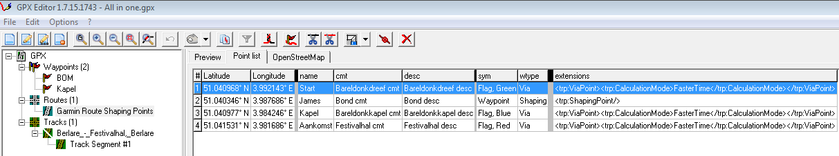
In Garmin Shaping point gpx route export both Start AND Finish by the extension are Via Points.
Would propose to indicate identical and uniform or also in the standard gpx export use type Via.
By the way…does it hurt to include type tag in Garmin Shaping point route gpx export ?
Zumo Tester ? Rumbrummer ? Attached “All in one file”.
All in one.gpx (7.1 KB)
Manual edit: Import Mapsource & Kurviger was both ok.
Kurviger: Prefer Shaping & Via by type to be exported by default…= no extra user menu item.
Hi,
I did a fast test on my BMW Navigator 5 (Garmin), language = German:
copied “All in one.gpx” as supplied to folder “SDcard:\Garmin\GPX” of Navigator 5
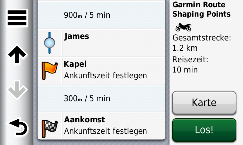
start import of route on Navigator 5 ->success: Route Name is “Garmin Route Shaping Points” ![]()
route is in Belgium, start (green flag), 1 shaping point (blue dot), 1 viapoint (orange flag), destination (chequered flag) ![]()
icons are typical icons for that point types ( I think ‘sym’ and ‘type’ tag are ignored by Navigator 5 )
Names of route points appear (also destination name ‘Aankomst’, not german ![]() ), also info shaping / via point (but I am quite sure: based on content of ‘extension’ tag)
), also info shaping / via point (but I am quite sure: based on content of ‘extension’ tag) ![]()
I also imported the track - works ![]()
name of track is “Berlare_-_Festivalhal,_Berlare”
Forgot to take screenshots, track matches the route path on screenshot above (magenta line). I think content of ‘trkpt’ tags is ignored, only coordinates ( ‘lat’ / ‘lon’ attributes ) used.
Nice ! It seems no negative surprises.
Waypoints: Does the Zumo display both (poi) wpt’s ?
Track: Normal display so 100% compatible as expected, even with the many extra elements attached.
Route: The name tag from gpx base is effectively used in the Via and Shaping Points without negatives by the attached info by type (ignored) so perfect.
It seems no cmt nor desc display as you did not mention the family name of James.
In picture find what is included in the (rte) route. Tnks for the report.
I did not import the waypoints - from my point of view importing the route points as waypoints is useless.
But I can check if someone is interested - but I do not expect problems caused by a ‘type’ tag.
Agree…
So the waypoints I added here are informative free located positions. (No duplicates of the rte)
Sorry I am not sure I understand your comment. What do you mean?
To make it consistent and simply (KISS) uniform with the Garmin mode ( by extension)
Start and Finish indication so by the type Via. (As in the above example picture)
In actual (Beta) indicated by type Start and type destination.