Now that waypoint names and shaping points are available on the website it would be great if there would be an option to export these.
Waypoint names could be used in most export formats.
Shaping points in the export would be very interesting for the GarminShapingPoint export and in the ITN format.
Please let us know if you see other options where this can be handy as well.
I haven’t seen any GPX files recently that use the type for this. Many GPX files use sym to show different types of waypoints on the map. This is usually just visually, but that way it could be used in many GPX systems. As @0709 mentions, the sym is supported in many GPX systems.
Yes and it needs to be done in a way that other systems can understand. I haven’t seen the type tag in many GPX files and I think I have never seen it used for ShapingPoints. That said, it’s definitely good to add it to the type.
But maybe it would be good to also add it as sym so other systems can show a difference for the different points?
As well in the gpx element sym as in type one can add any text.
Sym: (text) Free (usefull)
Use (any) sym from the Garmin Icon range that many gps already understand.
Start: Flag, Green
Finish: Flag, Red
Via Point: Flag, Blue
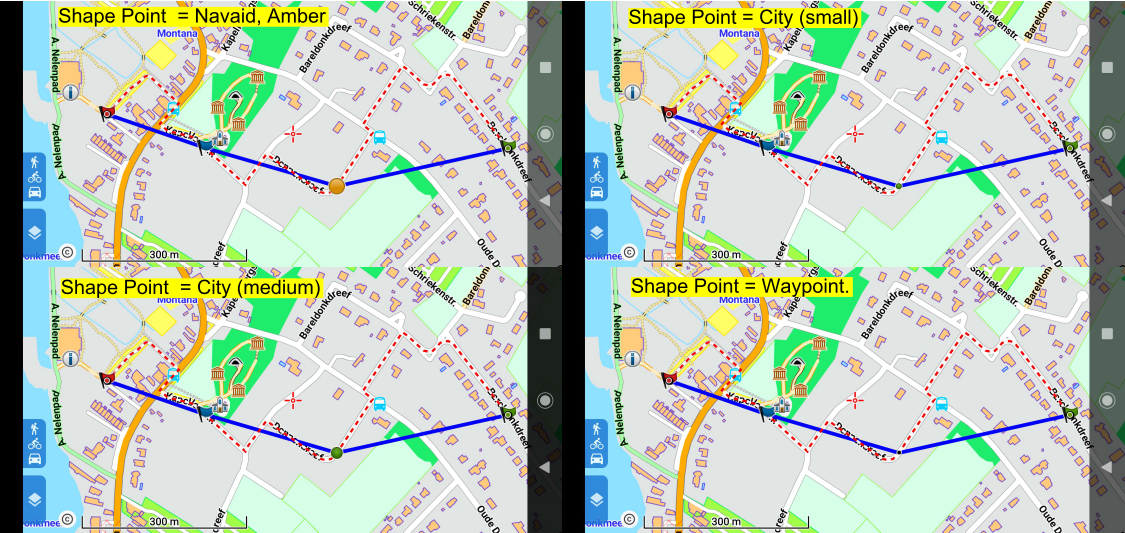
Shape Point: Pin, Green
Type: (text) Free (Info) If attached than prefer “informative” “Via or Shape”.
“Type is hardly used”. Correct.
Sources I found that do add type text in wpt’s. (Purpose unknown)
RWGPS: “dot” (Informative ?)
Bikehike: “The tcx course PointType instructions” (Informative)
Garmin: “user” (Informative ?)
I was playing with some other tools to check if export of waypoint names is possible and can be imported into a Garmin Zumo XT
The ADAC website has a routing feature that is capable of generating a gpx export , the exported gpx file can be imported into the Garmin Zumo XT. the waypoint names will be transferred as Waypoints.
would it help to have an example of this gpx file to analyze?
Sure, please feel free to add sample files - that said, names are well defined for the GPX export, so that feature should be relatively straight forward.
I am currently looking into this issue. It seems that a combination of sym and type could provide the best feature set.
Type seems to be non standardized, so this could be something like:
<type>shaping</type>
<type>via</type>
For Sym I tried to find symbols that have broad coverage across different devices. The Flag and Pin symbols seem to be available on most devices, so it could be like:
Allows Kurviger gpx reimport without losing the Shape Points.
Only by the element type is sufficient for this.
By type specify the points what they represent exactly.
No doubts, clear and straightforward !
Gpx recommends readable text for elements.
I prefer most compact readable text.
So by type Shape.
Shape Point correct English? Check >
See the original.
Website by Dan Foster the gpx developer.
Shape Point is in accordance with:
Garmin as usual calls it slightly different ;-).
Icons are only non-functional “deco” items.
“Tastes and preferences differ”.
(Few) Via Points: Free, use any Icon you like.
(Many) Shape Points: IMO prefer most discreet.
A dot or small circle positioned exactly over the track.
Similar as the Kurviger Shape Point “white dot” presentation.
Thanks a lot for the feedback and for testing this.
Yes exactly. But it would be good to have at least some support for systems that don’t support ShapingPoints.
You are right, probably “Waypoint” would be the best option. That’s what Garmin uses through Basecamp. So I guess unless there is a good reason against it, we should use Waypoint.
We shouldn’t abuse icons like that for ShapingPoints. While they might look correct with the current Garmin device, it might not work on the next Garmin device or maybe on TomTom, etc.
Except by the .kurviger file and Garmin by gpx (with the complex gpx route extensions) I don’t know of any apps that combine Via AND Shape Points so nicely for Navigation (autorerouting) use.
As I promoted this short acronym Shape Points (Dan Foster compact expression) for some time now on many occasions & forums I would personally appreciate its use.
A Kurviger export and reimport by gpx including this non-intrusive simple Shape Point indicator would be quite unique and a premiere by Kurviger.
Shape Icon by sym “Waypoint” indeed seems to me to be the most discreet and so attractive.
as Robin already mentioned the GPX specification contains a symbol tag (<sym>) for route points (<rtept>).
But as far as I can see at least Garmin devices do not care about the symbol ouf route points - newer devices use an orange flag for ViaPoints and a gray-blue circle for ShapingPoints.
Nevertheless the symbol might be a way to store any information for re-import to kurviger or for use in other programs ( e.g. my converter).
Furthermore adding different symbols for this several point types will help on navigation devices which use the symbol tag (<sym>) of route points and display it on the map.
My personal opinion: I would like to be able to see also in navigation device the information, if a route point was a waypoint or a shaping point in kurviger, furthermore I would like to see the name given to a waypoint or a kurviger shaping point.
Therefore I propose to add a hint at the routepoint name for that: For example ‘WP4’ for the 4th waypoint and a ‘FP7’ for the 7th shaping point. So If I have added a 4th Waypoint with the name ‘Lunch’ in kurviger, the name in the GPX would be ‘WP4 Lunch’.
It could be discussed, if the name prefix for shaping points should be ‘FP’ for german variant (Formpunkt).
I just checked: The app uses “Formpunkt” in german version, the website uses “Shaping-Point” in german version - perhaps it would be good to use the same terms in app and website (shall I add a seperate topic for that ?). In that case I would prefer to use “shaping-point” and - of course - the prefix ‘SP7’ in all language versions.
I think the name of the route point can be seen in any navigation device - therefore putting that suffixes to the name works on all navigation devices, so you can see if a point is a waypoint, a shaping point or if it has been added by the GPX export.
This prefixes might be also useful for Garmin-specific GPX export, even, if waypoints are converted to Garmin ViaPoints.
Reason: See if the Garmin ShapingPoints are Kurviger shaping-points (grey marker in app, smaller black marker on website) ore are points added by GPX export. Furthermore when re-importing GPX to kurviger this information also will be useful.
Names are set by users and they expect them to remain unchanged, not modified by applications.
Then also turn instructions and navigation will start to show and speak such strange abbreviations.
The order and type of waypoints are processed and should be rendered by apps (N prefix or icon).
Might be right for some users - but currently the names given to waypoints and kurviger shaping points are completely lost in online GPX export, they are set to ‘WPx’, x = 1, 2, 3, …
No - the prefix should be added only to waypoints and kurviger shaping points - turn instructions do not get a prefix.
 . This helps a lot.