[DE] Ich würde es bevorzugen, wenn die Differenz zum vorherigen und zum nächsten Wegepunkt angegeben würden. Vielleicht wahlweise zum nächsten Punkt generell (shadowpoint oder waypoint) oder nur zwischen Wegepunkten. Weil die shadowpoints bei mir wirklich nur Ziehpunkte sind, um den Routenverlauf festzulegen.
[EN] I would prefer the difference to the previous and the next waypoint to be indicated. Maybe optionally to the next point in general (shadowpoint or waypoint) or only between waypoints. Because the shadowpoints are really only waypoints for me to define the route.
[DE] Entschuldige bitte meine Begriffswahl. “Zwischenziel” = Wegepunkt = via-Punkte. Mein Vorschlag ist also, die shaping points bei der Berechnung und Anzeige (wahlweise) wegzulassen und nur die via-points zu nehmen.
[EN] Please excuse my choice of terms. “Zwischenziel” = waypoint = via-points. My suggestion is to omit the shaping points from the calculation and display (optional) and only take the via-points.
I agree with Georg.
It’s only intresting from one Via Point to the Next.
Shaping Points only for getting the Rout where i Want.
Via-Points are for the next wanted Stop. And then its necessary to know the distance or the Time between them.
Best regards
Gerhard
[DE] Darum geht es aber nicht. Die Routing-Profile zwischen den Punkten werden von der Anzeige nicht beeinflusst. Es geht ja nur darum, dass die Differenz in Entfernung und Dauer zwischen den benachbarten via-Punkten angezeigt werden soll, shaping-Punkte sollen nicht berücksichtigt werden.
[EN] But that is not the point. The routing profiles between the points are not influenced by the display. It is only about displaying the difference in distance and duration between the neighbouring via points, shaping points should not be taken into account.
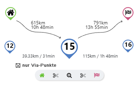
[DE] Es würde schon ein einzelner Schalter reichen: Anzeige mit oder ohne shaping-Punkte.
[EN] A single switch would be enough: Display with or without shaping points.
Um den Vorschlag vom EMUX aufzugreifen, könnte es vielleicht so ausschauen:
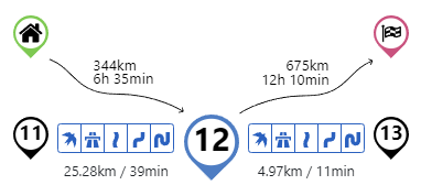
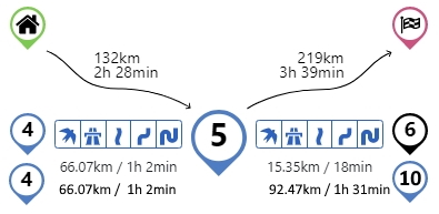
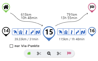
Erste Zeile: Entfernung/Zeit zum vorherigen/nächsten Wegpunkt (egal ob Shaping- oder Via-Point)
Zweite Zeile: Entfernung/Zeit zum vorherigen/nächsten Via-Point
Wobei, wie in diesem Beispiel die Zahlen identisch sein können …
Das Routing Profile kann natürlich nur zwischen den unmittelbaren Wegpunkten geändert werden!
To pick up on EMUX’s suggestion, perhaps it could look like this:
First line: Distance/time to previous/next waypoint (whether shaping or via point).
Second line: Distance/time to previous/next via point.
Where as in this example the numbers can be identical …
The routing profile can of course only be changed between the immediate waypoints!
Honestly I never used this function - I usually plan my route prior I start. In worst case (e. g. bad weather) I would do a replanning on the fastest way to my destination, but I never played around with different routing profiles during a ride. But maybe I am the only one who uses the planning capabilities in such a straight way and other users are keen on the routing profile switch.
Ideally would be IMHO to keep the routing profile switch capability solely between the shaping points and show the distance between each via point.
[DE] Was nützt es mir, wenn ich zwar einen Abschnitt von “kurvige Route” auf “schnelle und kurvige Route” umstellen kann, aber die Eigenschaft “Vermeide Hauptstraßen” und/oder "Vermeide Schnellstraßen " in diesem Abschnitt nicht deaktivieren kann? Aber diese Diskussion wurde bereits an anderer Stelle geführt und ehrlich gesagt, da fällt mir auch keine gute und einfache Lösung ein.
Aber das ist ja hier auch nicht das Thema.
[EN] What good is it if I can change a section from “curvy route” to “fast and curvy route” but I can’t deactivate the “avoid mainroads” and/or “avoid mortorways” feature in this section? But this discussion has already been held elsewhere and, to be honest, I can’t think of a good and simple solution either. But that is not the topic here.
in der Tat, da kann der geneigte User die eigentlich geniale Funktion mit den Voreinstellungen (z. B. vermeide Hauptstraßen aber plane die schnellste Route) komplett blockieren bzw. der Algorithmus hat dann Spaß aus diesen Vorgaben eine Route zu zaubern.
mir ist mittlerweile auch klar, was Du meinst (manchmal brauche ich ein bisschen länger, bin Ü50, da kann das schonmal vorkommen ). Generell nutze ich seit kurzem die Shaping Points nur für den Verlauf der Route und würde auch nur für diese die Routenprofile benötigen. Die Via Points setze ich nur an Stellen, die ich auch anfahren möchte (Tanke, Restaurant, Pausenplatz). Somit sind für mich nur die Entfernungen vom Start bzw. von der aktuellen Position zum jeweiligen Via Point bzw. zum Ziel interessant - das gilt sowohl für die Planung als auch für die Navigation.
Vorschlag: Nur die Shaping Points für die Routenplanung und Routenberechnung verwenden. Die Via Points nur zur Anzeige der Entfernung verwenden, dann hätte man eine klare Trennung. Man müßte das nur deutlich in die Anleitung reinschreiben. Hätte natürlich den Nachteil, daß bereits geplante Routen komplett überarbeitet werden müßten.