Sometimes I want to start the planning with GPS coordinates for a starting point. I’m constantly getting an error message.
I can use coordinates directly if they are not at the beginning.
As a cumbersome workaround I have to set a random starting point, put in the GPS coordinates second, delete the random starting point and define the GPS coordinates as new starting point.
It may well be that I’m missing something and it’s me who is causing the proplem though …
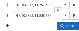
My fault (if one can call it a fault) is that I only did put in the first coordinate and then hit the surch button, expecting kurviger showing me the starting point, from which I would go on.
When I do it that way, I get an error.
With your ‘hint’ I tried to just put in the same coordinate in the first and the second position and then hit the surch button. This works: On the map the start is covered by the end, which I can move by mouse where I need it.
Easy solution - sorry for bothering with such a beginner question.
Yes, that only entering one coordinate isn’t working is a bit unfortunate, I can have a look if this might be improvable. Thanks for letting us know about this.