I mean: Does anyone do not understand the compass, so that it is necessary to show “N” or “NW” below the compass symbol?
Or does it have a special function?
I mean: Does anyone do not understand the compass, so that it is necessary to show “N” or “NW” below the compass symbol?
Or does it have a special function?
Compass is connected to map orientation and rotates to show the true north.
The label shows the compass bearing, i.e. the direction towards location is headed related to north.
It is the same on a real compass
You can deactivate it in settings Einstellungen -> Karte -> Himmelsrichtung 
Manfred
It’s just for convenience. Since some users might not like it, we made this configurable. For example I like it, even though I can read a compass. For me, reading the letter is faster than reading the compass.
Thx for replies!
Okeyy: THIS i did not realize yet, perhaps because my maps are often orientated towards North.
(Is it already explained in documentation?)
Probably not, you can add it if you want. ![]()
Hehe - smart reply … 
Burt confess that still uncertain:
Even in your screenshot compass needle points to the left which means map is orientated and you go East, and letter display is indeed “E” - so no difference between compass andf the letter?!?
It’s just a different visualization of the same information ![]() .
.
The label shows location direction related to compass north.
Can extract it also by compass, text is often easier to understand.
Okeyyy - then it is clear …
(Perhaps I am of a generation which learned to navigate exclusively by compass - in our camping car we still have a good analogue boat compass besides the smarty with Kurviger - sometimes it helps, and you see which direction sun will rise in the morning after stealth camping …  )
)
BTW: Can you on occasion correct German version to “Zeige Kompass-Himmelsrichtung” (with “-”)?
Sure! ![]()
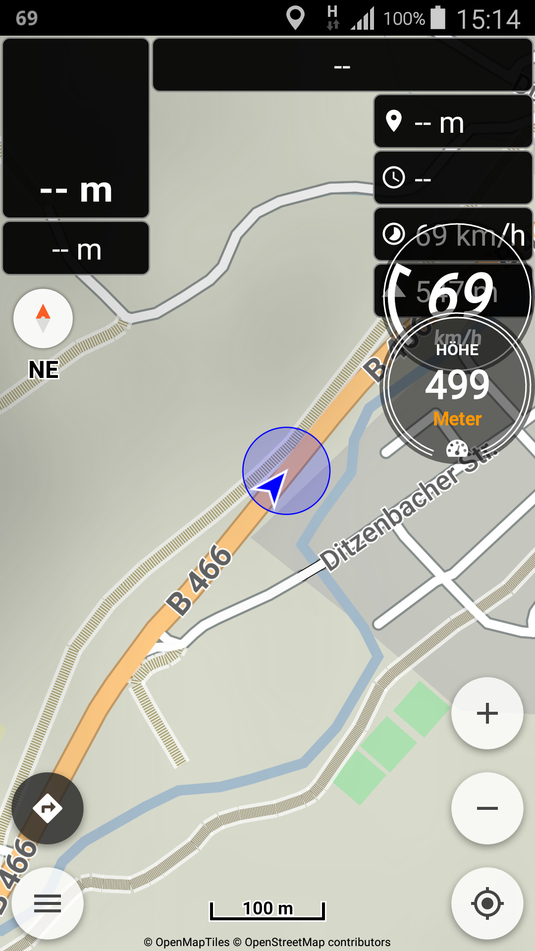
Had another look yesterday:
Posts sounded a bit contradictory. So let us better get this all more precisely (and how it should be described in Kurviger’s documentation):
a) if map is orientated following current moving direction (GPS or Compass), you are right:
In this case compass and label information ARE equal,
what means, you may decide, wether you choose compass or label for orientation.
BUT
b) if map is orientated to north (Manual), they are NOT equal:
Compass shows indeed to north, but label shows direction of current movement (like in screenshot).
(BTW: Screenshot shows overlay display of Ulysse Tachometer, how I use it for larger display of speed and altitude, and also shows another case of disappeared header information after leavibng the route - something which still causes problems to me, but is not the topic here.)
The (a) is demonstrated in my post above, where map orientation comes from location GPS.
It doesn’t seem any equality, compass points to the North and label shows location direction.
Regarding navigation panels, when being off route they don’t show any info, until resume.
Yes, but in your ascreenshot rotation of compass (east towards top of the map/screen) reflects exactly the movement direction (east towards top of the map/screen), so no additional information.
Let’s see it in users view (and describe it like that in documetation):
User has to know, that in the case of map’s orientation to north, the label gives the additional direction of current movement and is therefore useful - or?
(OT: Header information was missing despite I had acticated recalculate route and mobile net was shown with a “H”, and no warning about missing mobile net, so I suggested there WAS an interbnet connection. But let us discuss this once again in another topic, if useful.)
In my screenshot the compass points to the left where is map’s north.
Since location arrow points forward, can derive the location direction to East.
Similarly to your screenshot, each shows different information.
Compass symbol the map north and label the location direction.
See, wether you agree with this following description, so it could be added to documentation:
The arrow of the compass symbol shows, as every compass, the direction to the geografical north.
The label (letters of compass directions) below shows the direction of current movement.
If the map is orientated to follow moving (option Map - GPS), both show of course the same information.
![]()
With Map orientation | GPS the map rotates with movement direction, so that location arrow is always upwards. e.g. in 1st image, map & compass north is left and the direction label shows East.
Doesn’t seem any “same information” in any case.
