[EN] I think I have found an issue with the route calculated by Kurviger
[DE] Ich glaube ich habe einen Fehler bei der Routenberechnung von Kurviger gefunden
[EN] Here is a url to a short example (<10km) that shows the issue:
[DE] H
ier ist ein Link zu einer kurzen Route (<10km) die das Problem zeigt:
[EN] Description of the issue and how it should work instead:
[DE] Beschreibung des Problems und wie es anstatt dessen funktionieren sollte:
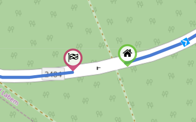
Ich habe heute eine Route durch Tschechien planen wollen. Bei einer der Straßen stimmt was nicht. Kurviger plant aufgrund fehlerhafter Daten bei Open Street Maps einfach drumherum. Kann sich das mal bitte jemand mit Ahnung anschauen? Bei OSM wir auch ein Fehler angezeigt.
On a road like that it’s incredibly likely that we can drive through this gate. But just to make sure: do you know this region/road and know it’s allowed to go through there?
I don’t know this road. I just planed a route and was wondering why it dosen’t go through this street.
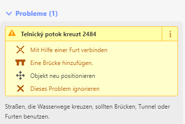
I may have to check it on side. I`ve been confused by this massage in OSM:
But it seems not to be the problem of the Routing issue.
No, those are just warnings, as linux-user and me said, the reason is the gate. I am usually very uncomfortable editing this without local knowledge but… this case seems super clear cut. This is even an access route to the ski lift up there, it’s probably just used to close the street when snow is too high, so I’ll edit it real quick
The only correct attitude for any OSM edits. Although in this case it seems correct. Google streeet view check shows a (summer) open gate here. Road 2484 without winter maintenance according to:
It shows again how much it is needed that Kurviger routing on such a detail does not get stuck and still allows a passing. At real navigation than warned by a overlay section “xxxxxxxx” design.
Profile: Manual. Bridging by a straight line between shaping or Via waypoints.
Profile: Shortest OSM. Use an already plotted OSM traject path without restriction between shaping or via waypoints.
This way there is no reason for OSM to be possibly messed up by fast uncontrolled distance edits.
Tnks Emux. Probably it is very similar.
This profile Shortest OSM (expression to give it a name) is used in Route You. The advantage above straight is that it does follow an OSM path inclusive the curvatures. I recently so noticed one motorbike design where because of road maintenance and new constructions very temporarily a very nice (NL) cycle path so could be used and planned. Imo it does not make sense tot add all such road constructions into many OSM edits. Not in my (BE) country at least for sure. Construction planning is a month to go for example but in my country you never know in what year the job will be finished. Well we locals are used to that, so must be flexible and inventive usually.