Indeed  but I am looking to plan my summer !

Actually there was no issue on OSM, but only on Kurviger is does the loooonng path - still today
@arnauddominique.lina
It takes 2-3 days until kurviger has the new details from OSM. Just take a look on Wednesday again.
2 Likes
Assuming you are talking about the part between (17) and (18) …
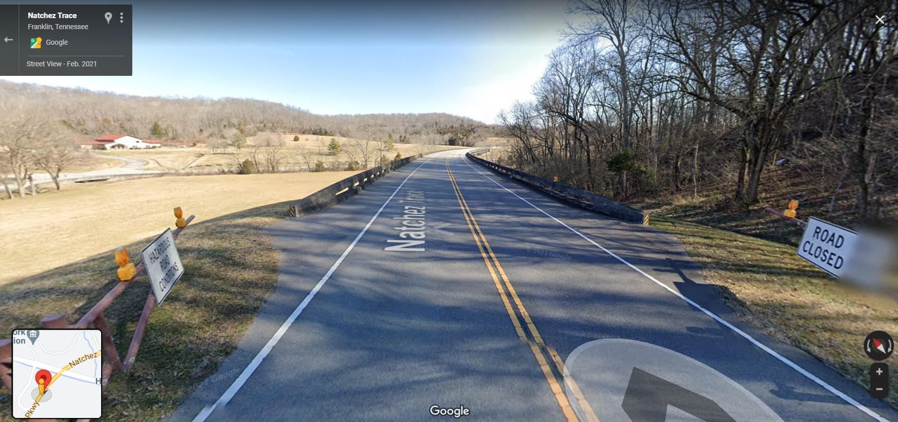
There is a gate which may be closed under some conditions (snow ?):
Again “Access=Yes” could solve the problem - or (if you are Tourer-Subscriber) use the beeline:

1 Like
Gate is closed only for snow, doesn’t happen often in Mississipi. Hiw do I set Access=Yes and how do I beeline?
Using the picture from @zaphod_42: Beeline = route profile “Straight line” between waypoints 17 and 18: To select this route profile between WP17 and WP18 (marked with circles) you have to click the bird icon (marked with a circle). This route profile is only available for you when you have Tourer subscription.

1 Like
Have tourer subscription. Planning route on desktop computer. Don’t see a bird icon. Where is it? Can’t seem to find info in documentation
Ok. See what you meant by bird icon. How do I
Make a beeline?
David,
it’s quite easy: just click on the bird icon between the waypoints (17) and (18) and the beeline is created - see icon at the map:
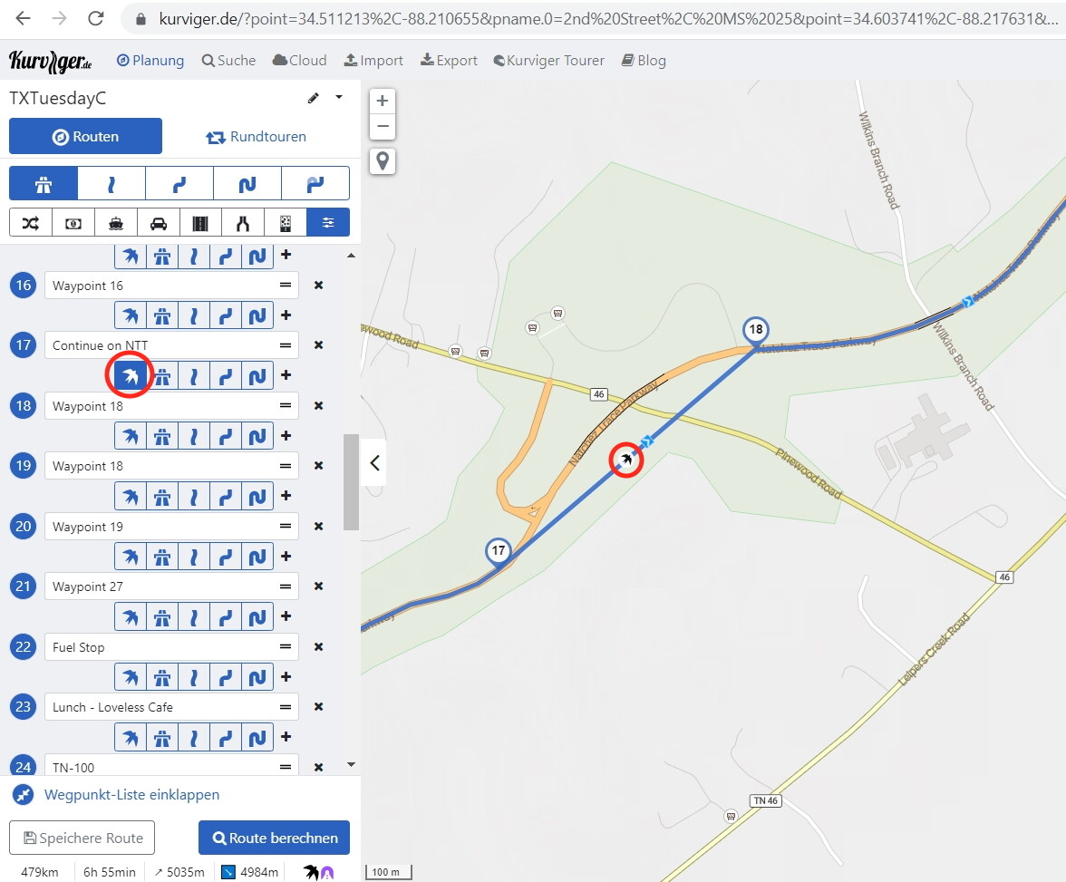
Btw: your waypoint names are a little bit strange …
1 Like
The beeline trick is fantastic ! Thank you !
Quick reminder to the community that we must always represent reality on OSM please, and not set access according to our wishes ![]()
In this specific case, for snow closures, the OSM wiki recommends the following:
Add access=yes and access:conditional if the access level changes under circumstances like snow, ice, or flooding.
[Emphasis mine]
If you know that a gate is closed at a specific date (for example always from october to march) you can add that in the condition like so:
access:conditional=no @ Oct-Mar
See more info here
2 Likes
Route still does not work due to 2nd barrier ![]()
I set access=yes also there…
1 Like
Ahh! This “solves” the problem in my routing. But it can’t be the solution to this type of problem. The OSM access needs to be set to the default value. In this case, the gate is normally open and onlyclosed for snow, flooding, repair etc. Access should be set to yes as the default value.
On the plus side I learnt how to detetmine why this ocurrs and ti bypass it.
Thanks a lot to everybody here. I did not anticipate that much information and learning with my post !
Ok… now I have another problem. When I re-import the route, the beelines do not load. How do I save the beelines so they are included in the gpx file?
GPX is intended for transfer to 3rd party devices/SW. For transfer inside Kurviger you should use the native format (.kurviger). Please see
Transfer a Route within Kurviger or Save it for Later Use [Kurviger Knowledgebase]
5 Likes
Understood. But I export GPX to my Garmin GPS.so the questions remains on how to keep the beeline in a GPX format.
The Garmin does not care about the beeline. It has to calculate a new routing, usually based on the route you export.
The interesting question is, if the Garmin can plan the route segment between the two beeline points …
2 Likes