@Pete I can help you with filtering the waypoints - here is an Excel macro kurviger.bas.zip (620 Bytes) which does exactly that. The macro is called “kurviger” and can be called with CTRL-k. You have to extract it to kurviger.bas and import it bei ALT-F11 in Excel.
It first kicks out the annoying turn graphics, puts everything into a single-line format, and determines the number of records. Then it hides all the lines that don’t contain a waypoint. The latter I recognize by the fact that there is no “single distance”. Unfortunately, the waypoint names are not transferred to the roadbook today. The further formatting in kilometers and HH:MM I leave to you - there everyone has probably his preferences.
@zaphod_42 brilliant, works like a charm, thanks! That actually makes it a bit easier, although you still have to repeat the copy/paste export + makro execution after each update to the route.
But also shows that I’m not the only one looking for a “waypoint only” overview.
No @pete, I’d not vote for this feature. It was just jogging for my brain to develope an excel macro yesterday evening, instead of watching tv or reading a book. The first macro I wrote since more as a decade …
In my opinion, it is difficult to automate the selection of day tours. Too many parameters influence the number of kilometers:
the route (highway, country roads, passes, gravel),
the POIs (visit a castle),
the breaks (French like to eat longer than 2 hours),
hotel search or already booked?
etc.
I also try to plan the overnight stay in an interesting place.
And I couldn’t agree more! Choosing a spot to stay for the night depends on many many factors, so it’s part of the planning game to balance these out.
I spend some more thoughts on how this could be supported a little more - even though I could work around it with your guys advice and help (thanks for that again). So, please take this just as a brainstorming idea:
To visually support that its time to plan a overnight waypoint whithout having to introduce another button, the route itself could have a short marker for every 25km and a bigger one for every 50km from the last waypoint (or something similar).
So the userstory would be: I change the non-overnight waypoint to shaping-points and then count the preferred number of markers (depending on my appetite for distance, POIs, breakfast etc and there I look around for a hotel/campsite.
I added a (poorly made!!) scribble to make it a little clearer.
With 25-/50-km indicators, I think we overload the route. Perhaps a 100-km index would be a compromise.
But anyway: I don’t need to count along this “string of pearls”, because it’s already possible to determine the distances - with the topography diagram. Example:
Since at exactly 300km no hotel will be found, we simply take the next larger town and start the search there. Once the hotel booking is made, I set an intermediate destination at the hotel address and split the route there. After three splits I have my 4 day tours.
Who wants to try it “live”: Kurviger
I want to continue or restart or vote to this topic of pete.
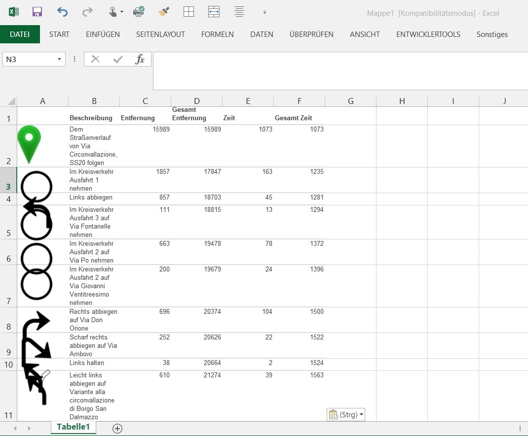
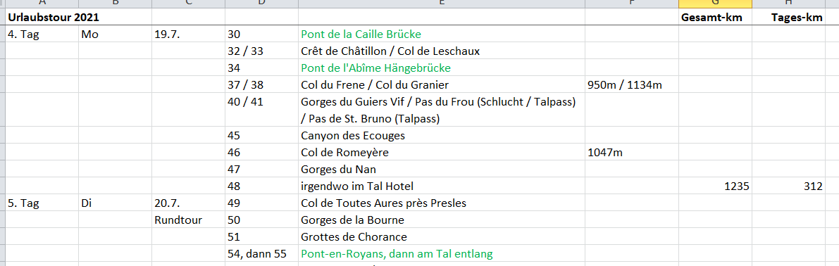
Actually I’m writing my own roadboak in excel with the planned date, number of waypoint, name of waypoint, , in case of passes also the height, daily km, complete km of the route.
For the ca-planned hotel I’m using a personally named waypoint where I want to stay overnight (ca +/-km). Since the naming of waypoint is possible I don’t need any separate waypoint-function for “hotel” anymore.
But a shortened roadbook to excel or whatever would be faster and easier
My problem with the roadbook is that on tour I want to “cut” the route day by day, the splitting function is very usable. So all “used” waypoint of driven route could be eliminated.
BUT in case of new starting or splitting a route all numbers of waypoints are numbered, starting with 1. So my excel-roadbook for the complete route is not correct anymore and it’s not easy not to loose the overview what was planned. Is there any possibiltiy to do it another way?
In former times the planned route was shown in the app (in blue), and everything what was driven was removed (and only documented by the red track). So it was easily possible to orientate what was “old” and what’s coming new. In this case it would be possible to use the full route day by day. Is there any way to do it similar today?
(is this a plannung function of website or routing funcition of the APP?)
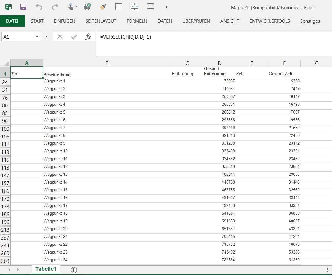
here is a macro that shrinks the notebook to “waypoints only”: Roadbook_shrink.zip (415 Bytes)
If the selection “waypoints only” would be offered when creating the roadbook, this intermediate step could be saved.
Of course, the names of the waypoints would be of great advantage …
It could also be a possibility to insert a waypoint and then include a function that asks for the distance to WP? or Start, or for the time.
This new WP would then be automatically moved on the route according to the information distance/time and there you could then search for a hotel nearby.
Ich schreibe mal in deutsch, um Missverständnisse zu vermeiden.
Mir geht es auch so, dass ich gerne nach der Zeit oder nach KM einen WP setzen möchte, um dort zu essen oder zu übernachten.
Also wäre es doch sehr einfach wenn es eine Funktion geben würde, Wegpunkte nach Zeit oder Entfernung zu verschieben.
Ich setze einen WP, rechte Maustaste und das aktuelle Fenster erscheint, hier eine weitere Funktion einbauen wo man sagen kann:
Verschiebe WP in Abhängigkeit zu (freie Eingabe) WPXX oder Start/Ende in KM oder Zeit.
Es wäre so sehr komfortabel.
Allerdings kann man aktuell auch einfach den WP anklicken und links erscheint dann die Entfernung und Zeit zum Start und kann dann den WP manuell verschieben.
@ Hobbyfahrer:
das wäre nicht mal mein Anspruch. Ich setze den WP gerne selber, kann ja nachschauen wieviele km man ungefähr hat - und ich habe eine Varianz üblicherweise von locker +/-40km je nachdem was ansteht, da hilft auch keine Sollvorgabe mehr. Wäre also nicht mein persönlicher Favorit
Better, but not completely perfect
It would be nice to export the list with waypoint name and these informations who are in the background.
Here we have the distance from start and distance to end
→ distance to the next point and previous point would be more informativ.
The same with time.
For me it’s not useful to know that the trips will need 4 days, if I’ve planned a 14day-tour. It would be interesting to know time and distance point to point. If then this could be exported, additionally everybody can add then more informations / columns for whatever, e.g. the planning "first day, 2nd day, 3rd day etc…
Also I don’t know if roadbook is then the correct name, it’s more the export of the list?
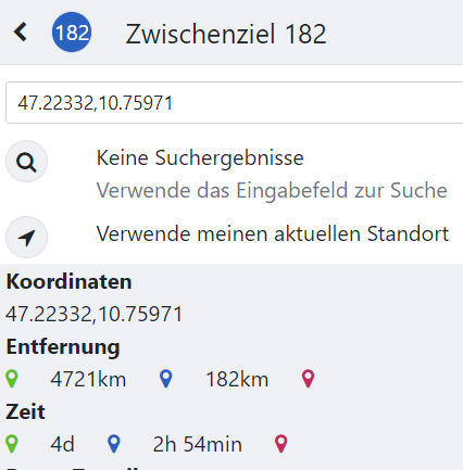
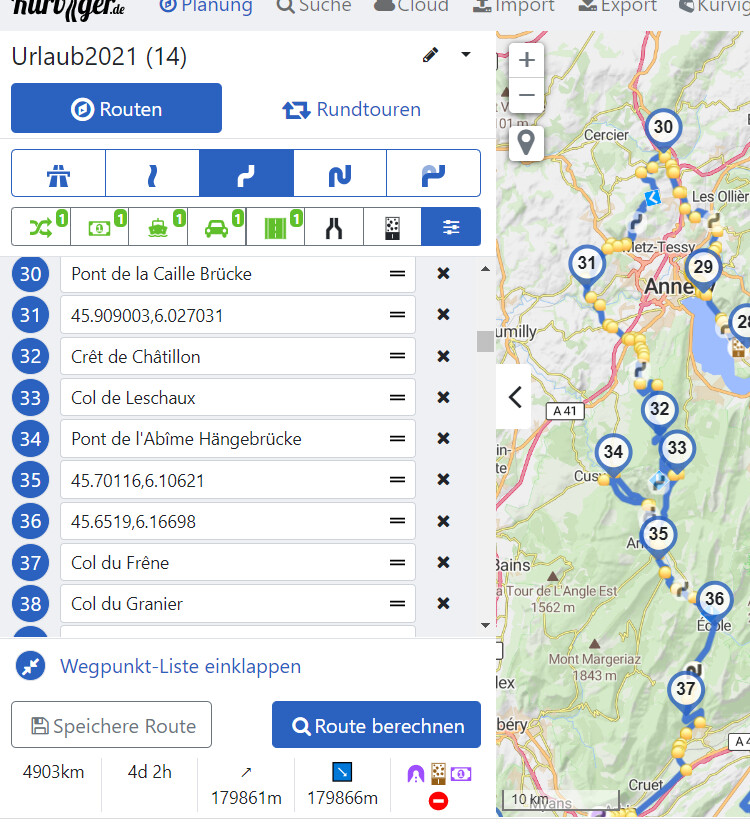
see here my example:
hotel is at point 29 (Annecy) and 48 (somewhere Vercors -west)
(not shaping points, though now they show that info)
Garmin BaseCamp: Shaping points are any position along a route that will not alert you when you arrive. Shaping points do not contain arrival time or distance between points information.
Genau, alternativ kann man auch über das Höhendiagramm mit der Maus fahren und sieht die Distanz. Ich versuche bei Dingen die man auch gut so erledigen kann einen extra Button zu vermeiden, dadurch wird die Bedienung am Ende nur komplizierter
In your case, that is correct, if you plan a multi day trip, start and destination is less meaningful than next / previous waypoint. One thing on my todo list is to improve the distance and time display for waypoints (for example showing distances and times to all other waypoints).
Yes, I am not sure how something like this would be called
Red track mentioned above = The recorded driven track right ?
The (app) behaviour as before was indeed a bit more informative.
Possibilities:
Either the already consumed navigation track part “fades out”.
Or the already consumed navigation track part “disappears completely”. In the latter case, than optimally choose @ import route file Overlay + Routing (Encourage by show as first choice in the list)
(Worth a new suggestion but than in the app category of course ?)
I do know Emux, which app you mean more specifically here
In Kurviger app, after recalculation, the previous navigation track visually disappears, doesn’t it ?
(Well not recently checked again it is also not necessary I think to dissect this deeper)
You know exactly what is meant, I trust you to decide what makes sense or is technically possible or not.
Regards.
I must say that I also like this very much. And it is already simply present now. You just have to remember to select that “optimal” third choice from the list at import.
The thread made me think about my first tryout of the app. The thing that surprised me the most then was UI. It was very hard to get through it because it seemed to be more of a software for engineers. So, the first time I used it was when I tried to reach any hotel near me open at that time because it was late at night. Luckily, I managed to get to the hotel, but I realized that I should probably plan the route via Kurviger in advance. I’ve been using the app for years, and now I have no idea how I can plan the route without it now. The thing I love the most about it is the new system of planning the route, which helps you to avoid highways in separate areas. Btw, importing different POIs is also cool.