Hi. Is there a possibilty to create an automatic offroad trip? No street use or some kind if mixture offroad and street.
Regards Marcus
Oft sind’s ja nur kurze Strecken, die man abseits der Straße (unerlaubt!) fahren will. Dann kann man sich helfen: den Track entsprechend modifizieren und bei der Navigation nach “Route verpasst” einfach dem Track folgen bis die Route wieder erreicht wird.
Beispiel:
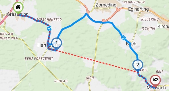
Kurviger, zwischen (1) und (2) soll querfeldein gefahren werden.
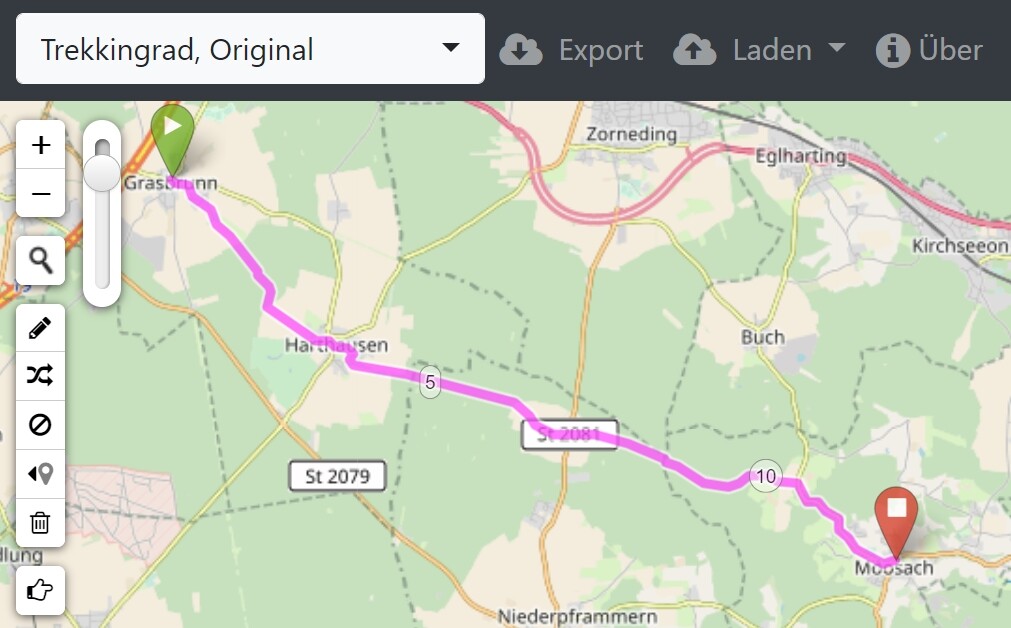
- Export als .gpx (Track und Route)
- zwischen den Wegpunkten 1 und 2 alle Track-Positionen löschen
- dann erhält man Grasbrunn - Moosach_straight.gpx (19.6 KB)
- Perfektionisten können Track-Positionen entlang der Waldwege einfügen, siehe Grasbrunn - Moosach_detailed.gpx (26.9 KB)
Ich benutze für diese “Operationen” den RouteConverter, aber es gibt natürlich andere Tools en masse.
Natürlich stimmen bei dieser Vorgehensweise die Entfernungen und Zeiten nicht mehr, aber das kann ich verschmerzen.
Often it is only a short distance that you want to drive offroad (without permission!). Then you can help yourself: modify the track accordingly and when navigating after “route missed” just follow the track until the route is reached again.
Example:
Kurviger, between (1) and (2) there should be cross-country driving.
- export as .gpx (track and route)
- delete all track positions between waypoints 1 and 2
- then you get Grasbrunn - Moosach_straight.gpx (19.6 KB)
- perfectionists can insert track positions along forest paths, see Grasbrunn - Moosach_detailed.gpx (26.9 KB)
I use the RouteConverter for these “operations”, but there are of course other tools en masse.
Sure, with this approach the distances and times are no longer correct, but I can live with that.
1 Like
Automatic & Offroad. It is clearly contradictory.
Without osm road or path available, the motor router cannot present one.
Probably meant are paths that ‘citizen’ would rather avoid by road motor bike.
Something quite different from what the standard current Kurviger router presents.
No such profile is provided for the slightly rougher versions of motorbikers.
The app can navigate it when importing even such a “rougher” design.
Attached a short CYCLE BIKE route on which I often test navapps.
App with Brouter and suitable profile or GraphHopper design, but GH disappears.
And the B-router keeps uncomfortably “bleating” too long to return if you deviate.
Kurviger app in se was doing well, but it was no more than a short test.
Makes no sense without comfortable (bicycle) route design support.
This is far out of the comfort zone provided by the Kurviger (motor)router.
Import in app ! Testcircuit 0709 brouter_zossebart_MTB_profile.kurviger (2.8 KB)
1 Like
Im Prinzip sollte es einfacher gehen. In Kurviger BRouter Offline auswählen und im BRouter Trekking oder Enduro als Profil wählen…
In principle it should be easier. Select Offline in Curvy BRouter and select Trekking or Enduro as the profile in BRouter…
Heiko, mir ist schon klar, dass BRouter das kann:
Aber dann muss ich in den Flugmodus gehen und offline navigieren, was zur Folge hat, dass die gesamte Tour BRouter-mäßig umgerechnet wird. Ich will aber nur kleine Abschnitte innerhalb einer Kurviger-Route “anders” fahren.
Bei den geplanten unterschiedlichen Profilen in einer Route fällt hoffentlich auch eine gerade Linie zwischen zwei Wegpunkten ab. Das würde es wirklich vereinfachen.
Heiko, I know that BRouter can do that:
But then I have to go into flight mode and navigate offline, which means that the entire tour is converted BRouter-wise. But I only want to navigate small sections within a Kurviger route “differently”.
With the planned different profiles in a route hopefully a straight line between two waypoints will also drop off. That would really simplify it.
1 Like
If there is interest I could examine the possibility to use different routing services in the same route.
i.e. some parts of route calculated with Kurviger and some parts of route calculated with BRouter
Let’s discuss that in its topic:
2 Likes