In my opinion it would really be a great improvement to be able to change the names of the waypoints in my route. It’s OK to have all those “via point xx” by default, but certain waypoint on a route often have a special significance. For example because there’s a restaurant with a planned stop, a parking lot to meet other buddies or a certain location to be visited.
It’s sometimes quite confusing to have a good overview over your route without the possibily to have custom names for your waypoints.
And of course it should be possible to keep the names of an imported GPX-file. Quite often imported routes are planned with another tool (like Garmin Basecamp or the MyRoute-app platform), and some waypoints have significant names to be better recognized while being on tour.
I would even go one step further and provide the option to choose special colours for waypoints. So it would be much, much easier to identify special waypoints on your route when switching from navigation mode view to normal map view while being on the road. Simple thing, great effect.
As a minor addition to this feature, we could also think about showing the names of the waypoint on the map, next to the waypoint without requiring to open the waypoint bubble.
Hallo,
ich hätte da mal eine Idee.
Wenn ich eine Route plane (App) habe ich die Option “setze als Zwischenziel” (ist ein Wegpunkt).
Könnte man vielleicht eine zusätzliche Option einbauen “setze als POI” mit der Option ihn umzubenennen und das man die gesetzten POIs z.B. als eine “rote Fahne” während der Navigation auf der Karte sieht.
In der Wegpunktliste sollten dann die gesetzten POIs auch als POI angezeigt werden.
So hätte man denke ich auch eine bessere Übersicht zwischen Wegpunkte und POIs.
Ist halt mal so ein Gedanke
Gruß Oliver
Steht dieser Punkt, Benamung der Wegepunkte und beim Exportieren die Übernahme der Namen in die gpx-Datei, auf eurer ToDo-Liste?
Leider gibt es in der Web-Ansicht keine Favoriten wie in der Smartphone-App. Schade, dass ihr dies (noch) nicht kompatibel gemacht habt.
Is this point, naming the waypoints and exporting the names to the gpx file, on your ToDo list?
Unfortunately there are no favorites in the web view like in the smartphone app. Too bad you did not make this compatible (yet).
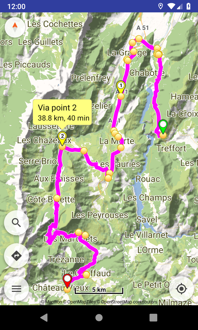
Es gibt in der App ja den Punkt Wegpunkte unter Routing, könnte man dort nicht noch anzeigen wie weit es bis zu diesem Wegpunkt ist und wann er voraussichtlich erreicht wird. Die Punkte die schon erreicht wurden brauchen ja dann nicht mehr angezeigt werden. Wenn ich dann dem Wegpunkt noch einen Namen vergeben könnte, wäre es perfekt für mich.
Gruß Jürgen
Das was ich meine ist nicht die Zeit bis ich den Wegpunkt erreiche, also im Beispiel 40min., sondern zu welcher Uhrzeit ich dort ankomme. Wenn aktuell 13:00 Uhr ist, plus 40min, dann komme ich um 13:40 Uhr an. Wenn diese Uhrzeit noch dabei stehen würde, fände ich es perfekt.
Gruß Jürgen
Note that Routing is a static process (calculated once), while Navigation is a dynamic process (calculated continuously).
Waypoints on map come from simple routing. To show in their info bubbles the estimated time of arrival, would work if user enters the time of departure and update once.
That’s a job for navigation panels and the feature to display distance / time to a certain waypoint:
Also ich fände ein solche Möglichkeit auch ganz toll. Hier wäre eine Listenfunktion ganz toll, die in Tabellenform aufgeführt ist. Zum Beispiel so:
Punkt 1 - Name des Routenpunkt - Entfernung in km - Ankunftszeit Uhrzeit
Punkt 2 - Name des Routenpunkt - Entfernung in km - Ankunftszeit Uhrzeit
Punkt …
Wenn der Routenpunkt 1 erreicht wurde, dann braucht dieser natürlich nicht mehr angezeigt werden. Anhand eines eindeutigen Namen für den Routenpunkt, kann man so super schnell sehen, wann ich z.B. die Fähre am Punkt 10 erreiche.
Gruß Jürgen
For the web app I think it is very important to be able to do one of the following while planning a route:
Set the name of a waypoint
Add a note to a waypoint
Set the color of a waypoint
Any one of these options would allow me to mark significant waypoints that require me to take an action during the trip. For example a gas stop, a scenic spot, a meetup, etc.
You side this is in your todo list but it has been 1.5 years since the request so what is the priority?
Hi ninloot,
from the hints that have been dropped here and there I would say that this feature is high on the list, but please keep in mind that this app has a veeery small team and everybody’s already doing their best all features come out when they’re done and there are no fixed promises for dates
I hope you can still be happy with the app for now. I personally recommend having a Google maps MyMap or similar list of Hotspots ready for any tour, additionally
I think an implemenation of waypoint names / colors / categories is somehow difficult due to the format Kurviger website and app use for exchanging and saving routes.
Every waypoint is only stored with its coordinates. By adding huge additional information (like names, colors or categories) the format wil get quite “bulky” an there are some difficulties and risks (e.g. if using special characters in names etc.).
So maybe a simpler approach could be a good compromise: using only one additional character (A-Z) per waypoint to classify it. Then the format would stay compact as every waypoint would be stored like “point=48.366804%2C10.898697%A” for example.
By using A-Z he amount of possible labels should be enough for a quite flexible usage.
The user should then be able to select the classification label A-Z for a waypoint (A could be default) and to configure his own name/category and color for every label on the website and in the app.
In the app the simple label character (A-Z) could be displayed additionally to the number of a waypoint in the according fields and display elements (better than longer names) and be displayed in the configured color. Therefore displayed information would stay neat and clean although different types of waypoints can easily be distinguished.
If exporting a route as GPX the configured name/category of a waypoint could be used in the <name>-tag, so that this individual information would even be preserved if sharing the route.
Absolutely. But I think the URL format is used (and necessary) for handling routes on the Kurviger website, right? Or would there be also a possibility to use JSON?
In theory we could encode the whole content of the .kurviger json file in the url. There are existing standards to encode information in urls for example here or here.
Unfortunately, browsers do limit us here quite a bit with the url length. Different browsers support different url lengths. Generally it’s recommended to stay below 2.000 characters. Current browsers support over 30.000 characters. Which might sound like a lot, but the .kurviger for a medium sized route would probably not fit. Longer routes will definitely not fit.
Transfering only waypoints and some routing parameters should fit however.
That’s the point which I thought could make trouble.
That’s the point which may be solved by using a pragmatic format with a small footprint like in my suggestion. I think you always have to accept trade offs concerning certain aspects. But it would nevertheless improve flexibility.