[EN] I think I have found an issue with the route calculated by Kurviger
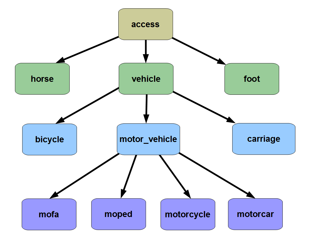
Kurviger routes over roads which are tagged as motor_vehicle=private in OSM, i.e. you need the owners permission to traverse them.
[EN] I read the corresponding documentation
[EN] Here is a url to a short example (<10km) that shows the issue:
[EN] Description of the issue and how it should work instead:
Kurviger has no way knowing if any particular user has the owners permission utilize a private road or not. If it would refuse to route over such roads by default, things could get really frustrating e.g. if you live along such a road or are indeed the owner.
May I suggest an added option in Kurviger, consider private roads, which default to true for backwards compatibility?
Probably it’s similar with the latter? Only Robin (the inventor) can speak to the algorithm itself, but I kind of agree with you that “private” is private and shouldn’t be routed at all
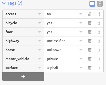
P. S. There’s also access=private? What’s the difference?
It’s similar, but not quite the same. The previous case had other issues in OSM, whereas in my example, it’s just motor_vehicle=private.
I don’t know what access=private is, but my guess is, it applies equally to pedestrians, bicycles, motor_vehicle, and horses. If that is correct, then it would not be applicable to my example.
access=destination means that you are allowed to use the road if you have business there, like living there, visiting someone, go to a store there, etc.
access=private is an actually private road. Usually these are driveways to houses, factories, etc. You are only allowed on this road with permission of the owner.
@Snarkdragon, the road was changed 11 hours ago. Currently, data changes need up to 3 days until they show up on Kurviger.
The latest tagging looks a bit weird to me. I don’t know the local rules, but to me it seems like the easiest would be to either use motor_vehicle=private or motor_vehicle=destination. Having tags like access=no but foot=yes can be difficult for some routing software to properly interpret, some will block foot access, others will allow it, if these situations can be avoided, that would make it easier .
Regarding the tag horse=uknown, I don’t know the local rules, but usually if there is no sign, it is either permitted or forbidden depending on the local rules? If you can’t verify the information locally, then it should not be added to OSM . If you are interested to why, see the OSM Wiki here .
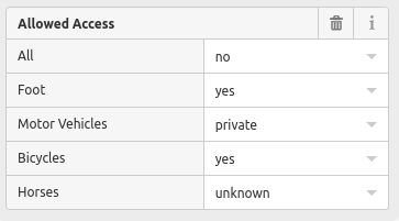
So, there’s a possible contradiction between all=no and bicycle yes. Unfortunately, I don’t know how to remove the all tag. Would all=yes be a safe choice given the value for motor_vehicle?
motor_vehicle=private I am sure of, there’s a sign saying exactly that.
As for horse=uknown, IANL, so I really don’t know. I could change it back to yes, as it was before.
The up to three days thing is a surprise - my first edit in OSM was changing a ferry incorrectly tagged as taking motor vehicles. That kicked in within seconds, maybe i just got lucky the first time?
Can use the “Show on OpenStreetMap.org” option and check the OpenStreetMap data in their website.
(available in “More…” options when long press on map)