My first feedback: thank you for another update with great improvements! ![]()
![]()
Weather’s getting better now, so I hope to be able to test them on the road soon. ![]()
My first feedback: thank you for another update with great improvements! ![]()
![]()
Weather’s getting better now, so I hope to be able to test them on the road soon. ![]()
Wow - GREAT improvement!!!
THX A LOT!!:![]()
A short feedback: this doesn’t work if I am (or was previously) in the “follow position” mode of the map view. Maybe this mode could automatically be deactivated to be able to see the selected waypoint from the bookmark or waypoint list?
Deactivate automatically a mode would be a bit forced behavior to user. ![]()
I can examine to implement also there the 10" auto center (zoom) that navigation has now if user scrolls (zooms) the map.
So selection will scroll / zoom and soon after the auto center / zoom will work again if navigation or follow location are active.
Thank you very much for this new tool!
One question: Is there a gpx-file or another format, where the route ist stored after stopping navigation?
Where can I find it?
Michael
Nice question! ![]()
The track with all details is recorded internally in a DB for optimal performance.
It stays there immutable from app restarts - until explicitly “Clear GPS logging”.
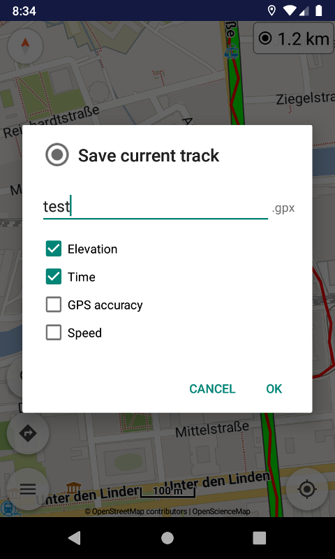
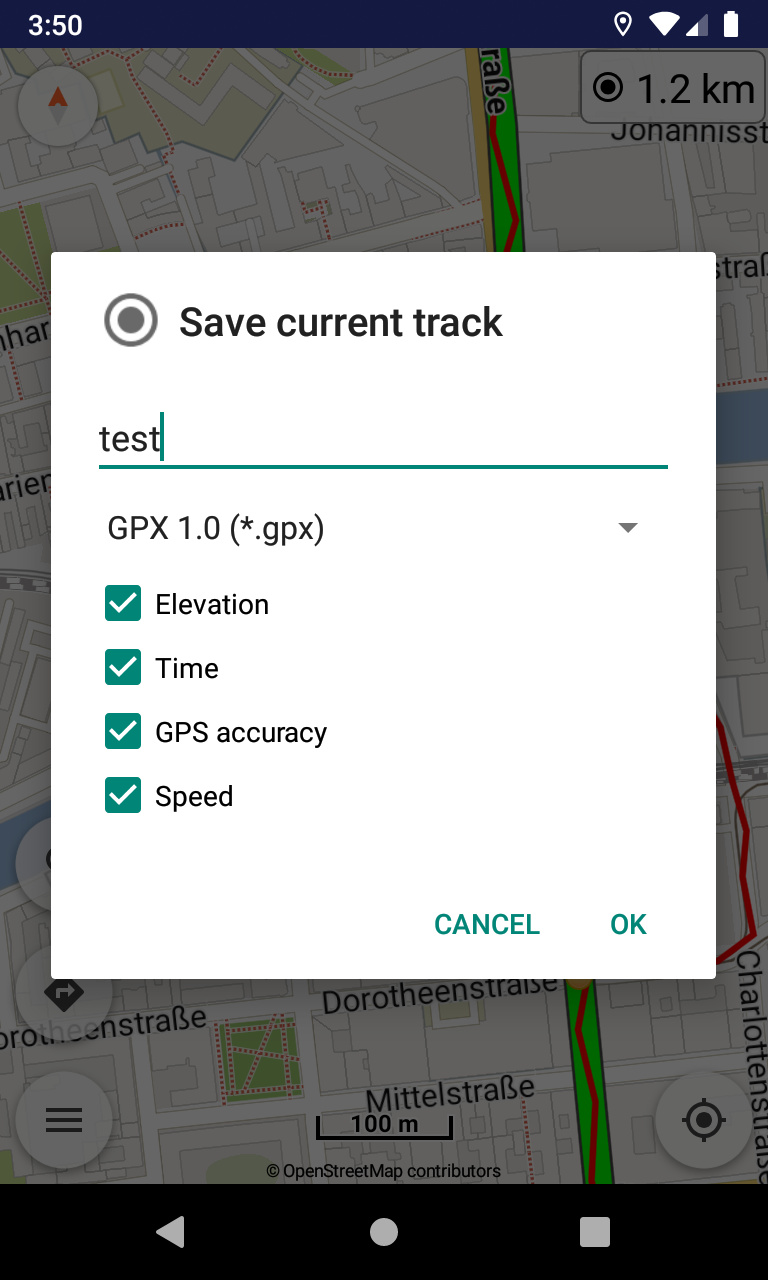
Anytime can save the current track, selecting also the data to enter in GPS file.
Great feature, actually!
Where do I reach this menue point?
Can enable the tracking widget (top right) via “Tools | GPS logging” menu.
If mean its save dialog, can tap widget to record a track & see all options.
Thank you., got it.
I find these nice gpx-files in the root of the main-storage. Is there a possibility to adress the storage at least in the default kurviger location, or even better, can I define a default storage folder on the phone myself?
Can specify the export folder in “Settings | Application | Export folder” for all save / export actions.
I tested GPS logging on my way back home from the office.
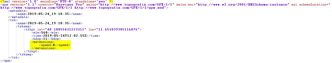
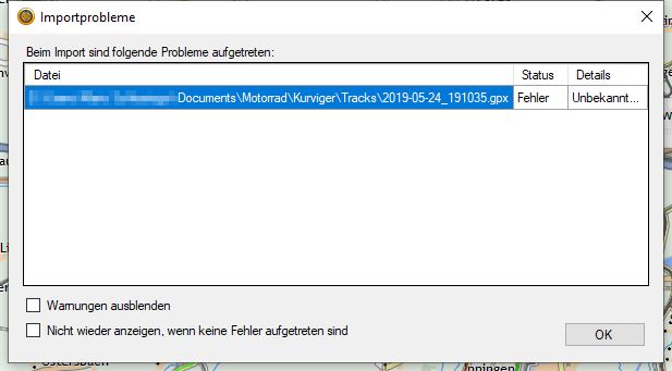
First issue I noticed: after saving my track with all options selected (inluding “GPS accuray” and “Speed”), I wasn’t able to import it into BaseCamp:
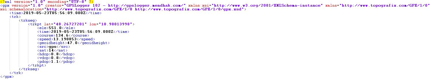
This is how GPSLogger’s GPX files are written (no problems importing into BaseCamp):
This is how Kurviger’s GPX files are written (no import into BaseCamp):
After deleting all the yellow marked sections (speed info) I was able to import it into BaseCamp.
Maybe the reason is a difference between GPX 1.0 and GPX 1.1?
Apart from that the track seems pretty good using the default options in the GPS logging settings. For a distance of aprox. 68km the track consisted of aprox. 700 trackpoints. Accuracy was pretty good (apart from a short “breakout” because of regaining GPS signal after leaving a tunnel).
Maybe you’re right ![]() .
.
Sorry, but I don’t understand what you mean with this behaviour.
Are there any limitations concerning the length of a DB stored track? For example if I forget to save or clear the current track for a couple of tours or days/weeks?
@SchlesiM thanks for the feedback!
That’s right, the old GPX 1.0 had the speed tag, but the current GPX 1.1 allows it as extension.
I could add an option in save dialog to select GPX 1.0 or 1.1 implementation.
While navigation is active, can scroll the map with gestures, but after a while the map auto centers again on user location and navigation continues.
Track data occupy little space, so there is no actual concern.
If it’s not too difficult to do that would be an improvement because tracks would be more flexible to use on other / older applications. And I think there’re still a lot of Basecamp users out there, even after Garmin seems to have decided not to continue it’s development any longer.
Ah, got your point now. Yes, this sounds like a reasonable compromise. Better than just do nothing after selecting a bookmark/waypoint (some users may be confused if they’re not aware of being in “follow position” mode at the moment).
Sounds great. Very helpful for poeple who want to track a longer journey which takes more than one day and is based on several routes. Therefore your tracking solution is in fact more useful than those integrated in most competitor’s apps (or navigation devices)! ![]()
Wow, great new features. Unfortunately cannot test, since this is my trial weekend on a trial bike, but I see the functions are already well used. ![]()
Thank you very much!
Note: that’s how it worked always, so the actual behavior has not changed since then.
Nevertheless we can always improve the user experience. ![]()
TOP Erweiterung.
Hab ich jetzt auch getestet. Funktioniert Bestens!
Besonders gut finde ich, dass der Track Online mit gezeichnet wird.
Bei Halts abseits der Route kann man auf einen Blick erkennen in welcher Richtung es weiter geht. Super ![]() Vorher musste man schon mal Scrollen um die nächste Wegpunktnummer zu finden.
Vorher musste man schon mal Scrollen um die nächste Wegpunktnummer zu finden.