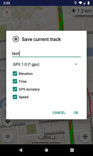
Next version will offer option for GPX version when save track:
TOP Erweiterung.
Hab ich jetzt auch getestet. Funktioniert Bestens!
Besonders gut finde ich, dass der Track Online mit gezeichnet wird.
Bei Halts abseits der Route kann man auf einen Blick erkennen in welcher Richtung es weiter geht. Super ![]() Vorher musste man schon mal Scrollen um die nächste Wegpunktnummer zu finden.
Vorher musste man schon mal Scrollen um die nächste Wegpunktnummer zu finden.
Is it necessary to be online to track the route, or does it work without using Traffic of the mobile?
Best regards juschka
Works offline as far as I can tell
GPS logging can be used totally offline, as all it needs is GPS sensor which works offline.
I’ve tested it yesterday but I still don’t understand the fuction.
After tracking I’ ve stored the file with a new name. Then I’ m able to import this new file to drive it a second time. That’ s the idea, correct?
But where or how can I see the additional information about the velocity I’ve stored before?
And additionally why has this GPS-track to be stored as .gpx and the kurviger-file is not possible?
Thanks in advance
BR juschka
The idea is to offer the GPS logging feature inside the app to everyone needs it for whatever reason, instead of using external trackers. There is not one kind of use, everyone can use it according to any specific requirements.
GPX format is different than Kurviger format. As explained before, GPX stores just coordinates with possible extra data (e.g. elevation), while Kurviger stores complete routes with turn instructions for navigation. Not really directly related.
Can read more also in GPS logging documentation.
The idea of the feature is to keep track of your rides. You could use the file to ride the route again. You could use the file to write a motorcycle diary, share it with your friends or open it with any GPX compatible viewer and pretty much do anything with it. If you are not interested in all these options, you probably don’t need the tracking feature ![]() .
.
Kurviger 1.9.1 was released with several improvements:
- GPS logging: GPX version option (Pro)
When save current track, can select now the GPX version (1.0 or 1.1).
- Routing: actions in waypoints list
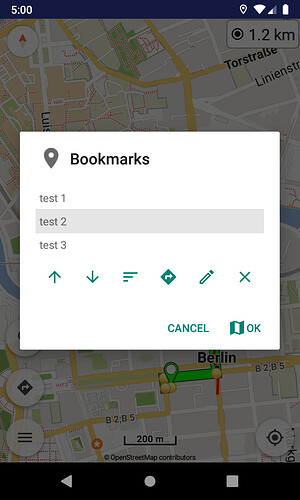
- Bookmarks: actions in bookmarks list
Routing and bookmark lists have a new toolbar button for the selected item. Show it on map and simultaneously open its actions menu.
Thanks for your explanations - but I’ve to add a question. If storing a tracked file in *gpx …was it planned that a lot of waypoints are created?
The topic is, that I’ve seen that the stored gpx-route has a waypoint at each crossing…therefore for few km it could be that a lot of waypoints are created. On the other hand you’ve recommended not to exceed more than about 20-50 waypoints for a route of about 250-300km to handle the file working in the app.
If I’ll would store a tracked route we will create a lot of more waypoints - perhaps hundreds…was this the plan? Will this create performance problems?
Thanks in advance
juschka
That’s the difference between a route and a track.
A route is a calculated way between a few waypoints and the calculation can be done with different profiles / preferences (e.g. “curvy” or “fast”). A route defines how the course should look like. The more waypoints it has the more precisely this course is predefined. So it’s for navigation instruction purposes.
A track is an exact course and is intentionally built by many trackpoints to prevent any variation. It’s somehow comparable with a breadcrump trail. A track is a method to store a course which has been driven (or walked). So it’s more for documentation purposes.
Here you can find some more explanations (sorry, only in German).
Thanks, but that’s clear for me.
The question was: why is the tracked route/track stored in a gpx-file with a lot of waypoints (for sure this mus be, because it’s a gpx-file) - when on the other hand the programming experts of Kurviger explain, that we shouldn’t create routes/tracks with more than 20-25 waypoints to make the file easier to run.
It’s only this contrdiction of explanation while creating routes and storing tracked files, that’s all ![]()
I was wondering if I would get problems if I would reimport a tracked long day-tour with these large amount of waypoints…
Best regards
juschka
GPX waypoints / routes are not the same like tracks (see linked documentation).
“Conceptually, tracks are a record of where a person has been and routes are suggestions about where they might go in the future. For example, each point in a track may have a timestamp (because someone recorded where and when they were there), but the points in a route are unlikely to have timestamps (other than estimated trip duration) because route is a suggestion which might never have been traveled.”
You can choose to reduce the number of waypoints when importing the route. You could set it to 10-20 and add a waypoint manually if it deviates from the track. That should be easy to spot by comparing both on the map.
But first you need an exact recording of the track. This is only possible by storing your position regularly => lot’s of coordinates.
Ok, we’ll try…on sunday 380km, 7h ![]()
BR juschka
Kurviger 1.9.2 is on Google Play:
- Map: option to change the location service (Android, Google)
Can select the location service in map settings, between Google optimized or Android native (default). Should be useful on some devices, if Google doesn’t work perfectly.
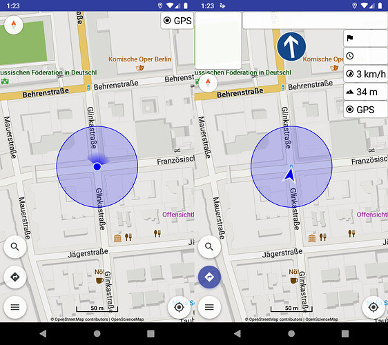
- Map: option to show location accuracy
Location accuracy is now available in map options for those wanting to see GPS precision circle in real time.


