Hallo,
und wieder ein Stück näher an die eierlegende Wollmilchsau
zwecks der Namen von Wegpunkten: Ist es vielleicht möglich die Straßennamenanzeige für die Wegpunkte zu nutzen? Auch als Lauftext und abhängig von der Entfernung?
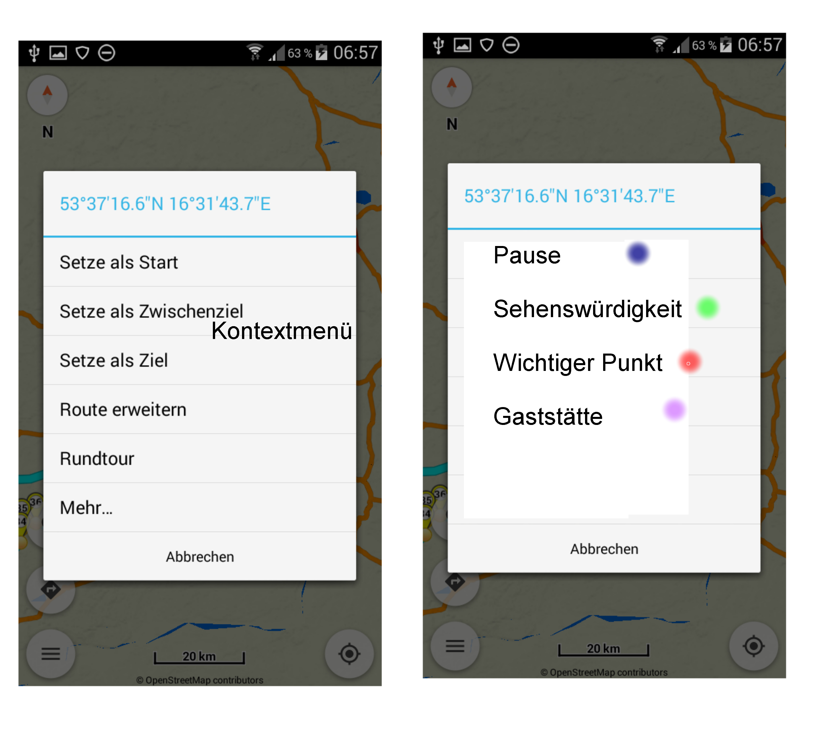
Wie @SchlesiM schon geschrieben hat, finde ich den Wegpunkten bestimmte Farben zuzuordnen sehr hilfreich. So kann ich jeder Wegpunktbedeutung eine Farbe zuordnen. Wichtig wäre es aber, dass ich den Punkten in den Einstellungen eine Farbe gebe, und diese dann bei der Streckenplanung über das Kontextmenü nur noch zuordnen muss.
Endlich habt ihr es geschafft, wunderbar!
Es wäre schön, wenn die Browser-app kompatibel wäre, und wenn die Wegepunkt-Namen der mit Android erstellte Route auch in der web-app zu sehen wären.
Ansonsten sind die guten Ideen schon oben beschrieben worden, ich schließe mich ihnen an, und ich freue mich schon auf die Wegepunkte-typen!
You finally did it, wonderful!
It would be nice if the browser app would be compatible and if the waypoint names of the route created with Android could be seen in the web app.
Otherwise, the good ideas have already been described above, I’m joining them and I’m looking forward to the waypoint types!
Ohne die Ideen schlecht reden zu wohlen, Lauftexte und bunte Farben? Ist mir ehrlich gesagt etwas zu viel des Guten. Eigentlich ist doch das Ziel schöne Strecken zu finden/fahren, ob mit Motorrad oder Cabrio. Wie aber soll man sich “konzentrieren” wenn es “flimmert” und “blinkt” wie ein Spielautomat. Meine Bitte von daher, übertreibt es nicht oder macht entsprechende Funktionen abschaltbar.
Without the ideas bad talk to wohlen, running texts and bright colors? To be honest, it’s a little too much of a good thing for me. Actually, the goal is to find/ride beautiful routes, whether by motorcycle or convertible. But how can you “concentrate” when it “flickers” and “flashes” like a slot machine. My request from there, do not exaggerate it or turn off the corresponding functions.
Indeed like @SchlesiM nicely explained above, when waypoint types are introduced,
many workflows will be simplified, so we can review them after that feature is finished.
zu devemux86
wenn meine Übersetzung stimmt, dann ja, wie @SchlesiM oben schon geschrieben. Nur mal eine Beispiel.
zu luckytown:
Die Straßennamenanzeige wird von mir nur sehr selten genutzt. Wenn ich darüber die Informationen über den nächsten speziellen Wegpunkt erhalte (Beispiel 2 km zuvor) könnte ich damit gut leben. Die Farbgebung hätte für mich den Vorteil, dass ich bei einer Routenänderung (während der Tour) schnell erkenne welche Wegpunkte ich auslassen könnte. Ein weiteres Beispiel: Ich plane eine Route für eine Gruppe. Da könnte ich meinen Routenvorschlag besser organisieren, ohne danach einen Routentext zu verfassen (Wegpunkt 7 Pause, Wegpunkt 13 Burgbesichtigung …)
Und wer es nicht haben möchte, kann es dann einfach in den Einstellungen abschalten.
To find beautiful routes you don’t need a navigation systems (instead you just use your own “nose”). But if you want do follow a previously planned route such features are very useful. Escpecially if you ride in a group and have a certain “program” for the tour (including stopovers, vista points, food&drink halts etc.).
Doesn’t mean you have to use those features after all.
Yes, I’d also prefer if those infos won’t flicker and flash. Just clear and simple display in the navigation panels like all other data.
Yes, Kurviger’s server and website should definitely also support waypoint names to make consistent and complete. Escpecially because route plannig is most likely done on PC / from the website that in the Kurviger app (there routes will mostly only be modified while being on tour and after facing situations you have to react to).
Hallo
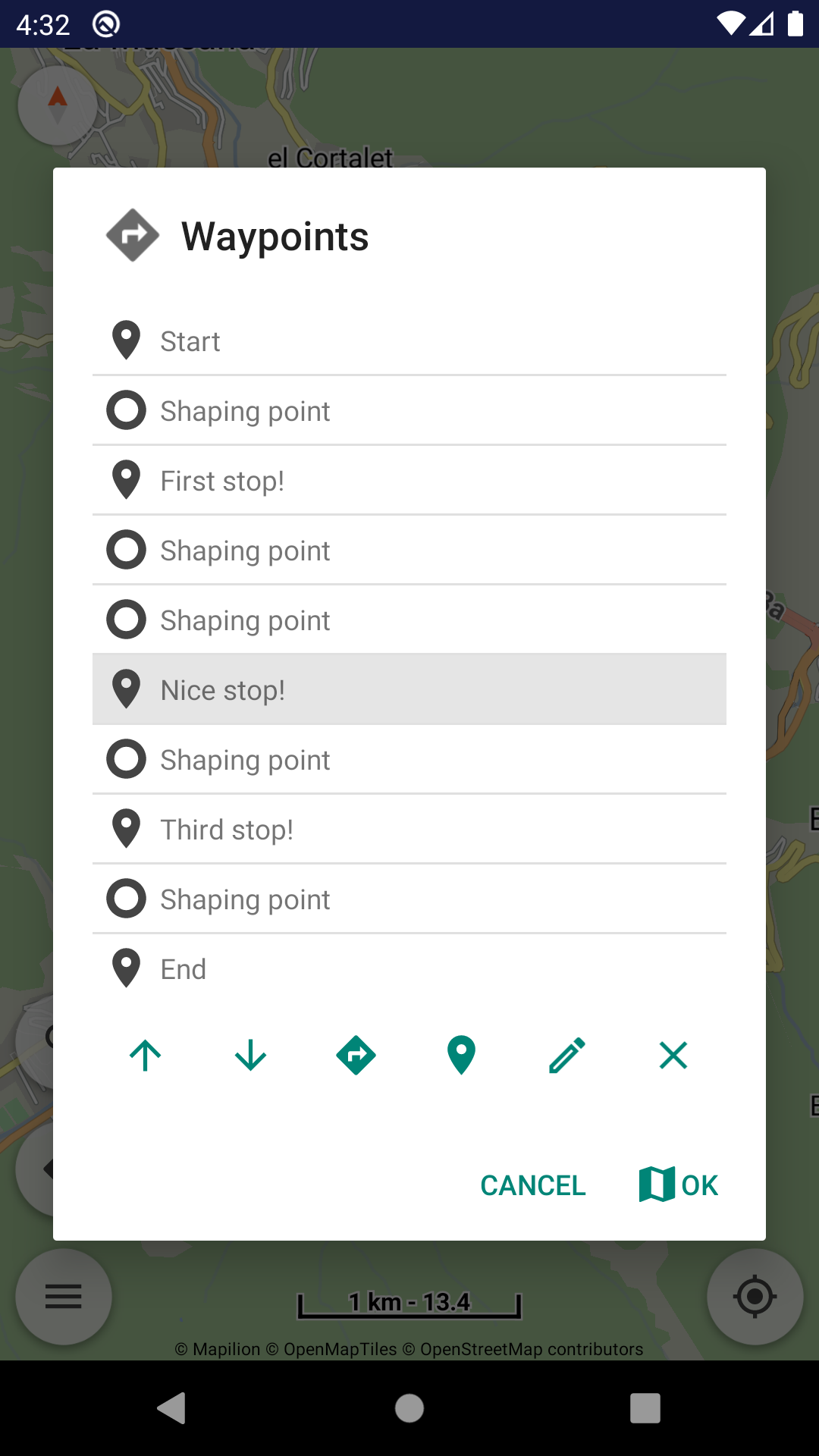
Ich habe in der App bei einer Kurviger tour den Wegpunkt 2 gehalten und bearbeite
umbenannt in Tanken.Speichern und nochmal neu geladen.In der Simulation geht am Wegpunkt 2 nicht die Blase auf.Erst wenn ich drauftippe.Das ist blöd,oder bin ich es?Version 1.13.1
Gruss Rolf
Navigation panels inform and voice guidance speaks when reach waypoints.
And all these will be better tuned when waypoint types arrive in next version.