the problem with the ferry I have since last year… acc to my knowledge the ferry was working these year. For me the actual situation is okay if its blocked in kurviger, than i have to investigate what is on these point and than I would decide move forward or use another routing. So if I could go on the waypoint 7 and tell him please make a direct line from point 6, that would help on my planning.
Here is for example in Mydrive. When I start the tour today, then I also get a blocking information and a detour is calculated
But when I say the tour starts next year in June, then the route gets calculated as if the blocking would not exist
I still get the information that the reason of the blocking is a landslide

But I get the route calculated as I want
This start date for route calculation is in principle like an option “ignore blockings” or something like this.
Hast Du dir den Link angeschaut http://skyeferry.co.uk/? Auf der Homepage ist Twitter eingebunden, am Jun 29, 2020 wurde geschrieben das die Fähre dieses Jahr geschlossen ist. Im Mai und Juni wird um Spenden für den Erhalt der Fähre gebeten. Ich werde die Daten der Fähre bei OSM eintragen, aber ob Sie noch tatsächlich fährt, kann ich nicht garantieren 
Have you looked at the link http://skyeferry.co.uk/? Twitter is included on the homepage, on Jun 29, 2020 it was written that the ferry is closed this year. In May and June donations are requested for the maintenance of the ferry. I will enter the data of the ferry into OSM, but I cannot guarantee that it will still run.
Gern, je aktueller die Karten sind, umso besser.
Es geht mir jedoch nicht um die Fähre oder eine andere konkrete Sperrung. Ich hätte gern bei angeschalter Option “Sperrungen ignornieren” die Route von Kurviger berechnet, die ich in einem halben Jahr fahren möchte und zwar ohne Zwangsumleitungen.
Wenn ich dann in einem halben Jahr die Tour fahre und nochmal drauf schaue, dann ist es schön, wenn Kurviger die eventuell problematischen Abschnitte farblich hervorhebt, damit ich mir diese genauer anschauen kann. Wenn ich dann einen Umweg berechnet haben möchte, dann schalte ich die Option “Sperrungen ignorieren” aus.
However, I am not interested in the ferry or any other concrete blockage. With an active new option “ignore blockage” I would like to have calculated the route by Kurviger, which I want to drive in half a year, without forced detours.
When I drive the tour in half a year and look at it again, then it is nice if Kurviger highlights the possibly problematic sections in a different color so that I can take a closer look at them. If I want to have a detour calculated then, I switch off the option “Ignore closures”.
Im Moment muss ich deswegen Tools benutzen, die das genau so können. Ich würde aber gern ausschließlich Kurviger für vorausschauende Routenplanung verwenden.
So at the moment I have to use tools that can do this. But I would like to use only Kurviger for advanced route planning.
I don’t think this should be offered as an option.
What could be done, is to instead of blocking roads with undefined access, that are likely accessible or only temporarily inaccessible. This requires that the roads are tagged accordingly. We should not allow access to roads that are tagged with access=no or access=private or anything along these lines.
The problem with actual date parsing is that in many cases the data is not uniform enough to provide proper parsing for most cases.
Indeed a date solution is not the best with the possible OSM custom dates and parsing problems.
An on / off switch - like current avoid options - is a much more preferable and convenient solution.
1 Like
Can you generate multiple route (segments) in .kurviger format but still “hook” them together and transport in just one SINGLE file?
Thus still quite a complete routing, but anyway in parts, with pieces of “emptiness” in between, problem on the spot to be solved for and by the more “adventurous” user.
See the example above with both gpx track segments in which the visual piece of “that ferry traject” is simply missing.
Therefore also users should notice important information included in the poi waypoint, ignoring sure could mean a return.
See my answer above:
1 Like
Eine Straße wo gesperrt ist möchte ich fahren.
Kann man die Sperre umgehen.
Eine Straße wo gesperrt ist möchte ich fahren.
Kann man die Sperre umgehen.
Your question(s) belong to the routing category and moved in the relevant topic.
See the above discussion where such an option was suggested for the routing.
Only then the clients (app + website) can use it.
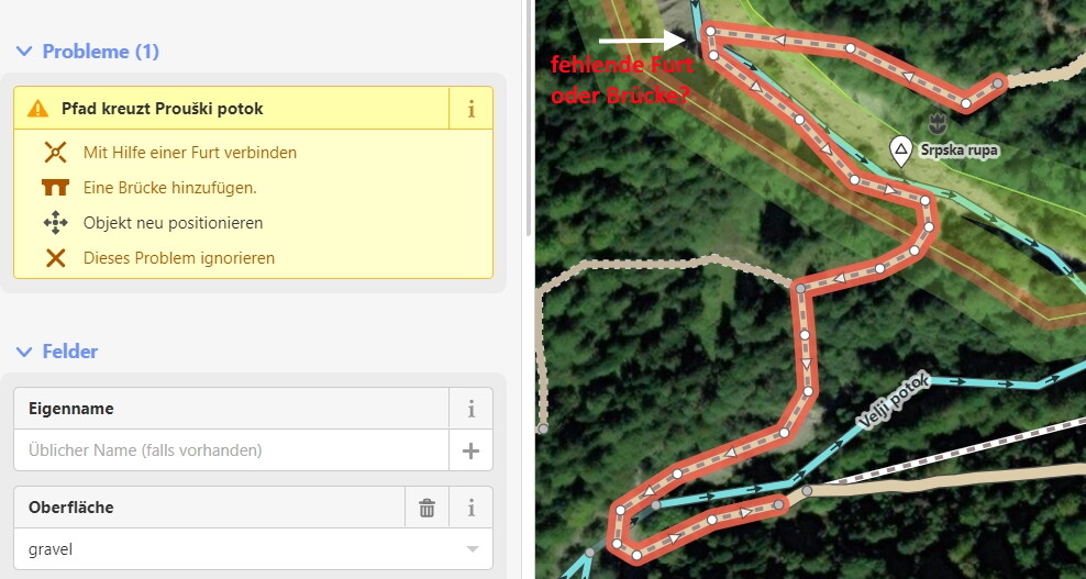
Ein Teilstück Way: 369979701 | OpenStreetMap ist mit |highway|path|
| — | — |
|surface|gravel| getaggt. https://kurv.gr/QZpFF
So bekomme ich es auch hin,  war aber nicht meine Frage.
Hast Du gelesen was die entsprechenden Daten bedeuten? highway=path ist ein allgemeiner Weg für den nicht motorisierten Verkehr (Mehrzwecknutzung oder nicht näher spezifizierte Nutzung).
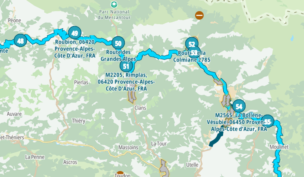
Nachdem die überflüssigen Punkte 18 bis 23 gelöscht und (17) und der neue (18) an die jeweiligen Enden der fahrbaren Strecke gesetzt wurden ergibt sich Kurviger
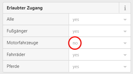
Im OSM ist der verbindende Pfad nicht für Motorfahrzeuge zugelassen, außerdem gibt es den Hinweis auf eine fehlende Furt/Brücke:
Jetzt stellt sich die Frage: Es einfach riskieren, dass man über den Bach kommt?
Ja würde gerne in meiner Tour von WP 17 nach WP 24 fahren, kann und wird auch befahren, leider kann man das in Kurviger nicht.
Wenn man von 17 nach 24 fahren könnte braucht man 18 bis 23 nicht löschen.
Langsam verzweifle ich… Wenn die Daten stimmen dann darf man da nicht langfahren mit Motor-Fahrzeugen… Wie kann man nur so ignorant und uneinsichtig sein?
1 Like
Hallo luckytown, bitte nicht verzweifeln. Das wäre ein Verlust fürs Forum!
Leider gibt es Leute, denen es völlig wurst ist, ob etwas erlaubt ist oder nicht! Dann aber noch rumjammern.