Automations usually need simple options. Like select to record track during navigation, with pause / resume, etc.
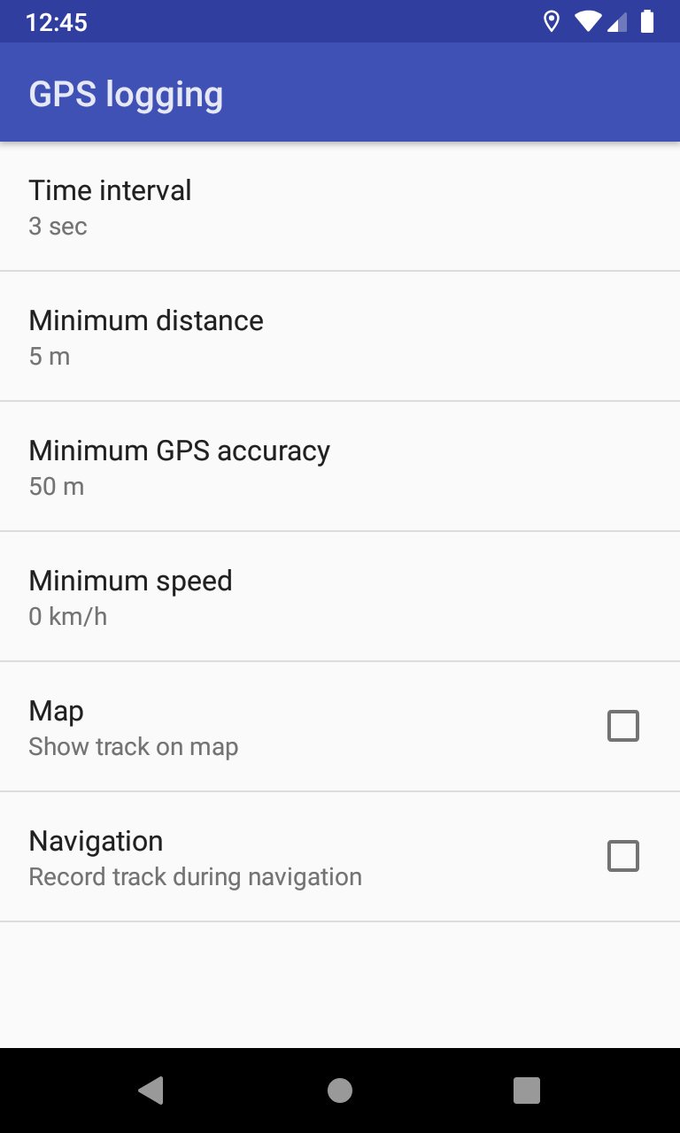
A proposed configuration for the GPS logging inside Kurviger, with each option being adjustable and having sane defaults, could be:
Automations usually need simple options. Like select to record track during navigation, with pause / resume, etc.
A proposed configuration for the GPS logging inside Kurviger, with each option being adjustable and having sane defaults, could be:
I absolutely agree with that. As simple as possible and without the need to start tracking manually.
Looks very promising! ![]()
I’m only missing an option how (and where) to automatically save track logs (e.g. once per day into Kurvigers standard export folder).
App can always know last logged track (like routing), until explicitly save it and prepare a new logging.
Do you find that workflow useful?
Also what about the various options limits / defaults?
Great. That is better than “one file per day”
What does Maximum accuracy mean?
More technical and refers to GPS accuracy, that usually the recorded locations have.
So can select how to filter the locations and keep only the ones with good accuracy.
And the speed is more a low-pass filter, if want to keep locations with movement, though distance filter can help here too.
Just to be sure: does that mean, that the app would always store the last track and overwrite / “forget” it, if I leave the app and restart it later (maybe at the same day)? This could lead to data loss if you forget to explicitely save between two stops or if your tour lasts over more than one day and has different routes.
It’s always painful to lose your tracks, only because you forgot to export/save them (which could happen quite easily, because you often have a lot of “other things” in mind while being on tour).
So I would really prefer an opposite (maybe optional) mechanism which automatically stores all my tracks until I delete them, instead of one which only stores a track if I save it.
For comparison I just checked a few of the tracks in my library.
My Garmin (Zumo 220) tracks have a trackpoint every 1-15 secconds with a distance of 0-450m between them (in fact I don’t quite understand their tracking algorithms). A tour with a length of 250km would lead to a track which has about 4000 trackpoints.
My GPS Logger tracks have a trackpoint every 11 seconds (sometimes, but seldom up to 20), with a distance of 70-450m between them. A tour of about 250km length has somewhat about 1200 trackpoints. By the way: my GPS Logger ist set to a minimum accuracy of 40m.
My GPS Logger tracks therefore have significantly less trackpoints, but this really seems to be enough for archiving and documenting droven tours.
So I think your default options are suitable. Maybe the time interval could be longer (e.g. 10 seconds) without loosing track quality but having smaller log files.
How current routing mechanism works? The app knows always the last calculated route, which is not lost when app exits / restarts. Unless user decides explicitly to export it, clear routing or calculate a new route.
A similar mechanism is proposed for GPS logging too, just replace “route” with “track”. When exit the app and there is a logged track, it’s not lost but will be available at app restart. And user decides if want to save it, clear logging or record a new track.
That’s a good point. ![]()
Sounds like there’s no risk to clear a track by mistake, right? That’s good.
Nevertheless there could be an option to always automatically save the last track (somehow like an “auto-yes” for the question to save the last track when restarting the app). This way it would up to the user to clear unneeded track files later, but you can be sure to have all the track history saved under all circumstances.
My understanding is, that the app will always append new trackpoints to an “internal” track-storage.
The user can then export/save it to a file, or clear the internal track-storage.
No data will be lost, unless the user says “delete”.
If you forget to save your track, you may have more than one day of track logs stored in one file.
Manfred
Really? I understood devmux86 in another way:
Sounds like you can only save/delete or create a new track. No option to continue the existing track. I may be wrong, of course, but this is like I’d interprete it.
Will be able to also continue the existing track. ![]()
GPS logging is certainly not finalized! Being important for most of you, we preferred to start early the discussion - while I still work on that - so we can optimize it better together.
Typical motorcycle speed is 3m/s to 30m/s. (~ 10km/h - 100km/h)
So every 3s means 1 trackpoint every 10m - 100m.
Seams reasonable, but even 10s is fine.
To prevent logging multiple points while standing at the same place.
I would increase it to at least 10m
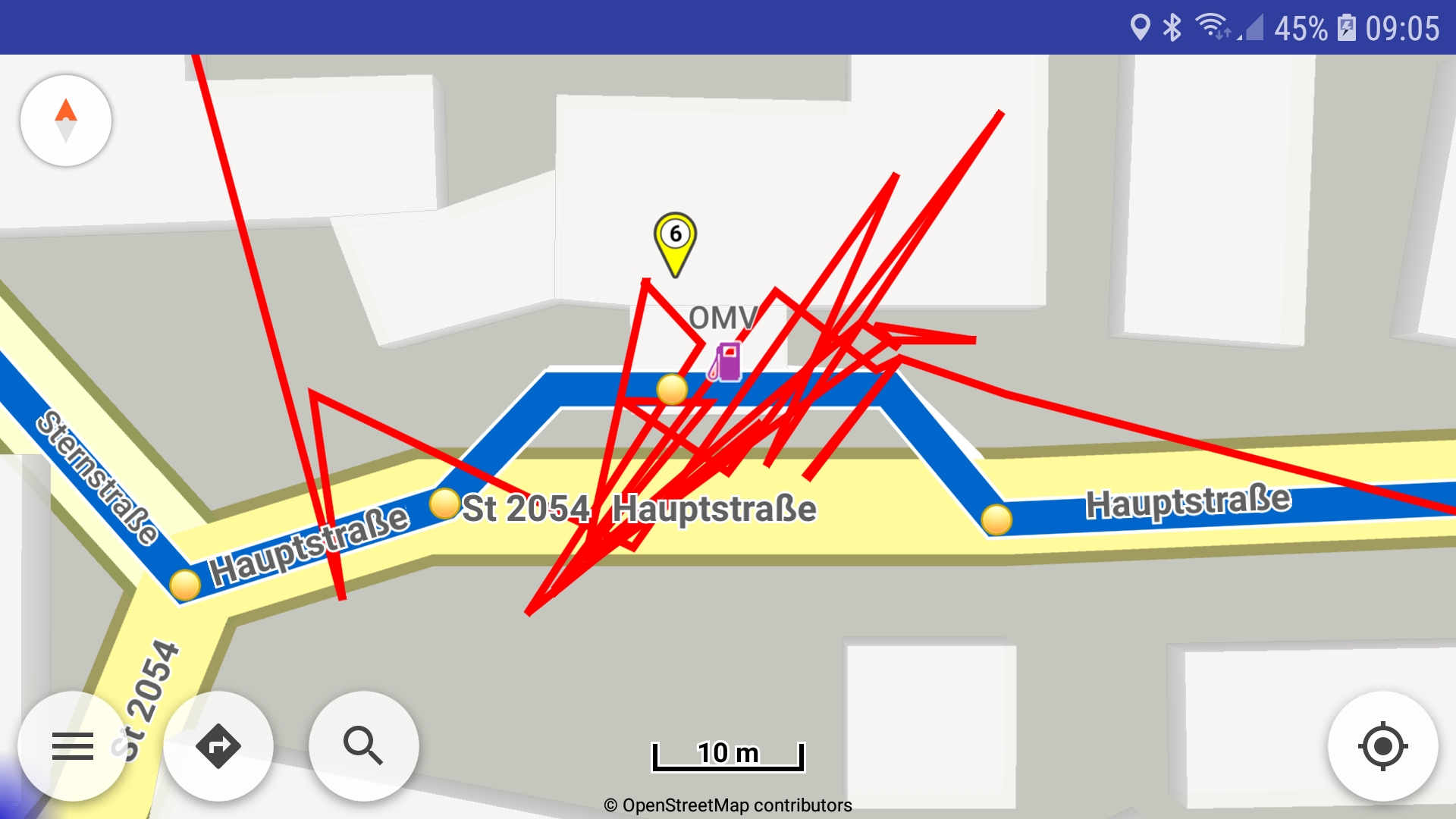
Here is a real world logging of a stop at a gas station.
To prevent logging of obviously incorrect values.
Seams reasonable.
Manfred
GPS logging settings with defaults:
Look perfect. Even with luxury options like color and track width! ![]()
I’m really looking forward to this future version.
I tried the recording feature today and one question remains: Where is the GPX file that contains the recorded track? There is no option in the settings to set the file directory/name and I looked in Phone/Android/data/gr.talent.kurviger.pro/files but there is nothing added.
Nevermind, I just found it out: After stopping the recording, you must tap the recording icon again, then you can save the recording.
Richtig, Sie müssen den Track manuell speichern.
Bei mir ist das “Problem” das ich nicht auf die SD-Card speichern kann, sondern eine Fehlermeldung bekomme.
Auf den internen Speicher dagegen klappt es problemlos.
Right, you have to save the track manually.
My “problem” is that I can’t save the track to the SD card, but get an error message.
On the internal memory however it works without problems.
I describe the GPS logging with more details also here:
(can save current track while recording is active or not)
Can specify the export folder in “Settings | Application | Export folder” for all save / export actions.
Unfortunately Android is more and more restrictive regarding apps to write on SD card.
And from next Android Q there will be more restrictions even in device internal storage.