I’ve seen the blocked road last week also. Please be aware that the complete road is only planned to be closed until end of august - therefore I think it’s not useful to modify in OSM - only if you would to mark it again in unclosed then.
For very short closures it’s not recommended to mark it in OSM.
BR
juschka
1 Like
Hmmm - ich sehe weder eine Änderung an der Germeringer Str. in den letzten Wochen, noch kann ich eine Fehlermeldung finden:
Bist Du sicher, daß Du etwas in OSM geändert/gemeldet hast?
Just a minor correction: short closures should be marked in OSM as well, but with conditional access. Using conditional access rules you can mark a road to be closed for just a few days and it doesn’t interfere with apps / services that don’t support these tags.
I think the ADAC is using road incident data from Here. So this is copyrighted data that we can’t use. I am regularly checking to find closures and add them to OSM - but there are just too many roads and too many constructions sites  - so if you find closure, it would be great to enter it in OSM - if you ware wondering how to do this, I am happy to give you a bit of help?
1 Like
Would be nice if you could explain to me, how to add a closed road to OSM - I’ve made a mistake last time and my changes weren’t published.
Maybe a How To would be interesting for more people.
EDIT:
I think something like this would be right
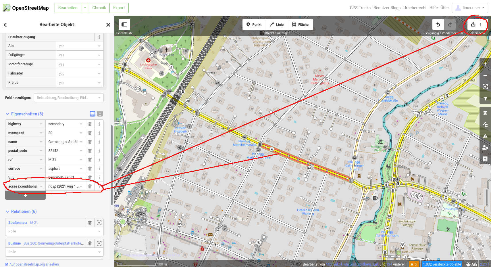
“access:conditional = no @ (2021 Aug 16- 2021 Sep 03)”
1 Like
This looks absolutely correct.
You would then need to add this information to OpenStreetMap, the easiest option would be to use the iD editor. Here is a video tutorial: https://www.youtube.com/watch?v=5q7ypL0Osqc&ab_channel=RyndoLabs
You would then need to go to the road on the map, click edit and click on the road, then add the tag.
Does this work?
Thanks for the video. The Tag is added.
Unfortunately OSM still routes me over this road.
Couldn’t we get a feature for Kurviger (if it is possible) to report such blocked roads from the Kurviger Website and the app.
The update for the Kurviger routing server takes about 2 days.
I am not sure how often the routing data for the different routing services at OSM is updated, but it’s probably daily or weekly.
Reporting could be possible, but then someone still needs to enter the data correctly to OSM - so I am not sure if there is a lot of added benefit.
A simple reporting feature is available on OSM as well: Notes - OpenStreetMap Wiki - so it probably makes more sense to use that reporting feature  .
.
I can’t, too!
I set up a small overpass turbo search:
It seems that no ways with name=“Germeringer Straße” have been modified after February 2021 (if you change the timestamp to former time, e.g. January, you get some hits - if you change it to 1990 you get the whole street)
My fault, I’ve added the Tag “temporary access:conditional = no @ (2021 Aug 16- 2021 Sep 03)” which was denied because it’s only “access:conditional = no @ (2021 Aug 16- 2021 Sep 03)” .
I’ve added it again and waiting for approval.
1 Like
You usually don’t need to wait for approval, I think this is only an option that you select optionally.
I really don’t know whats the problem.
When I go in the “edit mode” and select the road, I can see the Tag that I’ve added. But when I start calculating a route from Point A to Point B it still says that I should drive on the closed road.
I’m near to giving up.
You need to upload your changes to OSM
I’ve done exactly the steps in your screenshots.
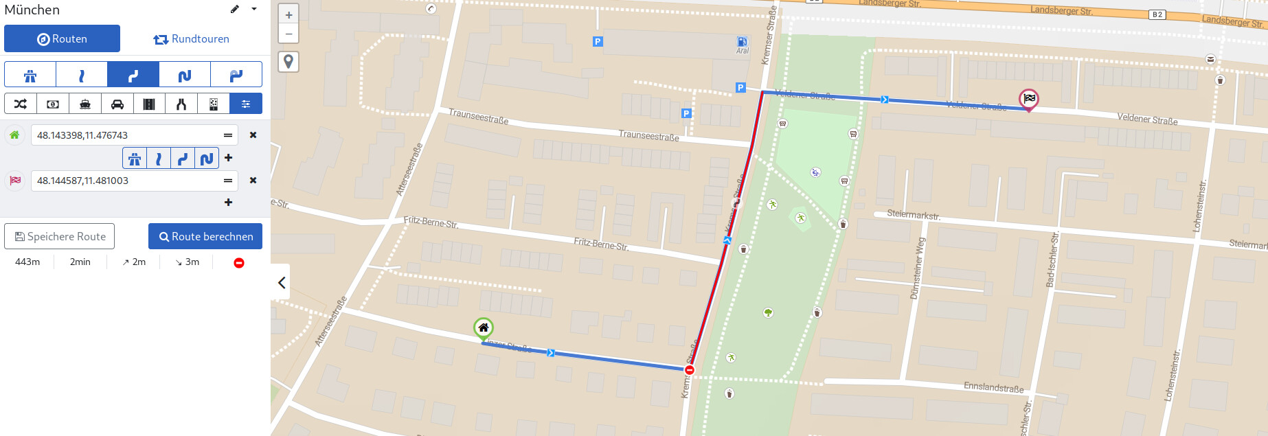
I’ve noticed that the blocked road will be avoided if I select Graphhopper in the drop down menu (See screenshot).
But if I’m selecting OSRM - it’s still navigating over the closed road.
Edit:
Someone in the OSM [Forum] (Marked route as closed, but's still available - OSM Help) told me that OSRM does not support the “access:conditional”, Graphhopper does - so is there a possibility to change from OSRM to Graphhopper in the Kurviger app?
Kurviger does not use either. We run our own servers and infrastructure which uses a modified version of GraphHopper. As Kurviger tourer you should be able to see the closed roads on the website and could change your routing manually.
1 Like
Huge thanks to @boldtrn , as you can see in my screenshot - I’ll see the blocked road when using the Kurviger tourer. So in the future I just have to add new blocked roads to OSM.
But wouldn’t it make much more sense, to avoid such a road by default? Is there any chance to get a “avoid potentially blocked roads” button ?
We had a discussion about this some time ago: Website: Conditional restrictions
I am always open to discussing this again, I am not sure if it makes sense though, because many blocked roads are based on weekdays, seasons (like winter) etc. and might not match your current situation - whereas for closed roads like a construction site this might make sense, but we don’t have any option to distinguish them right now.
In my eyes it would always make sense to avoid a closed road (weekends, seasons, etc. are also a time restrictions)
Seeing those closed roads is a success for myself, but is this feature available for the android app too? Haven’t found it yet.
We will think if this is possible or useful on mobile limited screens.
3 Likes