Opening an old .kurviger file in the app and exporting it as GPX (online) afterwards might lead to route deviations between .kurviger file and exported GPX.
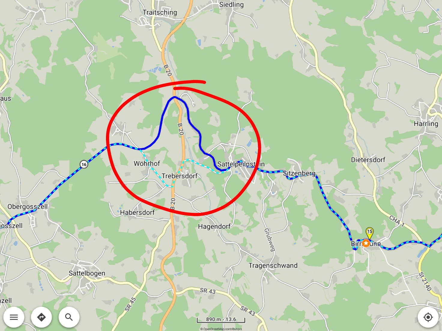
and importing that GPX afterwards as overlay (track) you can see a deviation between waypoint 15+16 (blue: route of .kurviger file, cyan dashed: Overlay track of GPX):
I understand that such deviations can not be avoided, probably because the app transfers only the waypoints to the server during request, so the server has to do a new routing - and if OSM data or algorithm has changed in between this can lead to a different route.
But perhaps the app can check the track returned by server for deviation from track in .kurviger file and give a hint, if the returned track does not match the one in .kurviger file.
(Of course the deviation in this example is small, ~2km, but there were other cases where the GPX route had significant changes).
I am wondering: As the app does not send the whole track to server (that would not be useful, of course) only the app could compare track of .kurviger file with GPX track - so I have chosen the “App” category.
My 1st idea was "3rd party integration ", but this effect occurs only in the app: As far as I understand the website does a new routing when opening an .kurviger file, so both routes (the shown route and the GPX route) are identical.
Hmm - I wanted to ride the route using my Garmin for navigation - unfortunately Garmin did not yet implement an import function for .kurviger files yet
When importing a .kurviger file in website and app sometimes the routes are different in website and app. The reason is the behaviour of website and app:
website: The route is calculated due to data in the *.kurviger file. Showed information of the route (route in map view, instructions, …) is taken from the calculation.
Advantage: Changes in map and routing data are considered! When the data are actual you don’t have surprises of e.g. road blocks or similar things.
You can compare the course of the originally route and the calculated route, when you at import select the track as overlay.
Disadvantage: You can’t compare the course of the original route and the calculated route, when you don’t show the track as overlay.
Disadvantage: When exporting the route again with same file name in same folder the original route is lost.
app: No calculation of the route. All showed information of the route (route in map view, instructions, …) is taken direct from the *.kurviger file.
Advantage: Always the information of the original route is available.
Intended for offline use of the app with .kurviger files
To avoid the disadvantages (see below) you can trigger a recalculation (long press on a waypoint, select move, just press ok). When you will see differences between recalculated route and original route then at import you should have selected “Overlay + Routing” and “Original route”.
Disadvantage: Changes in map and routing data are NOT considered. When driving along the route there may be some SURPRISES, e.g. actual road blocks or similar!
So both behaviours have advantages and disadvantages. I don’t really know which behaviour is better. Sometime the one or other behaviour favors more.
EDIT: Due to feedback in this threat some additional info is added above.
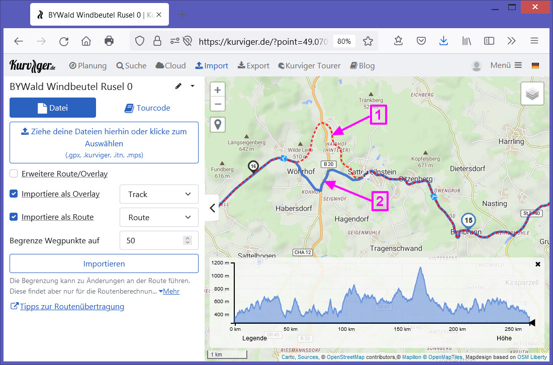
There I’m a little bit confused due to the course marked with 1 and 2.
Why there is a change between track and route in the courses marked with 1 and 2?
What happened there? Which course was the originally route?
EDIT: Due to feedback in this threat some additional info is added:
Now it’s much more clear.
Course 1 (blue: route of .kurviger file in rumbrummer screenshot) is the course of the originally route (calculated about a year ago).
Course 2 (cyan dashed: Overlay track of GPX in rumbrummer screenshot) is the course of the route when (re)calculated now when imported as .kurviger or .gpx file.
Reason of differences between one year old and actual calculation perhaps depending on changed map (routing) data or routing algorithm.
Sorry for no clear definition. In the website the colours and line styles of track and route are not selectable. Therefore I didn’t mention .
In the website screenshot marked with 1 is the track as overlay of the imported .kurviger file and therefore should be the track of the original route, marked with 2 is the recalculated route of the imported .kurviger file.
Course 1 (blue: route of .kurviger file in rumbrummer screenshot) is the course of the originally route (calculated about a year ago).
Course 2 (cyan dashed: Overlay track of GPX in rumbrummer screenshot) is the course of the route when (re)calculated now when imported as .kurviger or .gpx file.
Reason of differences between one year old and actual calculation perhaps depending on changed map (routing) data or routing algorithm.