Hi,
wasn’t sure about writing in English. My experience in other Forums in Germany is that people complain, because they don’t understand. OK, will do!
That’s what I had in mind, too!
Something about the “etc.”
Situation: You drive in Navigation mode on your route and hit a road block. No signs for deviation, the sun is high and hot, on your sunglasses you can hardly see the display, contrast is low, you sweat like a pig under helmet and gloves. Almost impossible to modify the current route w/ new way points under such conditions on the small mobile screen, no mouse pointer, only your thick fingers… Hence you decide to make a U-turn, driving back to the last crossroad, hoping if you turn there at random choice right or left that re-routing will solve your problem. While you are driving back, the mobile keeps annoying you that you are driving in the wrong direction and that you should do another U-turn. In such cases Murphy is always around the corner, and in other Apps I had frequently the case that the re-routing was then driving me down into smaller and smaller streets, loosing completely my orientation and 10 min later the navigation has brought me to a point 500m behind the place where I did the 1st U-turn and where the road is still blocked. Another problem was that the re-routing decided about a new route to the next WP, which bypassed almost the complete original route segment. That’s usually the moment where you start screaming at the device and their developers.
What I am looking for is a 1 touch button in Nav-Mode telling the navigator that the road is blocked for x Km, (where x could be fix like 3 Km at a first implementation). A short term re-routing should then kick in and bring me around this road block back onto my old route x Km later. There must be caviates around this, because on Highways the Navigator should never tell you to make a U-turn, because this would be a security killer for your App.
Rgds
hk
Indeed. @lve0200 you got the point. This is exactly what I wanted to ask for. A de-tour that will help me drive past the road blocks, construction sites etc.pp. Exactly that scenario as you describe happened to me 3 weeks ago
while riding to GAP. Normally one would hit “de-tour” and specify for how much meter/km the de-tour should be calculated. This is for example a nice feature of (recently discontinued) Navigon software.
This, together with the offline route calculation are for me the most important additions to the app as-is now.
Hello, I am new to Kurviger app, and will try to use it on our next trip, about 1600 km at the beginning of June 2019.
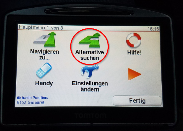
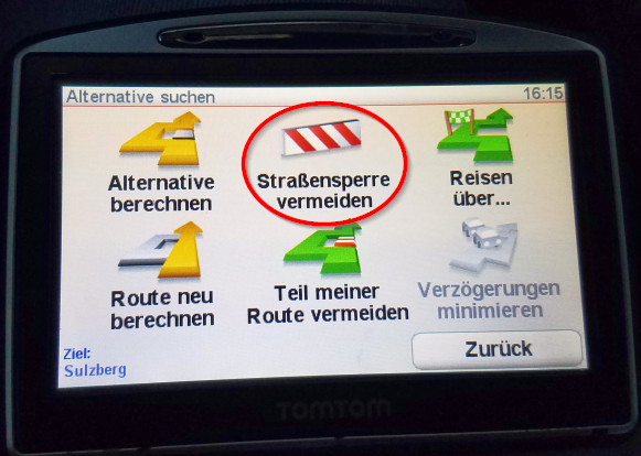
Until now I always did routing on www.kurviger.de and exported the route to my TomTom Go 730 navigation system. The TomTom has the great advantage of the function “Roadblock in 100 m”, so exactly the function mentioned here. I needed this function many times on our last few trips…
Is there a chance that this feature will be available in the next few month? It would really be great!
This feature (and offline routing) would definitely make Kurviger the best navigation app!
There is a chance :), but please note, we don’t provide ETAs for features.
May I ask how you use this feature? Is it mostly for construction sides? Is it something you would do when you parked the bike and took off your gloves?
I actually use the feature on unexpected construction sites while driving. On the last tour we came across several such unexpected roadblocks because of construction sites. Sometimes I pressed the button “Roadblock in 100 m” while driving, as soon as I saw the construction site, without a break, without taking off my gloves.
Thanks for the reply. I am not a Garmin pro but I used one a couple of times. I have never seen this button . Is this only available on some devices or is this feature hidden?
Coming back to this topic I wanted to ask if there is any timeline for this new function?
I had the problem also last week.
The road was blocked (working on the road for more than 3 weeks, but this will not be documented in the OSM maps). After driving away we lost the information where to go, no sign to help to find the correct way …and after a great turn of about 30km we came back exactly at the same point of the blocked road again
How could this be avoided - would the new function help in this case?
Alternatively can disable rerouting and use the new route indicator with direction arrow to help resume the route (its options are in “Settings | Navigation | Route indicator”).
No the arrow don’t helps if the route is going in a really large distance away from the origin way. Think that was also the problem - in 30km around we didn’t realise that we’re coming back on the same exit shortly before the blocking. the arrow helps in case of only one road in parallel or something like this, but outside a city the distances are mostly too far.
Ok, then let’s wait, I hope to get this new function soon.
Ok, then let’s wait, I hope to get this new function soon.
me too!, after waiting since almost 1 year 4it.
I may also add to it, because in villages, you don’t know, if during your search for a deviation, you may enter into a residential area with a maze of 1-ways and no exit.
When thinking a bit more about this feature I was wondering what a good distance to avoid would be.
When you come to a closed road, you usually don’t know how long the closure is (unless you can see the end of the closure).
How do you usually handle this with your current navigation device?
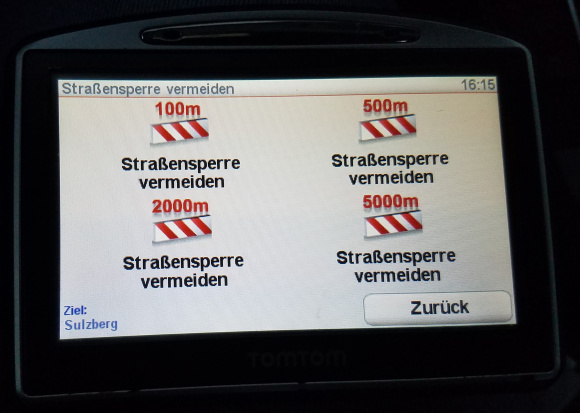
For example above there was a screenshot from a TomTom device offering 100,500,2000,5000m distances. Are these reasonable choices?
Are you for example always go for the same options? How do you choose which option you pick?
The distances in the TomTom screenshots above only describe where the roadblock starts, but not how long it is and where it ends. To my knowledge, there is no way to tell TomTom how long it is.
I always use 100m or 500m, which means that the roadblock starts right in front of me. Of course, it can then happen that you are led to the barrier again, if this is very long …


 . Is this only available on some devices or is this feature hidden?